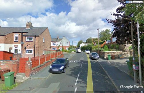
Robin Hood Lane (Helsby)
| Locality | |
|---|---|
| Coordinate | 53.267029, -2.769731 |
| Adm. div. | Cheshire |
| Vicinity | In Helsby |
| Type | Thoroughfare |
| Interest | Robin Hood name |
| Status | Extant |
| First Record | 1861 |
| A.k.a. | Robin Hood lane |
By Henrik Thiil Nielsen, 2017-01-21. Revised by Henrik Thiil Nielsen, 2021-02-13.
'Robin Hood Lane' is the name of what on any sensible view is not one but two or more properly three streets in Helsby. At least one of these streets and their collective name were in existence by 1861.
The longest segment of Robin Hood Lane connects Old Chester Road in the north with Chester Road in the south, looping east en route and turning back to cross itself and continue west to Chester Road where it meets up with Lower Robin Hood Lane. As if this was not peculiar enough, a short cul-de-sac leading north from the eastern loop is also named 'Robin Hood Lane'. On the north-eastern corner of the intersection of Chester Road, Robin Hood Lane and Lower Robin Hood Lane stood until recently the Robin Hood. The two lanes as well as three fields in the immediate vicinity that are also named after the outlaw all owe their names to the pub.
The lane(s) is/are not labelled on any of the O.S. maps listed below (see Maps section), but several other streets in Helsby also lack labels on the maps. "Robin Hood lane" figures already in the 1861 Census.[1]
Gazetteers
- Not included in Dobson, R. B., ed.; Taylor, J., ed. Rymes of Robyn Hood: an Introduction to the English Outlaw (London, 1976), pp. 293-311
- Not included in Dodgson, John McN.; Rumble, Alexander R. The Place-Names of Cheshire, pts. I-V (English Place-Name Society, vols. XLIV-XLVIII, LIV, LXXIV) (Cambridge, 1970-72; [s.l.], 1981; Nottingham, 1997).
MS sources
- 1861 Census, Cheshire, online at the Genealogist, Piece 02599, Image 00188, Item 27.
Maps
- 25" O.S. map Cheshire XXXII.6 (c. 1874; surveyed c. 1872). No copy in NLS
- 25" O.S. map Cheshire XXXII.6 (1898; rev. 1897) (georeferenced)
- 25" O.S. map Cheshire XXXII.6 (1898; rev. 1897)
- 25" O.S. map Cheshire XXXII.6 (1935; rev. 1908)
- 6" O.S. map Cheshire XXXII (1881; surveyed 1873-74)
- 6" O.S. map Cheshire XXXII.NW (1899; rev. 1897) (georeferenced)
- 6" O.S. map Cheshire XXXII.NW (1899; rev. 1897)
- 6" O.S. map Cheshire XXXII.NW (1911; rev. 1908)
- 6" O.S. map Cheshire XXXII.NW (c. 1936; rev. 1908)
- 6" O.S. map Cheshire XXXII.NW (c. 1944; rev. 1938).
Also see
Notes
- ↑ Online at the Genealogist, Piece 02599, Image 00188, Item 27.

