|
|
| (32 intermediate revisions by the same user not shown) |
| Line 1: |
Line 1: |
| __NOTOC__ | | __NOTOC__{{PlaceNamesItemTop|Lat=53.672340|Lon=-1.531894|AdministrativeDivision=Yorkshire|Vicinity=2 km SW of central Wakefield|Type=Thoroughfare|Interest=Miscellaneous|Status=Extant|Demonym=|Riding=West|GreaterLondon=|Year=|Aka=|Century=|Cluster1=Wakefield|Cluster2=|Cluster3=|Image=sherwood grove wakefield gm.jpg|Postcards=|ExtraCat1=Places named after Sherwood Forest|ExtraCat2=|ExtraCat3=|ExtraCat4=|ExtraCat5=|GeopointPrefix=|GeopointSuffix=|StatusSuffix=|DatePrefix=|DateSuffix=}} |
| {{Infobox | | {{#display_map:{{#var:Coords}}~{{#replace:{{PAGENAME}}|'|'}}|width=34%|enablefullscreen=yes}}<div class="pnMapLegend">Sherwood Grove.</div> |
| |header1=Locality
| | [[File:sherwood grove wakefield gm.jpg|thumb|right|500px|Sherwood Grove / Google Earth Street View.]]<div class="no-img"> |
| |label2=Coordinates
| | <p id="byline">By Henrik Thiil Nielsen, 2014-10-19. Revised by {{#realname:{{REVISIONUSER}}}}, {{REVISIONYEAR}}-{{REVISIONMONTH}}-{{REVISIONDAY2}}.</p> |
| |data2=[[Geopoint::53.672340,-1.531894]]
| | Sherwood Grove is encircled by [[Little John Crescent (Wakefield)|Little John Crescent]], to the west, and [[Robin Hood Crescent (Wakefield)|Robin Hood Crescent]] to the right. The three little streets are situated in a residential area c. 2 km SW of central Wakefield.{{PlaceNamesItemAllusionsAndRecords}} |
| |label3=Adm. div.
| | == Gazetteers == |
| |data3=[[pnadmdiv::West Riding of Yorkshire]]
| |
| |label4=Vicinity
| |
| |data4=[[pnvicinity::2 km SW of central Wakefield]]
| |
| |label5=Type
| |
| |data5=[[pntype::Thoroughfare]]
| |
| |label6=Interest
| |
| |data6=[[pninterest::Miscellaneous]]
| |
| |label7=Status
| |
| |data7=[[pnstatus::Extant]]
| |
| |label8=First Record
| |
| |data8=[[pnfirstrecord::]]?
| |
| }} | |
| {{#display_map:53.672340,-1.531894|width=34%}}<div class="pnMapLegend">Approximate location of Sherwood Grove.</div> | |
| [[File:sherwood grove wakefield gm.jpg|thumb|right|500px|Sherwood Grove (photo: Google Earth).]] | |
| <p id="byline">By Henrik Thiil Nielsen, 2014-10-19. Revised by {{#realname:{{REVISIONUSER}}}}, {{REVISIONYEAR}}-{{REVISIONMONTH}}-{{REVISIONDAY2}}.</p><div class="no-img"> | |
| Sherwood Grove is encircled by [[Little John Crescent (Wakefield)|Little John Crescent]], to the west, and [[Robin Hood Crescent (Wakefield)|Robin Hood Crescent]] to the right. The three little streets are situated in a residential area c. 2 km SW of central Wakefield.<!--=== Allusions === | |
| {{#ask:[[Category:Allusions (Sherwood Grove in Wakefield)]]|format=embedded|embedformat=h4|columns=1|limit=1000|sort=Utitle}}--> | |
| === Gazetteers ===
| |
| * Not included in {{:Dobson, Richard Barrie 1976a}}, pp. 293-311. | | * Not included in {{:Dobson, Richard Barrie 1976a}}, pp. 293-311. |
| === Also see === | | {{PlaceNamesItemAlsoSee}}<!-- |
| * [[Wakefield place-name cluster]]
| | == Notes ==--> |
| * [[Places named after Sherwood Forest]].
| |
|
| |
|
| | </div> |
|
| |
|
| </div>
| |
| <div id="dplcatlinks" class="subcategory"><div id="dplcatarea">
| |
| {{#ask: [[Category:English place-names]]
| |
| [[Category:Yorkshire place-names]]
| |
| [[Category:West Riding of Yorkshire place-names]][[Utitle::<<{{#replace:{{uc:{{PAGENAME}}}}|'|'}}]]|order=descending|searchlabel=|format=template|introtemplate=BeforeNav|template=Nav|outrotemplate=Previous|link=none|limit=1|sort=Utitle}}[[West Riding of Yorkshire place-names]]{{#ask: [[Category:English place-names]]
| |
| [[Category:Yorkshire place-names]]
| |
| [[Category:West Riding of Yorkshire place-names]][[Utitle::>>{{#replace:{{uc:{{PAGENAME}}}}|'|'}}]]|order=ascending|searchlabel=|format=template|introtemplate=BeforeNav|template=Nav|outrotemplate=Next|link=none|limit=1|sort=Utitle}}
| |
|
| |
|
| <p>{{#ask: [[Category:Yorkshire place-names]][[Utitle::<<{{#replace:{{uc:{{PAGENAME}}}}|'|'}}]]|order=descending|searchlabel=|format=template|introtemplate=BeforeNav|template=Nav|outrotemplate=Previous|link=none|limit=1|sort=Utitle}}[[Yorkshire place-names]]{{#ask: [[Category:Yorkshire place-names]][[Utitle::>>{{#replace:{{uc:{{PAGENAME}}}}|'|'}}]]|order=ascending|searchlabel=|format=template|introtemplate=BeforeNav|template=Nav|outrotemplate=Next|link=none|limit=1|sort=Utitle}}</p>
| |
|
| |
|
| {{#ask: [[Category:English place-names]][[Utitle::<<{{#replace:{{uc:{{PAGENAME}}}}|'|'}}]]|order=descending|searchlabel=|format=template|introtemplate=BeforeNav|template=Nav|outrotemplate=Previous|link=none|limit=1|sort=Utitle}}[[Place-names]]{{#ask: [[Category:English place-names]][[Utitle::>>{{#replace:{{uc:{{PAGENAME}}}}|'|'}}]]|order=ascending|searchlabel=|format=template|introtemplate=BeforeNav|template=Nav|outrotemplate=Next|link=none|limit=1|sort=Utitle}}</div></div> | | {{PlaceNamesItemNavigation}} |
| [[Category:English place-names]]
| |
| [[Category:Yorkshire place-names]]
| |
| [[Category:West Riding of Yorkshire place-names]]
| |
| [[Category:Place-names-topics]]
| |
| [[Category:Wakefield place-name cluster]]
| |
| [[Category:Places named after Sherwood Forest]]
| |
| [[Category:Miscellaneous]]
| |
| {{#set:Utitle={{#replace:{{uc:{{PAGENAME}}}}|'|'}}}}
| |
| {{#set:Pnimage=sherwood grove wakefield gm.jpg}}
| |
| Locality |
|---|
| Coordinate |
53.67234, -1.531894 |
|---|
| Adm. div. |
West Riding of Yorkshire |
|---|
| Vicinity |
2 km SW of central Wakefield |
|---|
| Type |
Thoroughfare |
|---|
| Interest |
Miscellaneous |
|---|
| Status |
Extant |
|---|
| First Record |
|
|---|
Loading map...
{"minzoom":false,"maxzoom":false,"mappingservice":"leaflet","width":"34%","height":"400px","centre":false,"title":"","label":"","icon":"","lines":[],"polygons":[],"circles":[],"rectangles":[],"copycoords":false,"static":false,"zoom":false,"defzoom":9,"layers":["OpenStreetMap","NLS","Stamen.Terrain"],"image layers":[],"overlays":[],"resizable":false,"fullscreen":true,"scrollwheelzoom":true,"cluster":false,"clustermaxzoom":20,"clusterzoomonclick":true,"clustermaxradius":80,"clusterspiderfy":true,"geojson":"","clicktarget":"","imageLayers":[],"locations":[{"text":"\u003Cdiv class=\"mw-parser-output\"\u003E\u003Cp\u003ESherwood Grove (Wakefield)\n\u003C/p\u003E\u003C/div\u003E","title":"Sherwood Grove (Wakefield)\n","link":"","lat":53.67234,"lon":-1.531894,"icon":""}],"imageoverlays":null}
Sherwood Grove.
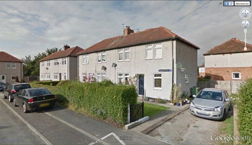
Sherwood Grove / Google Earth Street View.
By Henrik Thiil Nielsen, 2014-10-19. Revised by Henrik Thiil Nielsen, 2021-01-06.
Sherwood Grove is encircled by Little John Crescent, to the west, and Robin Hood Crescent to the right. The three little streets are situated in a residential area c. 2 km SW of central Wakefield.
Gazetteers
Also see

