Robinhood Wood (Tritlington): Difference between revisions
From International Robin Hood Bibliography
mNo edit summary |
m (Text replacement - "* 25" map" to "* 25" O.S. map") |
||
| (One intermediate revision by the same user not shown) | |||
| Line 1: | Line 1: | ||
__NOTOC__{{PlaceNamesItemTop|Lat=55.233763|Lon=-1.664414|AdministrativeDivision=Northumberland|Vicinity=''c.'' 800 m NE of Tritlington|Type=Natural feature|Interest=Robin Hood name|Status=Extant|Demonym=English|Riding=|GreaterLondon=|Year=1866|Aka=|Century=|Cluster1=|Cluster2=|Cluster3=|Image=robinhood-wood-tritlington-google-earth.jpg|Postcards=|ExtraCat1=Places named Robin Hood's Wood|ExtraCat2=Robinhood place-names|ExtraCat3=|ExtraCat4=|ExtraCat5=|ExtraLink1=|ExtraLink2=|ExtraLink3=|ExtraLink4=|ExtraLink5=|ExtraLinkName1=|ExtraLinkName2=|ExtraLinkName3=|ExtraLinkName4=|ExtraLinkName5=|GeopointPrefix=|GeopointSuffix=|StatusSuffix=?|DatePrefix=|DateSuffix=}} | __NOTOC__{{PlaceNamesItemTop|Lat=55.233763|Lon=-1.664414|AdministrativeDivision=Northumberland|Vicinity=''c.'' 800 m NE of Tritlington|Type=Natural feature|Interest=Robin Hood name|Status=Extant|Demonym=English|Riding=|GreaterLondon=|Year=1866|Aka=|Century=|Cluster1=|Cluster2=|Cluster3=|Image=robinhood-wood-tritlington-google-earth.jpg|Postcards=|ExtraCat1=Places named Robin Hood's Wood|ExtraCat2=Robinhood place-names|ExtraCat3=|ExtraCat4=|ExtraCat5=|ExtraLink1=|ExtraLink2=|ExtraLink3=|ExtraLink4=|ExtraLink5=|ExtraLinkName1=|ExtraLinkName2=|ExtraLinkName3=|ExtraLinkName4=|ExtraLinkName5=|GeopointPrefix=|GeopointSuffix=|StatusSuffix=?|DatePrefix=|DateSuffix=}} | ||
{{#display_map:{{#var:Coords}}~{{#replace:{{PAGENAME}}|'|'}}|width=34%|fullscreen=yes}}<div class="pnMapLegend">Robinhood Wood, Tritlington</div> | {{#display_map:{{#var:Coords}}~{{#replace:{{PAGENAME}}|'|'}}|width=34%|fullscreen=yes}}<div class="pnMapLegend">Robinhood Wood, Tritlington</div> | ||
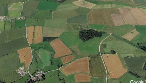
[[File:{{#var:Image}}|thumb|right|500px|Robinhood Wood, Tritlington / Google Earth.]] | [[File:{{#var:Image}}|thumb|right|500px|Robinhood Wood, Tritlington, is the largest of the woods, near centre / Google Earth.]] | ||
<p id="byline">By Henrik Thiil Nielsen, 2022-05-01. Revised by {{#realname:{{REVISIONUSER}}}}, {{REVISIONYEAR}}-{{REVISIONMONTH}}-{{REVISIONDAY2}}.</p><div class="no-img"> | <p id="byline">By Henrik Thiil Nielsen, 2022-05-01. Revised by {{#realname:{{REVISIONUSER}}}}, {{REVISIONYEAR}}-{{REVISIONMONTH}}-{{REVISIONDAY2}}.</p><div class="no-img"> | ||
Robinhood Wood, ''c.'' 800 m northeast of Tritlington, Northumberland, was known by that name as early as 1866. | Robinhood Wood, ''c.'' 800 m northeast of Tritlington, Northumberland, was known by that name as early as 1866. | ||
| Line 16: | Line 16: | ||
* [https://maps.nls.uk/view/101028339#zoom=5&lat=4110&lon=1143&layers=BT 6" O.S. map ''Northumberland'' nLX.NE (1924; rev. 1921)] | * [https://maps.nls.uk/view/101028339#zoom=5&lat=4110&lon=1143&layers=BT 6" O.S. map ''Northumberland'' nLX.NE (1924; rev. 1921)] | ||
* [https://maps.nls.uk/geo/explore/#zoom=16&lat=55.23447&lon=-1.66525&layers=168&b=5 25" O.S. map ''Northumberland (Old Series)'' LV.14 (1897; rev. 1896)] (georeferenced) | * [https://maps.nls.uk/geo/explore/#zoom=16&lat=55.23447&lon=-1.66525&layers=168&b=5 25" O.S. map ''Northumberland (Old Series)'' LV.14 (1897; rev. 1896)] (georeferenced) | ||
* 25" map ''Northumberland (Old Series)'' LV.14 (''c.'' 1866; surveyed ''c.'' 1862). No copy in NLS | * 25" O.S. map ''Northumberland (Old Series)'' LV.14 (''c.'' 1866; surveyed ''c.'' 1862). No copy in NLS | ||
* [https://maps.nls.uk/view/132266930#zoom=4&lat=8864&lon=5528&layers=BT 25" O.S. map ''Northumberland'' (Old Series) LV.14 (1897; rev. 1896)] | * [https://maps.nls.uk/view/132266930#zoom=4&lat=8864&lon=5528&layers=BT 25" O.S. map ''Northumberland'' (Old Series) LV.14 (1897; rev. 1896)] | ||
* [https://maps.nls.uk/view/132278420#zoom=5&lat=1501&lon=3131&layers=BT 25" O.S. map ''Northumberland'' (New Series) LX.3 (1923; rev. 1921).] | * [https://maps.nls.uk/view/132278420#zoom=5&lat=1501&lon=3131&layers=BT 25" O.S. map ''Northumberland'' (New Series) LX.3 (1923; rev. 1921).] | ||
Latest revision as of 16:44, 8 May 2022
| Locality | |
|---|---|
| Coordinate | 55.233763, -1.664414 |
| Adm. div. | Northumberland |
| Vicinity | c. 800 m NE of Tritlington |
| Type | Natural feature |
| Interest | Robin Hood name |
| Status | Extant? |
| First Record | 1866 |
Robinhood Wood, Tritlington
By Henrik Thiil Nielsen, 2022-05-01. Revised by Henrik Thiil Nielsen, 2022-05-08.
Robinhood Wood, c. 800 m northeast of Tritlington, Northumberland, was known by that name as early as 1866.
The earliest record of the name known to IRHB is a 6" O.S. map of the area published in 1866 and based on a survey carried out in 1859 (see Maps below).
Gazetteers
- Not included in Dobson, R. B., ed.; Taylor, J., ed. Rymes of Robyn Hood: an Introduction to the English Outlaw (London, 1976), pp. 293-311.
Maps
- 6" O.S. map Northumberland LV.SW (1898; rev. 1896) (georeferenced)
- 6" O.S. map Northumberland LV (1866; surveyed 1859)
- 6" O.S. map Northumberland LV.SW (1898; rev. 1896)
- 6" O.S. map Northumberland nLX (1924; rev. 1921)
- 6" O.S. map Northumberland nLX.NE (1924; rev. 1921)
- 25" O.S. map Northumberland (Old Series) LV.14 (1897; rev. 1896) (georeferenced)
- 25" O.S. map Northumberland (Old Series) LV.14 (c. 1866; surveyed c. 1862). No copy in NLS
- 25" O.S. map Northumberland (Old Series) LV.14 (1897; rev. 1896)
- 25" O.S. map Northumberland (New Series) LX.3 (1923; rev. 1921).
Also see

