Robinhood Street (Gloucester): Difference between revisions
From International Robin Hood Bibliography
mNo edit summary |
m (Text replacement - "ImgGalleryIntro" to "ImageGalleryIntroduction") |
||
| (9 intermediate revisions by the same user not shown) | |||
| Line 1: | Line 1: | ||
__NOTOC__{{ | __NOTOC__{{PlaceNamesItemTop|Lat=51.854920|Lon=-2.250799|AdministrativeDivision=Gloucestershire|Vicinity=Connecting Bristol and Seymour Roads|Type=Thoroughfare|Interest=Robin Hood name| | ||
Status=Extant|Demonym=|Riding=|GreaterLondon=|Year=1884|Aka=|Century=|Cluster1=Gloucester|Cluster2=|Cluster3=|Image=robinhood-street-gloucester-google-earth-street-view.jpg|Postcards=|ExtraCat1=Robinhood place-names|ExtraCat2=|ExtraCat3=|ExtraCat4=|ExtraCat5=|ExtraLink1=Robin Hood (Gloucester)|ExtraLink2=|ExtraLink3=|ExtraLink4=|ExtraLink5=|ExtraLinkName1=|ExtraLinkName2=|ExtraLinkName3=|ExtraLinkName4=|ExtraLinkName5=|GeopointPrefix=|GeopointSuffix=|VicinitySuffix=|StatusSuffix=|DatePrefix=|DateSuffix=}} | Status=Extant|Demonym=|Riding=|GreaterLondon=|Year=1884|Aka=|Century=|Cluster1=Gloucester|Cluster2=|Cluster3=|Image=robinhood-street-gloucester-google-earth-street-view.jpg|Postcards=|ExtraCat1=Robinhood place-names|ExtraCat2=|ExtraCat3=|ExtraCat4=|ExtraCat5=|ExtraLink1=Robin Hood (Gloucester)|ExtraLink2=|ExtraLink3=|ExtraLink4=|ExtraLink5=|ExtraLinkName1=|ExtraLinkName2=|ExtraLinkName3=|ExtraLinkName4=|ExtraLinkName5=|GeopointPrefix=|GeopointSuffix=|VicinitySuffix=|StatusSuffix=|DatePrefix=|DateSuffix=}} | ||
{{#display_map:{{#var:Coords}}~{{#replace:{{PAGENAME}}|'|'}}|width=34%}}<div class="pnMapLegend">Robinhood Street.</div> | {{#display_map:{{#var:Coords}}~{{#replace:{{PAGENAME}}|'|'}}|width=34%|fullscreen=yes}}<div class="pnMapLegend">Robinhood Street.</div> | ||
[[File:{{#var: | [[File:{{#var:Image}}|thumb|right|500px|Robinhood Street / Google Earth Street View.]] | ||
<p id="byline">By Henrik Thiil Nielsen, 2020-05-27. Revised by {{#realname:{{REVISIONUSER}}}}, {{REVISIONYEAR}}-{{REVISIONMONTH}}-{{REVISIONDAY2}}.</p><div class="no-img"> | <p id="byline">By Henrik Thiil Nielsen, 2020-05-27. Revised by {{#realname:{{REVISIONUSER}}}}, {{REVISIONYEAR}}-{{REVISIONMONTH}}-{{REVISIONDAY2}}.</p><div class="no-img"> | ||
Robinhood Street in Gloucester connects Bristol and Seymour roads. | Robinhood Street in Gloucester connects Bristol and Seymour roads. | ||
As far as IRHB is aware, this residential street is first recorded on a 6" O.S. map of the area published in 1884. On the next side street of Bristol Road, coming from the south, there was until 2008 a pub named the [[Robin Hood (Gloucester)|Robin Hood.]] By and large a pub is much more likely to bequeath its name to the street on which it is situated than the other way around, but it is hardly possible, without knowing the date when each arose, to say which was, as it were, the donor in this case where the name is shared with a neighbouring street. | As far as IRHB is aware, this residential street is first recorded on a 6" O.S. map of the area published in 1884. On the next side street of Bristol Road, coming from the south, there was until 2008 a pub named the [[Robin Hood (Gloucester)|Robin Hood.]] By and large a pub is much more likely to bequeath its name to the street on which it is situated than the other way around, but it is hardly possible, without knowing the date when each arose, to say which was, as it were, the donor in this case where the name is shared with a neighbouring street. | ||
{{ | {{PlaceNamesItemAllusionsAndRecords}} | ||
== Gazetteers == | == Gazetteers == | ||
* Not included in {{:Dobson, Richard Barrie 1976a}}, pp. 293-311. | * Not included in {{:Dobson, Richard Barrie 1976a}}, pp. 293-311. | ||
| Line 30: | Line 30: | ||
<!--== Brief mention == | <!--== Brief mention == | ||
* --> | * --> | ||
{{ | {{PlaceNamesItemAlsoSee}}<!-- | ||
== Notes == | == Notes == | ||
| Line 37: | Line 37: | ||
</div><!-- | </div><!-- | ||
{{ | {{ImageGalleryIntroduction}} | ||
<gallery widths="195px"> | <gallery widths="195px"> | ||
FOR EACH IMAGE: File:_FILENAME.jpg|_LEGEND / [_URL _PHOTOGRAPHER, _DAY _MON. _YEAR, Creative Commons.] | FOR EACH IMAGE: File:_FILENAME.jpg|_LEGEND / [_URL _PHOTOGRAPHER, _DAY _MON. _YEAR, Creative Commons.] | ||
</gallery>--> | </gallery>--> | ||
{{ | {{PlaceNamesItemNavigation}} | ||
Latest revision as of 13:54, 7 January 2021
| Locality | |
|---|---|
| Coordinate | 51.85492, -2.250799 |
| Adm. div. | Gloucestershire |
| Vicinity | Connecting Bristol and Seymour Roads |
| Type | Thoroughfare |
| Interest | Robin Hood name |
| Status | Extant |
| First Record | 1884 |
Robinhood Street.
By Henrik Thiil Nielsen, 2020-05-27. Revised by Henrik Thiil Nielsen, 2021-01-07.
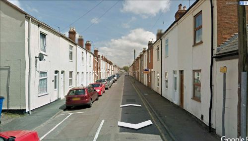
Robinhood Street in Gloucester connects Bristol and Seymour roads.
As far as IRHB is aware, this residential street is first recorded on a 6" O.S. map of the area published in 1884. On the next side street of Bristol Road, coming from the south, there was until 2008 a pub named the Robin Hood. By and large a pub is much more likely to bequeath its name to the street on which it is situated than the other way around, but it is hardly possible, without knowing the date when each arose, to say which was, as it were, the donor in this case where the name is shared with a neighbouring street.
Gazetteers
- Not included in Dobson, R. B., ed.; Taylor, J., ed. Rymes of Robyn Hood: an Introduction to the English Outlaw (London, 1976), pp. 293-311.
Maps
- 25" O.S. map Gloucestershire XXXIII.2 (1886; surveyed 1881–82)
- 25" O.S. map Gloucestershire XXXIII.2 (1902; rev. 1901) (georeferenced).
- 25" O.S. map Gloucestershire XXXIII.2 (1902; rev. 1901)
- 25" O.S. map Gloucestershire XXXIII.2 (1923; rev. 1921)
- 25" O.S. map Gloucestershire XXXIII.2 (1938; rev. 1936)
- 6" O.S. map Gloucestershire XXXIII.NW (1884; surveyed 1881–83)
- 6" O.S. map Gloucestershire XXXIII.NW (1903; rev. 1901) (georeferenced)
- 6" O.S. map Gloucestershire XXXIII.NW (1903; rev. 1901)
- 6" O.S. map Gloucestershire XXXIII (1924; rev. 1921)
- 6" O.S. map Gloucestershire XXXIII.NW (1924; rev. 1921)
- 6" O.S. map Gloucestershire XXXIII.NW (c. 1946; rev. 1938).
Also see

