
Robinhood Lane (Mitcham): Difference between revisions
m (Text replacement - "=== Notes ===" to "== Notes ==") |
m (Text replacement - "ImgGalleryIntro" to "ImageGalleryIntroduction") |
||
| (22 intermediate revisions by 2 users not shown) | |||
| Line 1: | Line 1: | ||
__NOTOC__{{ | __NOTOC__{{PlaceNamesItemTop|Lat=51.400976|Lon=-0.138228|AdministrativeDivision=Surrey|Vicinity=Near Pollards Hill in Mitcham; leading southeast from Manor Road; in area bounded by Manor Road, Sherwood Park Road and Wide Way|Type=Thoroughfare|Interest=Robin Hood name|Status=Extant|Demonym=|Riding=|GreaterLondon=Yes|Year=1936|Aka=|Century=|Cluster1=Mitcham|Cluster2=|Cluster3=|Image=robin-hood-lane-mitcham-google-earth-street-view-1.jpg|Postcards=|ExtraCat1=Robinhood place-names|ExtraCat2=|ExtraCat3 | ||
=|ExtraCat4=|ExtraCat5=|ExtraLink1=|ExtraLink2=|ExtraLink3=|ExtraLink4=|ExtraLink5=|ExtraLinkName1=|ExtraLinkName2=|ExtraLinkName3=|ExtraLinkName4=|ExtraLinkName5=|GeopointPrefix=|GeopointSuffix=|StatusSuffix=|DatePrefix=|DateSuffix=}} | =|ExtraCat4=|ExtraCat5=|ExtraLink1=|ExtraLink2=|ExtraLink3=|ExtraLink4=|ExtraLink5=|ExtraLinkName1=|ExtraLinkName2=|ExtraLinkName3=|ExtraLinkName4=|ExtraLinkName5=|GeopointPrefix=|GeopointSuffix=|StatusSuffix=|DatePrefix=|DateSuffix=}} | ||
{{#display_map:{{#var:Coords}}~{{#replace:{{PAGENAME}}|'|'}}|width=34%}}<div class="pnMapLegend">Robinhood Lane.</div> | {{#display_map:{{#var:Coords}}~{{#replace:{{PAGENAME}}|'|'}}|width=34%|enablefullscreen=yes}}<div class="pnMapLegend">Robinhood Lane.</div> | ||
[[File:{{#var: | [[File:{{#var:Image}}|thumb|right|500px|Robinhood Lane / Google Earth Street View.]]<div class="no-img"> | ||
<p id="byline">By Henrik Thiil Nielsen, 2017-11-29. Revised by {{#realname:{{REVISIONUSER}}}}, {{REVISIONYEAR}}-{{REVISIONMONTH}}-{{REVISIONDAY2}}.</p> | <p id="byline">By Henrik Thiil Nielsen, 2017-11-29. Revised by {{#realname:{{REVISIONUSER}}}}, {{REVISIONYEAR}}-{{REVISIONMONTH}}-{{REVISIONDAY2}}.</p> | ||
Robinhood Lane in Mitcham leads southwest from Manor Road in an area bounded by the latter, Sherwood Park Road and Wide Way. Northwest of Abbotts Road it is a proper street, but southwest of it passage is blocked by a green iron gate, and beyond the gate the lane is little more than a rut or footpath between gardens and garages, The earliest reference I have found is a 6" O.S. map published 1936, based on surveying done in 1932 (see Maps section below). Several streets in the vicinity have Robin Hood-related names. | Robinhood Lane in Mitcham leads southwest from Manor Road in an area bounded by the latter, Sherwood Park Road and Wide Way. Northwest of Abbotts Road it is a proper street, but southwest of it passage is blocked by a green iron gate, and beyond the gate the lane is little more than a rut or footpath between gardens and garages, The earliest reference I have found is a 6" O.S. map published 1936, based on surveying done in 1932 (see Maps section below). Several streets in the vicinity have Robin Hood-related names. | ||
{{ | {{PlaceNamesItemAllusionsAndRecords}} | ||
== Gazetteers == | == Gazetteers == | ||
* Not included in {{:Dobson, Richard Barrie 1976a}}, pp. 293-311. | * Not included in {{:Dobson, Richard Barrie 1976a}}, pp. 293-311. | ||
| Line 20: | Line 19: | ||
<!--== Background == | <!--== Background == | ||
* --> | * --> | ||
{{ | {{PlaceNamesItemAlsoSee}}<!-- | ||
== Notes == | == Notes == | ||
<references/>--> | <references/>--> | ||
</div> | |||
< | <div id="gallery"> | ||
{{ | {{ImageGalleryIntroduction}} | ||
<gallery widths="195px"> | <gallery widths="195px"> | ||
robin-hood-lane-mitcham-google-earth-street-view-1.jpg|On Robinhood Lane northwest of Abbotts Road, looking southeast / Google Earth Street View. | robin-hood-lane-mitcham-google-earth-street-view-1.jpg|On Robinhood Lane northwest of Abbotts Road, looking southeast / Google Earth Street View. | ||
robin-hood-lane-mitcham-google-earth-street-view-2.jpg|On Abbotts Road, looking southeast down Robinhood Lane / Google Earth Street View. | robin-hood-lane-mitcham-google-earth-street-view-2.jpg|On Abbotts Road, looking southeast down Robinhood Lane / Google Earth Street View. | ||
</gallery> | </gallery> | ||
</div> | |||
{{PlaceNamesItemNavigation}} | |||
{{ | |||
Latest revision as of 13:54, 7 January 2021
| Locality | |
|---|---|
| Coordinate | 51.400976, -0.138228 |
| Adm. div. | Surrey, now Greater London |
| Vicinity | Near Pollards Hill in Mitcham; leading southeast from Manor Road; in area bounded by Manor Road, Sherwood Park Road and Wide Way |
| Type | Thoroughfare |
| Interest | Robin Hood name |
| Status | Extant |
| First Record | 1936 |

By Henrik Thiil Nielsen, 2017-11-29. Revised by Henrik Thiil Nielsen, 2021-01-07.
Robinhood Lane in Mitcham leads southwest from Manor Road in an area bounded by the latter, Sherwood Park Road and Wide Way. Northwest of Abbotts Road it is a proper street, but southwest of it passage is blocked by a green iron gate, and beyond the gate the lane is little more than a rut or footpath between gardens and garages, The earliest reference I have found is a 6" O.S. map published 1936, based on surveying done in 1932 (see Maps section below). Several streets in the vicinity have Robin Hood-related names.
Gazetteers
- Not included in Dobson, R. B., ed.; Taylor, J., ed. Rymes of Robyn Hood: an Introduction to the English Outlaw (London, 1976), pp. 293-311.
Maps
- 6" O.S. map Surrey XIV (1872; surveyed 1867-68) (R. Lane not shown or labelled)
- 6" O.S. map Surrey XIV.NW (1898; rev. 1894-95) (R. Lane not shown or labelled)
- 6" O.S. map Surrey XIV.NW (1898; rev. 1894-95) (R. Lane not shown or labelled) (georeferenced)
- 6" O.S. map Surrey XIV.NW (1914; rev. 1910-11) (R. Lane not shown or labelled)
- 6" O.S. map Surrey XIV.NW (1936; rev. 1932) (R. Lane shown and labelled)
- 6" O.S. map Surrey XIV.NW (c. 1944; rev. 1938) (R. Lane shown and labelled)
- 6" O.S. map Surrey XIV.NW (1946; rev. 1938) (R. Lane shown and labelled)
Also see
Image gallery
Click any image to display it in the lightbox, where you can navigate between images by clicking in the right or left side of the current image.
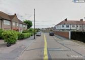
On Robinhood Lane northwest of Abbotts Road, looking southeast / Google Earth Street View.
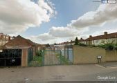
On Abbotts Road, looking southeast down Robinhood Lane / Google Earth Street View.
