Robinhood Meadow (Ilford)
| Locality | |
|---|---|
| Coordinate | 51.5594, 0.0797 |
| Adm. div. | Essex, now Greater London |
| Vicinity | S. side of High Road, E. of Riches Road, W. of Green Lane; extending about as far S. as Chamberlain Close |
| Type | Area |
| Interest | Robin Hood name |
| Status | Defunct |
| First Record | 1844 |
By Henrik Thiil Nielsen, 2018-02-17. Revised by Henrik Thiil Nielsen, 2021-02-12.
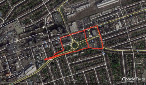
Robinhood Meadow is listed as a field name in the 1844 tithe award for Barking. The meadow was situated on the south side of Ilford High Road, extending east from the present Riches Road to present Green Lane and about as far south as present Chamberlain Close. It covered an area of 40316.81 m2. Its owner and occupier was a John Scrafton Thompson.[1]
The rough contours of the meadow are drawn in on one of the maps below. The area is entered in two parts in the tithe award, a fact I have attempted to reflect on the map. In addition to this, the long, narrow tongue extending left on the map is not part of the meadow proper but is entered separately from the two parts of the meadow as "Shrubbery (in Robinhood Meadow)", with an area of 581.74 m2, "Wood" as state of cultivation, and the same owner/occupier as the meadow.[2]
Two closes c. 500 m NE of Robinhood Meadow were named the Little Johns,
Gazetteers
- Not included in Dobson, R. B., ed.; Taylor, J., ed. Rymes of Robyn Hood: an Introduction to the English Outlaw (London, 1976), pp. 293-311.
MS sources
- Tithe award for Barking, online at the Genealogist, Piece 12, Sub-Piece 20, Image 112 (£)
- Tithe award for Barking, online at the Genealogist, Piece 12, Sub-Piece 20, Image 113 (£)
- Accompanying map, online at the Genealogist, Piece 12, Sub-Piece 20, Sub-Image 001 (£).
Maps
Maps of the area; Robinhood Meadow not labelled.
- 25" O.S. map Essex LXXIV.1 (1897; rev. 1894) (georeferenced)
- 6" O.S. map Essex LXXIV (1875; surveyed 1862)
- 6" O.S. map Essex LXXIV.NW (1898; rev. 1894) (georeferenced)
- 6" O.S. map Essex LXXIV.NW (1898; rev. 1894)
- 6" O.S. map London IV.SE (1894-96; rev. 1893-95)
- O.S. map London Sheet H (1914; rev. 1921)
- O.S. map London Sheet H (c. 1946; rev. 1938).
Background
Also see
Notes
- ↑ Tithe award for Barking, online at the Genealogist, Piece 12, Sub-Piece 20, Image 112, Nos. 1274 and 1274 a (£). Accompanying map, online at the Genealogist, Piece 12, Sub-Piece 20, Sub-Image 001 (£).
- ↑ Tithe award for Barking, online at the Genealogist, Piece 12, Sub-Piece 20, Image 113, Nos. 1275 (£). Accompanying map, online at the Genealogist, Piece 12, Sub-Piece 20, Sub-Image 001 (£).

