
Robinhood End Farm (Finchingfield): Difference between revisions
mNo edit summary |
m (Text replacement - "ImgGalleryIntro" to "ImageGalleryIntroduction") |
||
| (14 intermediate revisions by 2 users not shown) | |||
| Line 1: | Line 1: | ||
__NOTOC__{{ | __NOTOC__{{PlaceNamesItemTop|Lat=52.0047|Lon=0.4903|AdministrativeDivision=Essex|Vicinity=4.82 km NE of Finchingfield|Type=Building|Interest=Robin Hood name|Status=Extant|Demonym=|Riding=|GreaterLondon=|Year=1777|Aka=Robinhoodend Farm|Century=|Cluster1=Robinhood End|Cluster2=|Cluster3=|Image=Robinhood end farm finchampstead.jpg|Postcards=|ExtraCat1=|ExtraCat2=|ExtraCat3=|ExtraCat4=|ExtraCat5=|ExtraLink1=|ExtraLink2=|ExtraLink3=|ExtraLink4=|ExtraLink5=|ExtraLinkName1=|ExtraLinkName2=|ExtraLinkName3=|ExtraLinkName4=|ExtraLinkName5=|GeopointPrefix=|GeopointSuffix=|StatusSuffix=|DatePrefix=|DateSuffix=}} | ||
{{#display_map:{{#var:Coords}}~{{#replace:{{PAGENAME}}|'|'}}|controls=type,streetview|typestyle=dropdown|width=34% | {{#display_map:{{#var:Coords}}~{{#replace:{{PAGENAME}}|'|'}}|controls=type,streetview|typestyle=dropdown|width=34%|enablefullscreen=yes}}<div class="pnMapLegend">Robin Hood End Farm.</div> | ||
[[File:Chapman and andre 1777a rh farm and rhs end.jpg|thumb|right|500px|To the left, Robinhood End Farm ('Robin Hoods Farm') and Robin Hood End / From superb scan of entire map at [http://bvpb.mcu.es/ca/consulta/resultados_navegacion.cmd?posicion=1&forma=ficha&id=258 Biblioteca Virtual del Patrimoni Bibliogràfico] (click image to enlarge).]] | [[File:Chapman and andre 1777a rh farm and rhs end.jpg|thumb|right|500px|To the left, Robinhood End Farm ('Robin Hoods Farm') and Robin Hood End / From superb scan of entire map at [http://bvpb.mcu.es/ca/consulta/resultados_navegacion.cmd?posicion=1&forma=ficha&id=258 Biblioteca Virtual del Patrimoni Bibliogràfico] (click image to enlarge).]] | ||
[[File:Robinhood end farm finchampstead.jpg|thumb|right|500px|Robinhood End Farm / Google Earth Street View.]] | [[File:Robinhood end farm finchampstead.jpg|thumb|right|500px|Robinhood End Farm / Google Earth Street View.]]<div class="no-img"> | ||
<p id="byline">By Henrik Thiil Nielsen, 2016-06-25. Revised by {{#realname:{{REVISIONUSER}}}}, {{REVISIONYEAR}}-{{REVISIONMONTH}}-{{REVISIONDAY2}}.</p> | <p id="byline">By Henrik Thiil Nielsen, 2016-06-25. Revised by {{#realname:{{REVISIONUSER}}}}, {{REVISIONYEAR}}-{{REVISIONMONTH}}-{{REVISIONDAY2}}.</p> | ||
Robinhood End Farm in Stambourne parish<ref>{{:Reaney, Percy Hide 1969a}}, p. 456.</ref> is located 4.82 km NE of Finchingfield and ''c.'' 600 m NNE of the hamlet of [[Robinhood End (Finchingfield)|Robinhood End]]. This place-name is first known from Chapman and André's 1777 map of Essex (see Maps section below),<ref>{{:Reaney, Percy Hide 1969a}}, p. 457.</ref> where it appears as "Robin Hood Farm".<ref>'Robinhood Farm' in {{:Dobson, Richard Barrie 1976a}}, p. 297, ''s.n.'' Robinhood End Farm, is a mistake.</ref> On the 6" O.S. map of the area published in 1880 the locality is labelled "Robinhoodend Farm" [''sic''].<ref>[http://maps.nls.uk/view/102341822#zoom=6&lat=4716&lon=14667&layers=BT 6" O.S. map ''Essex'' X (1880, surveyed 1876-77)].</ref>{{PlaceNamesItemAllusionsAndRecords}} | |||
Robinhood End Farm in Stambourne parish<ref>{{:Reaney, Percy Hide 1969a}}, p. 456.</ref> is located 4.82 km NE of Finchingfield and ''c.'' 600 m NNE of the hamlet of [[Robinhood End (Finchingfield)|Robinhood End]]. This place-name is first known from Chapman and André's 1777 map of Essex (see Maps section below),<ref>{{:Reaney, Percy Hide 1969a}}, p. 457.</ref> where it appears as "Robin Hood Farm".<ref>'Robinhood Farm' in {{:Dobson, Richard Barrie 1976a}}, p. 297, ''s.n.'' Robinhood End Farm, is a mistake.</ref> On the 6" O.S. map of the area published in 1880 the locality is labelled "Robinhoodend Farm" [''sic''].<ref>[http://maps.nls.uk/view/102341822#zoom=6&lat=4716&lon=14667&layers=BT 6" O.S. map ''Essex'' X (1880, surveyed 1876-77)].</ref>{{ | |||
== Gazetteers == | == Gazetteers == | ||
* {{:Dobson, Richard Barrie 1976a}}, p. 297, ''s.n.'' Robinhood End Farm. | * {{:Dobson, Richard Barrie 1976a}}, p. 297, ''s.n.'' Robinhood End Farm. | ||
| Line 16: | Line 15: | ||
* [http://maps.nls.uk/view/102341822#zoom=6&lat=4716&lon=14667&layers=BT 6" O.S. map ''Essex'' X (1880, surveyed 1876-77)] | * [http://maps.nls.uk/view/102341822#zoom=6&lat=4716&lon=14667&layers=BT 6" O.S. map ''Essex'' X (1880, surveyed 1876-77)] | ||
* [http://maps.nls.uk/view/101455253#zoom=5&lat=5380&lon=7229&layers=BT 6" O.S. map ''Essex'' X.SE (1898, rev. 1896).] | * [http://maps.nls.uk/view/101455253#zoom=5&lat=5380&lon=7229&layers=BT 6" O.S. map ''Essex'' X.SE (1898, rev. 1896).] | ||
{{ | {{PlaceNamesItemAlsoSee}} | ||
== Notes == | == Notes == | ||
<references/> | <references/> | ||
</div> | |||
< | <div id="gallery"> | ||
{{ | {{ImageGalleryIntroduction}} | ||
<gallery widths="195px"> | <gallery widths="195px"> | ||
File:Robinhood end farm finchampstead.jpg|Robinhood End Farm / Google Earth Street View. | File:Robinhood end farm finchampstead.jpg|Robinhood End Farm / Google Earth Street View. | ||
File:Chapman and andre 1777a rh farm and rhs end.jpg|To the left, Robinhood End Farm ('Robin Hoods Farm') and Robin Hood End / From superb scan of entire map at [http://bvpb.mcu.es/ca/consulta/resultados_navegacion.cmd?posicion=1&forma=ficha&id=258 Biblioteca Virtual del Patrimoni Bibliogràfico] (click image to enlarge). | File:Chapman and andre 1777a rh farm and rhs end.jpg|To the left, Robinhood End Farm ('Robin Hoods Farm') and Robin Hood End / From superb scan of entire map at [http://bvpb.mcu.es/ca/consulta/resultados_navegacion.cmd?posicion=1&forma=ficha&id=258 Biblioteca Virtual del Patrimoni Bibliogràfico] (click image to enlarge). | ||
</gallery> | </gallery> | ||
</div> | |||
{{PlaceNamesItemNavigation}} | |||
{{ | |||
Latest revision as of 13:54, 7 January 2021
| Locality | |
|---|---|
| Coordinate | 52.0047, 0.4903 |
| Adm. div. | Essex |
| Vicinity | 4.82 km NE of Finchingfield |
| Type | Building |
| Interest | Robin Hood name |
| Status | Extant |
| First Record | 1777 |
| A.k.a. | Robinhoodend Farm |


By Henrik Thiil Nielsen, 2016-06-25. Revised by Henrik Thiil Nielsen, 2021-01-07.
Robinhood End Farm in Stambourne parish[1] is located 4.82 km NE of Finchingfield and c. 600 m NNE of the hamlet of Robinhood End. This place-name is first known from Chapman and André's 1777 map of Essex (see Maps section below),[2] where it appears as "Robin Hood Farm".[3] On the 6" O.S. map of the area published in 1880 the locality is labelled "Robinhoodend Farm" [sic].[4]
Gazetteers
- Dobson, R. B., ed.; Taylor, J., ed. Rymes of Robyn Hood: an Introduction to the English Outlaw (London, 1976), p. 297, s.n. Robinhood End Farm.
Sources
- Reaney, P.H. The Place-Names of Essex (English Place-Name Society, vol. XII) (Cambridge, 1969), p. 457; and see p. xl for Reaney's source;; p. 456 for the parish.
Maps
- Chapman, John, cartog.; André, Peter, cartog. A Map of the County of Essex: from an Actual Survey Taken in MDCCLXXII, LXXIII & MDCCLXXIV (London, 1777), plate III.
- 6" O.S. map Essex X (1880, surveyed 1876-77)
- 6" O.S. map Essex X.SE (1898, rev. 1896).
Also see
Notes
- ↑ Reaney, P.H. The Place-Names of Essex (English Place-Name Society, vol. XII) (Cambridge, 1969), p. 456.
- ↑ Reaney, P.H. The Place-Names of Essex (English Place-Name Society, vol. XII) (Cambridge, 1969), p. 457.
- ↑ 'Robinhood Farm' in Dobson, R. B., ed.; Taylor, J., ed. Rymes of Robyn Hood: an Introduction to the English Outlaw (London, 1976), p. 297, s.n. Robinhood End Farm, is a mistake.
- ↑ 6" O.S. map Essex X (1880, surveyed 1876-77).
Image gallery
Click any image to display it in the lightbox, where you can navigate between images by clicking in the right or left side of the current image.
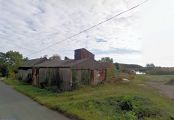
Robinhood End Farm / Google Earth Street View.
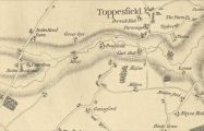
To the left, Robinhood End Farm ('Robin Hoods Farm') and Robin Hood End / From superb scan of entire map at Biblioteca Virtual del Patrimoni Bibliogràfico (click image to enlarge).