
Robinhood Alley (Milk Street): Difference between revisions
m (Text replacement - "{{#ask:[[Category:Records ({{#ifeq:{{#pos:{{PAGENAME}}|(|}}||{{PAGENAME}}|{{#sub:{{PAGENAME}}|0| {{#expr:{{#pos:{{PAGENAME}}|(|}}-1}} }},{{#sub:{{PAGENAME}}|{{#expr:{{#pos:{{PAGENAME}}|(|}}-1}}|1}}{{#sub:{{PAGENAME}}|{{#expr:{{#pos:...) |
m (Text replacement - "{{#display_map:{{#var:Coords}}~{{#replace:{{PAGENAME}}|'|'}}|width=34%}}<div class="pnMapLegend">" to "{{#display_map:{{#var:Coords}}~{{#replace:{{PAGENAME}}|'|'}}|width=34%|service=leaflet}}<div class="pnMapLegend">") |
||
| Line 1: | Line 1: | ||
__NOTOC__{{PnItemTop|Lat=51.5148961|Lon=-0.0937057|AdmDiv=Middlesex|Vicinity=Milk Street, ''c.'' 40 m N. of corner of Milk Street / Russia Row|Type=Thoroughfare|Interest=Robin Hood name| | __NOTOC__{{PnItemTop|Lat=51.5148961|Lon=-0.0937057|AdmDiv=Middlesex|Vicinity=Milk Street, ''c.'' 40 m N. of corner of Milk Street / Russia Row|Type=Thoroughfare|Interest=Robin Hood name| | ||
Status=Defunct|Demonym=English|Riding=|GreaterLondon=Yes|Year=1720|Aka=Robin Hood Alley; Robinhood Court; Robinhood-court; Robin Hood Court; Robinson's Court|Century=18|Cluster1=|Cluster2=|Cluster3=|Image=robinhood-alley-milk-street-locating-londons-past-street-view.jpg|Postcards=|ExtraCat1=Robinhood place-names|ExtraCat2=|ExtraCat3=|ExtraCat4=|ExtraCat5=|ExtraLink1=|ExtraLink2=|ExtraLink3=|ExtraLink4=|ExtraLink5=|ExtraLinkName1=|ExtraLinkName2=|ExtraLinkName3=|ExtraLinkName4=|ExtraLinkName5=|GeopointPrefix=|GeopointSuffix=|VicinitySuffix=|StatusSuffix=|DatePrefix=|DateSuffix=}} | Status=Defunct|Demonym=English|Riding=|GreaterLondon=Yes|Year=1720|Aka=Robin Hood Alley; Robinhood Court; Robinhood-court; Robin Hood Court; Robinson's Court|Century=18|Cluster1=|Cluster2=|Cluster3=|Image=robinhood-alley-milk-street-locating-londons-past-street-view.jpg|Postcards=|ExtraCat1=Robinhood place-names|ExtraCat2=|ExtraCat3=|ExtraCat4=|ExtraCat5=|ExtraLink1=|ExtraLink2=|ExtraLink3=|ExtraLink4=|ExtraLink5=|ExtraLinkName1=|ExtraLinkName2=|ExtraLinkName3=|ExtraLinkName4=|ExtraLinkName5=|GeopointPrefix=|GeopointSuffix=|VicinitySuffix=|StatusSuffix=|DatePrefix=|DateSuffix=}} | ||
{{#display_map:{{#var:Coords}}~{{#replace:{{PAGENAME}}|'|'}}|width=34%}}<div class="pnMapLegend">The corner of Milk Street and Robinhood Alley was very close to the point indicated on the map.</div> | {{#display_map:{{#var:Coords}}~{{#replace:{{PAGENAME}}|'|'}}|width=34%|service=leaflet}}<div class="pnMapLegend">The corner of Milk Street and Robinhood Alley was very close to the point indicated on the map.</div> | ||
[[File:{{#var:Pnimage}}|thumb|right|500px|The corner of Milk Street and Robinhood Alley was very close to where the pillar closest to the camera is now located / Google Earth Street View.]] | [[File:{{#var:Pnimage}}|thumb|right|500px|The corner of Milk Street and Robinhood Alley was very close to where the pillar closest to the camera is now located / Google Earth Street View.]] | ||
[[File:robinhood-alley-milk-street-locating-londons-past-map.jpg|thumb|right|500px|Robinhood Alley is shown but not labelled on John Rocque's 1746 map of London / [https://www.locatinglondon.org/ Locating London's Past.]]] | [[File:robinhood-alley-milk-street-locating-londons-past-map.jpg|thumb|right|500px|Robinhood Alley is shown but not labelled on John Rocque's 1746 map of London / [https://www.locatinglondon.org/ Locating London's Past.]]] | ||
Revision as of 09:01, 5 April 2019
[[File:|thumb|right|500px|The corner of Milk Street and Robinhood Alley was very close to where the pillar closest to the camera is now located / Google Earth Street View.]]

By Henrik Thiil Nielsen, 2018-01-18. Revised by Henrik Thiil Nielsen, 2019-04-05.
Listed in Harben's Dictionary of London under 'Robinhood Court' and by Dobson & Taylor as 'Robin Hood Court', the little street whose earliest known name was 'Robinhood Alley' ran "[e]ast out of Milk Street at No. 1, with a passage to Honey Lane Market. In Cheap Ward and Cripplegate Ward Within".[1]
Lockie's Topography (1810), which is the first source to use the name Robinhood Court, lists the locality as follows: "Robinhood-Court, Milk-Street, Cheapside,—two doors on the R. from Honey-lane-market, entering by 116, Cheapside."[2] The two passages in John Strype's survey of London and Westminster (1720) which include the first occurrence of any variant of this street name are included below in the Allusions section. According to Harben, Ogilby and Morgan's 1677 map of London labels the street 'Robinson's Court'. I have not been able to verify this as the copies of the map available online do not include any label for the street (see Maps section below for links). The street is labelled 'Robin Hood Al[ley] on Richard Horwood's map of London and Westminster (1792-99).[3]Template:PnItemQry
Gazetteers
- Dobson, R. B., ed.; Taylor, J., ed. Rymes of Robyn Hood: an Introduction to the English Outlaw (London, 1976), p. 299, s.n. Robin Hood Court [3]
- Elmes, James, compil. A Topographical Dictionary of London and Its Environs (London, 1831), p. 354 s.n. Robinhood-Ct.
- Harben, Henry A., compil.; [Greaves, I.I., ed.]. A Dictionary of London: Being Notes Topographical and Historical Relating to the Streets and Principal Buildings in the City of London (London, 1918), p. 505, s.nn. Robin Hood Alley, Robinhood Court [2], Robinson's Court
- Lockie, John, compil. Lockie's Topography of London, Giving a Concise Local Description of and Accurate Direction to Every Square, Street, Lane, Court, Dock, Wharf, Inn, Public Office, &c. in the Metropolis and its Environs (London, 1810), s,n. Robinhood-Court [5]
Maps
- Ogilby, John, cartog.; Morgan, William, cartog. Large and Accurate Map of the City of London ([s.l.], [1677])
- Rocque, John, cartog.; Pine, John, engr. A Plan of the Cities of London and Westminster, and Borough of Southwark (London, 1746) (R. Alley shown, not labelled)
- Richard Horwood's map of Westminster and London.
Notes
- ↑ Harben, Henry A., compil.; [Greaves, I.I., ed.]. A Dictionary of London: Being Notes Topographical and Historical Relating to the Streets and Principal Buildings in the City of London (London, 1918), p. 505, s.nn. Robin Hood Alley, Robinhood Court [2], Robinson's Court; Dobson, R. B., ed.; Taylor, J., ed. Rymes of Robyn Hood: an Introduction to the English Outlaw (London, 1976), p. 299, s.n. Robin Hood Court [3].
- ↑ Lockie, John, compil. Lockie's Topography of London, Giving a Concise Local Description of and Accurate Direction to Every Square, Street, Lane, Court, Dock, Wharf, Inn, Public Office, &c. in the Metropolis and its Environs (London, 1810), s,n. Robinhood-Court [5].
- ↑ See superb reproduction of map at Romantic London.
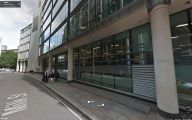
The corner of Milk Street and Robinhood Alley was very close to where the pillar closest to the camera is now located.
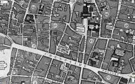
Robinhood Alley is shown but not labelled on John Rocque's 1746 map of London / Locating London's Past.
