
Robin Hood signpost (Bassenthwaite): Difference between revisions
m (Text replacement - "PnItemQry" to "PlaceNamesItemQuery") |
m (Text replacement - "PnItemNav" to "PlaceNamesItemNavigation") |
||
| Line 35: | Line 35: | ||
</div> | </div> | ||
{{ | {{PlaceNamesItemNavigation}} | ||
Revision as of 00:25, 6 January 2021
| Locality | |
|---|---|
| Coordinate | 54.691352, -3.197804 |
| Adm. div. | Cumberland |
| Vicinity | At intersection of the Rake and the road to Uldale; c. 1.5 km N of Bassenthwaite |
| Type | Artifact |
| Interest | Robin Hood name |
| Status | Extant |
| First Record | |
| A.k.a. | 1866 |

By Henrik Thiil Nielsen, 2020-07-14. Revised by Henrik Thiil Nielsen, 2021-01-06. Photo courtesy Jan Pedersen and Jill Boyes.
A signpost at the intersection of a road named 'The Rake' and the road to Uldale, c. 1.5 km N of Bassenthwaite, points to the hamlet of Robin Hood (Bassenthwaite), located c. 1.5 km to the south and c. 2 km NE of Bassenthwaite.
As early as 1866, OS maps of the area include the label 'Guide post' at this intersection, though on the SE corner and not on the N side of the Road to Uldale, opposite the Rake. Since the hamlet of Robin Hood (Bassenthwaite) was already in existence, the signpost likely also read 'Robin Hood' back then. Template:PlaceNamesItemQuery
Gazetteers
- Not included in Dobson, R. B., ed.; Taylor, J., ed. Rymes of Robyn Hood: an Introduction to the English Outlaw (London, 1976), pp. 293-311.
Maps
- 25" O.S. map Cumberland XLVI.12 (c. 1866; surveyed 1863)
- 25" O.S. map Cumberland XLVI.12 (1900; rev. 1898) (georeferenced)
- 25" O.S. map Cumberland XLVI.12 (1900; rev. 1898)
- 25" O.S. map Cumberland XLVI.12 (1925; rev. 1923)
- 6" O.S. map Cumberland XLVI (1867; surveyed 1864–65)
- 6" O.S. map Cumberland XLVI.SE (1900; rev. 1898) (georeferenced)
- 6" O.S. map Cumberland XLVI.SE (1900; rev. 1898)
- 6" O.S. map Cumberland XLVI.SE (1926; rev. 1923).
Background
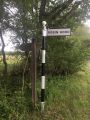
Sign pointing to teh hamlet of Robin Hood Holiday Park / Jan Pedersen and Jill Boyes, 8 July 2020.
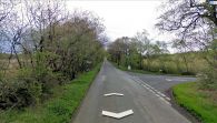
The signpost as it stands on the north side of the road to Uldale / Google Earth Street View.
