
Robin Hood pub sign (Clifton Reynes): Difference between revisions
mNo edit summary |
mNo edit summary |
||
| Line 1: | Line 1: | ||
__NOTOC__{{PnItemTop|Lat=52.152214|Lon=-0.681992|AdmDiv= | __NOTOC__{{PnItemTop|Lat=52.152214|Lon=-0.681992|AdmDiv=Buckinghamshire|Vicinity=Intersection of Newton and Clifton roads, immediately E of Clifton Reynes|Type=Miscellaneous|Interest=Artifacts|Status=Extant|Demonym=English|Riding=|GreaterLondon=|Year=|Aka=|Century=|Cluster1=Clifton Reynes|Cluster2=|Cluster3=|Image=robin-hood-pub-sign-clifton-reynes.jpg|Postcards=|ExtraCat1=|ExtraCat2=|ExtraCat3=|ExtraCat4=|ExtraCat5=|ExtraLink1=|ExtraLink2=|ExtraLink3=|ExtraLink4=|ExtraLink5=|ExtraLinkName1=|ExtraLinkName2=|ExtraLinkName3=|ExtraLinkName4=|ExtraLinkName5=|GeopointPrefix=|GeopointSuffix=|StatusSuffix=|DatePrefix=|DateSuffix=}} | ||
{{#display_map:{{#var:Coords}}~{{#replace:{{PAGENAME}}|'|'}}|width=34%}}<div class="pnMapLegend">Robin Hood Pub Sign, Clifton Reynes</div> | {{#display_map:{{#var:Coords}}~{{#replace:{{PAGENAME}}|'|'}}|width=34%}}<div class="pnMapLegend">Robin Hood Pub Sign, Clifton Reynes</div> | ||
[[File:{{#var:Pnimage}}|thumb|right|500px|Robin Hood pub sign, Clifton Reynes / Google Earth Street View.]] | [[File:{{#var:Pnimage}}|thumb|right|500px|Robin Hood pub sign, Clifton Reynes / Google Earth Street View.]] | ||
Revision as of 20:05, 20 October 2018
[[File:|thumb|right|500px|Robin Hood pub sign, Clifton Reynes / Google Earth Street View.]]
By Henrik Thiil Nielsen, 2018-10-20. Revised by Henrik Thiil Nielsen, 2018-10-20.
As the village of Clifton Reynes is situated at the end of a cul-de-sac, the sign of its Robin Hood pub has travelled to an intersection immediately east of the village in order to serve its purpose better. At this vantage point, a small sign below the painted signboard informs the traveller that he is just 359 paces, or about as many metres, from a drink.Template:PnItemQry
Gazetteers
- Not included in Dobson, R. B., ed.; Taylor, J., ed. Rymes of Robyn Hood: an Introduction to the English Outlaw (London, 1976), pp. 315-19.
Maps
- 25" O.S. map Buckinghamshire V.3 (1882; surveyed 1881)
- 25" O.S. map Buckinghamshire V.3 (1900; rev. 1899) (georeferenced)
- 25" O.S. map Buckinghamshire V.3 (1900; rev. 1899)
- 25" O.S. map Buckinghamshire V.3 (1925; rev. 1924)
- 6" O.S. map Buckinghamshire V (1885; surveyed 1881)
- 6" O.S. map Buckinghamshire V.NE (1900; rev. 1899)
- 6" O.S. map Buckinghamshire V.NE (1900; rev. 1899) (georeferenced)
- 6" O.S. map Buckinghamshire V.NE (1926; rev. 1924)
- 6" O.S. map Buckinghamshire V.NE (1952; rev. 1950).
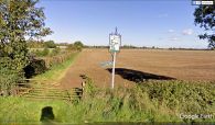
Robin Hood pub sign, Clifton Reynes / Google Earth Street View.
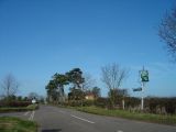
Intersection of Newton and Clifton roads with Robin Hood pub sign: 359 paces to the pub / Sian Harrison, 2 Mar. 2007, Creative Commons via Geograph.

