
Robin Hood pub sign (Clifton Reynes): Difference between revisions
mNo edit summary |
m (Text replacement - "ImgGalleryIntro" to "ImageGalleryIntroduction") |
||
| (18 intermediate revisions by 2 users not shown) | |||
| Line 1: | Line 1: | ||
__NOTOC__{{ | __NOTOC__{{PlaceNamesItemTop|Lat=52.152214|Lon=-0.681992|AdministrativeDivision=Buckinghamshire|Vicinity=Intersection of Newton and Clifton roads, immediately E of Clifton Reynes|Type=Miscellaneous|Interest=Artifacts|Status=Extant|Demonym=English|Riding=|GreaterLondon=|Year=|Aka=|Century=20|Cluster1=Clifton Reynes|Cluster2=|Cluster3=|Image=robin-hood-pub-sign-clifton-reynes.jpg|Postcards=|ExtraCat1=|ExtraCat2=|ExtraCat3=|ExtraCat4=|ExtraCat5=|ExtraLink1=|ExtraLink2=|ExtraLink3=|ExtraLink4=|ExtraLink5=|ExtraLinkName1=|ExtraLinkName2=|ExtraLinkName3=|ExtraLinkName4=|ExtraLinkName5=|GeopointPrefix=|GeopointSuffix=|StatusSuffix=|DatePrefix=|DateSuffix=}} | ||
{{#display_map:{{#var:Coords}}~{{#replace:{{PAGENAME}}|'|'}}|width=34%}}<div class="pnMapLegend">Robin Hood Pub Sign, Clifton Reynes</div> | {{#display_map:{{#var:Coords}}~{{#replace:{{PAGENAME}}|'|'}}|width=34%|enablefullscreen=yes}}<div class="pnMapLegend">Robin Hood Pub Sign, Clifton Reynes.</div> | ||
[[File:{{#var: | [[File:{{#var:Image}}|thumb|right|500px|Robin Hood pub sign, Clifton Reynes / Google Earth Street View.]]<div class="no-img"> | ||
<p id="byline">By Henrik Thiil Nielsen, 2018-10-20. Revised by {{#realname:{{REVISIONUSER}}}}, {{REVISIONYEAR}}-{{REVISIONMONTH}}-{{REVISIONDAY2}}.</p | <p id="byline">By Henrik Thiil Nielsen, 2018-10-20. Revised by {{#realname:{{REVISIONUSER}}}}, {{REVISIONYEAR}}-{{REVISIONMONTH}}-{{REVISIONDAY2}}.</p> | ||
As the village of Clifton Reynes is situated at the end of a cul-de-sac, the sign of its Robin Hood pub has travelled to an intersection immediately east of the village in order to serve its purpose better. At this vantage point, a small sign below the painted signboard informs the traveller that he is just 359 paces, or about as many metres, from a drink.{{ | As the village of Clifton Reynes is situated at the end of a cul-de-sac, the sign of its Robin Hood pub has travelled to an intersection immediately east of the village in order to serve its purpose better. At this vantage point, a small sign below the painted signboard informs the traveller that he is just 359 paces, or about as many metres, from a drink.{{PlaceNamesItemAllusionsAndRecords}} | ||
== Gazetteers == | == Gazetteers == | ||
| Line 21: | Line 21: | ||
== Background == | == Background == | ||
== Brief mention ==--> | == Brief mention ==--> | ||
{{ | {{PlaceNamesItemAlsoSee}} | ||
<!--== Notes == | <!--== Notes == | ||
<references/>--> | <references/>--> | ||
</div> | |||
< | <div id="gallery"> | ||
{{ | {{ImageGalleryIntroduction}} | ||
<gallery widths="195px"> | <gallery widths="195px"> | ||
robin-hood-pub-sign-clifton-reynes.jpg|Robin Hood pub sign, Clifton Reynes / Google Earth Street View. | robin-hood-pub-sign-clifton-reynes.jpg|Robin Hood pub sign, Clifton Reynes / Google Earth Street View. | ||
geograph-710561-by-sian-harrison.jpg|Intersection of Newton and Clifton roads with Robin Hood pub sign: 359 paces to the pub / [http://www.geograph.org.uk/photo/710561 Sian Harrison, 2 Mar. 2007, Creative Commons via Geograph.] | geograph-710561-by-sian-harrison.jpg|Intersection of Newton and Clifton roads with Robin Hood pub sign: 359 paces to the pub / [http://www.geograph.org.uk/photo/710561 Sian Harrison, 2 Mar. 2007, Creative Commons, via Geograph.] | ||
</gallery> | </gallery> | ||
</div> | |||
{{PlaceNamesItemNavigation}} | |||
{{ | |||
Latest revision as of 13:54, 7 January 2021
| Locality | |
|---|---|
| Coordinate | 52.152214, -0.681992 |
| Adm. div. | Buckinghamshire |
| Vicinity | Intersection of Newton and Clifton roads, immediately E of Clifton Reynes |
| Type | Miscellaneous |
| Interest | Artifacts |
| Status | Extant |
| First Record | |

By Henrik Thiil Nielsen, 2018-10-20. Revised by Henrik Thiil Nielsen, 2021-01-07.
As the village of Clifton Reynes is situated at the end of a cul-de-sac, the sign of its Robin Hood pub has travelled to an intersection immediately east of the village in order to serve its purpose better. At this vantage point, a small sign below the painted signboard informs the traveller that he is just 359 paces, or about as many metres, from a drink.
Gazetteers
- Not included in Dobson, R. B., ed.; Taylor, J., ed. Rymes of Robyn Hood: an Introduction to the English Outlaw (London, 1976), pp. 315-19.
Maps
- 25" O.S. map Buckinghamshire V.3 (1882; surveyed 1881)
- 25" O.S. map Buckinghamshire V.3 (1900; rev. 1899) (georeferenced)
- 25" O.S. map Buckinghamshire V.3 (1900; rev. 1899)
- 25" O.S. map Buckinghamshire V.3 (1925; rev. 1924)
- 6" O.S. map Buckinghamshire V (1885; surveyed 1881)
- 6" O.S. map Buckinghamshire V.NE (1900; rev. 1899)
- 6" O.S. map Buckinghamshire V.NE (1900; rev. 1899) (georeferenced)
- 6" O.S. map Buckinghamshire V.NE (1926; rev. 1924)
- 6" O.S. map Buckinghamshire V.NE (1952; rev. 1950).
Also see
Image gallery
Click any image to display it in the lightbox, where you can navigate between images by clicking in the right or left side of the current image.
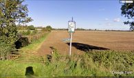
Robin Hood pub sign, Clifton Reynes / Google Earth Street View.
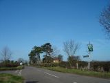
Intersection of Newton and Clifton roads with Robin Hood pub sign: 359 paces to the pub / Sian Harrison, 2 Mar. 2007, Creative Commons, via Geograph.
