
Robin Hood and Little John (St Clement Danes): Difference between revisions
(Created page with "__NOTOC__{{PnItemTop|Lat=51.513723|Lon=-0.113499|AdmDiv=Middlesex|Vicinity=South end of the Royal Courts of Justice|Type=Public house|Interest=Robin Hood name| Status=Defunct|...") |
mNo edit summary |
||
| Line 45: | Line 45: | ||
{{ImgGalleryIntro}} | {{ImgGalleryIntro}} | ||
<gallery widths="195px"> | <gallery widths="195px"> | ||
File:robin-hood-court-st-clement-danes-google-earth-street-view.jpg|thumb|right|500px|The Robin Hood | File:robin-hood-court-st-clement-danes-google-earth-street-view.jpg|thumb|right|500px|The Robin Hood and Little John was probably located somewhere within the area now occupied by the Royal Courts of Justice / Google Earth Street View. | ||
File:robin-hood-court-st-clement-danes-richard-horwood-romantic london.jpg|thumb|right|500px|Robin Hood | File:robin-hood-court-st-clement-danes-richard-horwood-romantic london.jpg|thumb|right|500px|The Robin Hood and Little John was probably located near the area indicated by the red arrow / Adapted from Richard Horwood's ''Plan of the Cities of London and Westminster'' (1792-99) at [http://www.romanticlondon.org/maps/fullscreen/layer/17/#18/51.51357/-0.11388 Romantic London.] | ||
</gallery> | </gallery> | ||
</div> | </div> | ||
{{PnItemNav}} | {{PnItemNav}} | ||
Revision as of 01:29, 12 June 2020
[[File:|thumb|right|500px|The Robin Hood and Little John was probably located somewhere within the area now occupied by the Royal Courts of Justice / Google Earth Street View.]]

By Henrik Thiil Nielsen, 2020-06-20. Revised by Henrik Thiil Nielsen, 2020-06-12.
Also known as the Robin Hood (Tavern) and the Robinhood, the Robin Hood and Little John was situated in a court on the north side of the stretch of the Strand where the main entrance to the Royal Courts of justice now are. It was famous as the meeting place of the Robin Hood Society.
The present precincts of the Royal Courts of Justice were a warren of gutters and 'courts' in the mid-18th century. One such street, Newastle Court, evidently had a 'sub-court' named 'Robin Hood Court' after a public house there which was known variously as the Robin Hood and Little, the Robin Hood Tavern, the Robin Hood tout court or the Robinhood. The members the of Societie for Free and Candyd Enquirie, established in 1613, had met for their weekly debating nights first at members' homes, later at a public house in Essex Street before finally moving to the Robin Hood in 1747,[1] and thereupon adopting the new or alternative name of the Robin Hood Society. Whiel IRHB has as yet found no reference to this pub dating from before 1747, it is clear from accounts of teh debating society that the pub was already well-established when it moved there.
See also the page on Robin Hood Court (St Clement Danes), for a more detailed discussion of the topography of the area, and the page on the Robin Hood Society. Template:PnItemQry
Gazetteers
- Not included in Dobson, R. B., ed.; Taylor, J., ed. Rymes of Robyn Hood: an Introduction to the English Outlaw (London, 1976), pp. 293-311.
Sources
Maps
- Locating London's Past (John Rocque's 1746 Map of London)
- Edward Stanford's Library Map of London (1862-71), Westminster section
- 25" O.S. map London (1915- Numbered sheets) V.10 (1936; rev. 1914)
- 25" O.S. map London (1915- Numbered sheets) V.10 (1936; rev. 1914) (georeferenced)
- 6" O.S. map Middlesex XVII (1880-82; surveyed 1868-73)
- 6" O.S. map Surrey III (1880; surveyed 1868-73)
- 6" O.S. map London VII.SW (1894-96; rev. 1893-95)
- 6" O.S. map Surrey III.NW (1898; rev. 1893-95)
- 6" O.S. map Surrey III.NW (1898; rev. 1893-95) (georeferenced)
- 6" O.S. map London Sheet K (1920; rev. 1913-14)
- 6" O.S. map London Sheet K (c. 1946; rev. 1938).
Background
Notes
- ↑ Anonymous. The History of the Robinhood Society. In which the Origin of that Illustrious Body of Men is traced; the Method of managing their Debates is shewn; the Memoirs of the Various Members that compose it are given; and some Original Speeches, as Specimens of their Oratorical Abilities, are recorded (London, 1764), pp. vii, 117.
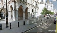
The Robin Hood and Little John was probably located somewhere within the area now occupied by the Royal Courts of Justice / Google Earth Street View.
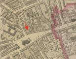
The Robin Hood and Little John was probably located near the area indicated by the red arrow / Adapted from Richard Horwood's Plan of the Cities of London and Westminster (1792-99) at Romantic London.
