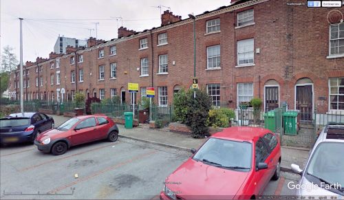
Robin Hood Terrace (Nottingham)
From International Robin Hood Bibliography
| Locality | |
|---|---|
| Coordinate | 52.957298, -1.139317 |
| Adm. div. | Nottinghamshire |
| Vicinity | Runs S from Scarborough Street; near St Mary's Rest Garden |
| Type | Thoroughfare |
| Interest | Robin Hood name |
| Status | Extant |
| First Record | 1901 |
Robin Hood Terrace.
By Henrik Thiil Nielsen, 2018-05-05. Revised by Henrik Thiil Nielsen, 2021-01-07.
Robin Hood Terrace in Nottingham runs south from Scarborough Street, a few meters east of St Mary's Rest Garden. It is located in a neighbourhood with a couple of other Robin Hood-related place-names. See Victoria Park (Nottingham) place-name cluster. Robin Hood Terrace is shown on all the 25" and 6" O.S. maps listed below but is only labelled on maps published 1901 or later.
Gazetteers
- Not included in Dobson, R. B., ed.; Taylor, J., ed. Rymes of Robyn Hood: an Introduction to the English Outlaw (London, 1976), pp. 293-311.
Maps
- 25" O.S. map Nottinghamshire XLII.2 (1881; surveyed 1881)
- 25" O.S. map Nottinghamshire XLII.2 (1901; rev. 1899)
- 25" O.S. map Nottinghamshire XLII.2 (1901; rev. 1899) (georeferenced)
- 25" O.S. map Nottinghamshire XLII.2 (1915; rev. 1913)
- 6" O.S. map Nottinghamshire XLII.NW (1885; surveyed 1880-81)
- 6" O.S. map Nottinghamshire XLII.NW (1901; rev. 1899)
- 6" O.S. map Nottinghamshire XLII.NW (1901; rev. 1899) (georeferenced)
- 6" O.S. map Nottinghamshire XLII.NW (1920; rev. 1919)
- 6" O.S. map Nottinghamshire XLII.NW (c. 1947; rev. 1918).
Also see

