Robin Hood Terrace (Ravenshead)
From International Robin Hood Bibliography
| Locality | |
|---|---|
| Coordinate | 53.093425, -1.155697 |
| Adm. div. | Nottinghamshire |
| Vicinity | Cul-de-sac on west side of Sandy Lane, a side road of Main Road in Ravenshead |
| Type | Thoroughfare |
| Interest | Robin Hood name |
| Status | Extant |
| First Record | |
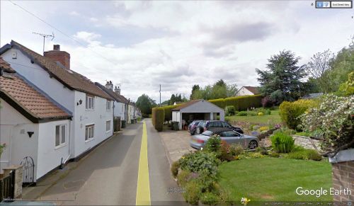
Robin Hood Terrace in Ravenshead.
By Henrik Thiil Nielsen, 2018-05-07. Revised by Henrik Thiil Nielsen, 2021-01-07.
Robin Hood Terrace is a residential cul-de-sac in Ravenshead. It may owe its name to the fact that it is located only about 50 m from a Little John Inn.
Robin Hood Terrace is shown without name on the O.S. maps listed below. Does the name date from the 20th century?
Gazetteers
- Not included in Dobson, R. B., ed.; Taylor, J., ed. Rymes of Robyn Hood: an Introduction to the English Outlaw (London, 1976), pp. 293-311.
Maps
- 25" O.S. map Nottinghamshire XXVIII.14 (1884; surveyed 1883)
- 25" O.S. map Nottinghamshire XXVIII.14 (1900; rev. 1898)
- 25" O.S. map Nottinghamshire XXVIII.14 (1900; rev. 1898) (georeferenced)
- 25" O.S. map Nottinghamshire XXVIII.14 (1915; rev. 1913)
- 6" O.S. map Nottinghamshire XXVIII.SW (1885; surveyed 1877-83)
- 6" O.S. map Nottinghamshire XXVIII.SW (1900; rev. 1897-98)
- 6" O.S. map Nottinghamshire XXVIII.SW (1900; rev. 1897-98) (georeferenced)
- 6" O.S. map Nottinghamshire XXVIII.SW (1920; rev. 1913)
- 6" O.S. map Nottinghamshire XXVIII.SW (c. 1949; rev. 1939).
Background
Also see

