Robin Hood Terrace (Nottingham): Difference between revisions
From International Robin Hood Bibliography
m (→Maps) |
m (Text replacement - "ImgGalleryIntro" to "ImageGalleryIntroduction") |
||
| (14 intermediate revisions by 2 users not shown) | |||
| Line 1: | Line 1: | ||
__NOTOC__{{ | __NOTOC__{{PlaceNamesItemTop|Lat=52.957298|Lon=-1.139317|AdministrativeDivision=Nottinghamshire|Vicinity=Runs S from Scarborough Street; near St Mary's Rest Garden|Type=Thoroughfare|Interest=Robin Hood name| | ||
Status=Extant|Demonym=English|Riding=|GreaterLondon=|Year=1901|Aka=|Century= 20|Cluster1=Victoria Park (Nottingham)|Cluster2=Nottingham|Cluster3=|Image=robin-hood-terrace-nottingham-google-earth-street-view.jpg|Postcards=|ExtraCat1=|ExtraCat2=|ExtraCat3=|ExtraCat4=|ExtraCat5=|ExtraLink1=|ExtraLink2=|ExtraLink3=|ExtraLink4=|ExtraLink5=|ExtraLinkName1=|ExtraLinkName2=|ExtraLinkName3=|ExtraLinkName4=|ExtraLinkName5=|GeopointPrefix=|GeopointSuffix=|VicinitySuffix=|StatusSuffix=|DatePrefix=|DateSuffix=}} | Status=Extant|Demonym=English|Riding=|GreaterLondon=|Year=1901|Aka=|Century= 20|Cluster1=Victoria Park (Nottingham)|Cluster2=Nottingham|Cluster3=|Image=robin-hood-terrace-nottingham-google-earth-street-view.jpg|Postcards=|ExtraCat1=|ExtraCat2=|ExtraCat3=|ExtraCat4=|ExtraCat5=|ExtraLink1=|ExtraLink2=|ExtraLink3=|ExtraLink4=|ExtraLink5=|ExtraLinkName1=|ExtraLinkName2=|ExtraLinkName3=|ExtraLinkName4=|ExtraLinkName5=|GeopointPrefix=|GeopointSuffix=|VicinitySuffix=|StatusSuffix=|DatePrefix=|DateSuffix=}} | ||
{{#display_map:{{#var:Coords}}~{{#replace:{{PAGENAME}}|'|'}}|width=34% | {{#display_map:{{#var:Coords}}~{{#replace:{{PAGENAME}}|'|'}}|width=34%|enablefullscreen=yes}}<div class="pnMapLegend">Robin Hood Terrace.</div> | ||
[[File:{{#var: | [[File:{{#var:Image}}|thumb|right|500px|Robin Hood Terrace / Google Earth Street View.]]<div class="no-img"> | ||
<p id="byline">By Henrik Thiil Nielsen, 2018-05-05. Revised by {{#realname:{{REVISIONUSER}}}}, {{REVISIONYEAR}}-{{REVISIONMONTH}}-{{REVISIONDAY2}}.</p | <p id="byline">By Henrik Thiil Nielsen, 2018-05-05. Revised by {{#realname:{{REVISIONUSER}}}}, {{REVISIONYEAR}}-{{REVISIONMONTH}}-{{REVISIONDAY2}}.</p> | ||
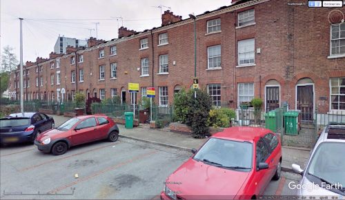
Robin Hood Terrace in Nottingham runs south from Scarborough Street, a few meters east of St Mary's Rest Garden. It is located in a neighbourhood with a couple of other Robin Hood-related place-names. See [[Victoria Park (Nottingham) place-name cluster]]. Robin Hood Terrace is shown on all the 25" and 6" O.S. maps listed below but is only labelled on maps published 1901 or later.{{ | Robin Hood Terrace in Nottingham runs south from Scarborough Street, a few meters east of St Mary's Rest Garden. It is located in a neighbourhood with a couple of other Robin Hood-related place-names. See [[Victoria Park (Nottingham) place-name cluster]]. Robin Hood Terrace is shown on all the 25" and 6" O.S. maps listed below but is only labelled on maps published 1901 or later.{{PlaceNamesItemAllusionsAndRecords}} | ||
== Gazetteers == | == Gazetteers == | ||
* Not included in {{:Dobson, Richard Barrie 1976a}}, pp. 293-311. | * Not included in {{:Dobson, Richard Barrie 1976a}}, pp. 293-311. | ||
| Line 25: | Line 25: | ||
<!--== Brief mention == | <!--== Brief mention == | ||
* --> | * --> | ||
{{ | {{PlaceNamesItemAlsoSee}}<!-- | ||
== Notes == | == Notes == | ||
<references/>--> | <references/>--> | ||
</div> | |||
<!--<div id="gallery"> | |||
{{ImageGalleryIntroduction}} | |||
{{ | |||
<gallery widths="195px"> | <gallery widths="195px"> | ||
FOR EACH IMAGE: File:_FILENAME.jpg|_LEGEND / [_URL _PHOTOGRAPHER, _DAY _MON. _YEAR, Creative Commons.] | FOR EACH IMAGE: File:_FILENAME.jpg|_LEGEND / [_URL _PHOTOGRAPHER, _DAY _MON. _YEAR, Creative Commons.] | ||
</gallery>--> | </gallery> | ||
</div>--> | |||
{{ | {{PlaceNamesItemNavigation}} | ||
Latest revision as of 13:53, 7 January 2021
| Locality | |
|---|---|
| Coordinate | 52.957298, -1.139317 |
| Adm. div. | Nottinghamshire |
| Vicinity | Runs S from Scarborough Street; near St Mary's Rest Garden |
| Type | Thoroughfare |
| Interest | Robin Hood name |
| Status | Extant |
| First Record | 1901 |
Robin Hood Terrace.
By Henrik Thiil Nielsen, 2018-05-05. Revised by Henrik Thiil Nielsen, 2021-01-07.
Robin Hood Terrace in Nottingham runs south from Scarborough Street, a few meters east of St Mary's Rest Garden. It is located in a neighbourhood with a couple of other Robin Hood-related place-names. See Victoria Park (Nottingham) place-name cluster. Robin Hood Terrace is shown on all the 25" and 6" O.S. maps listed below but is only labelled on maps published 1901 or later.
Gazetteers
- Not included in Dobson, R. B., ed.; Taylor, J., ed. Rymes of Robyn Hood: an Introduction to the English Outlaw (London, 1976), pp. 293-311.
Maps
- 25" O.S. map Nottinghamshire XLII.2 (1881; surveyed 1881)
- 25" O.S. map Nottinghamshire XLII.2 (1901; rev. 1899)
- 25" O.S. map Nottinghamshire XLII.2 (1901; rev. 1899) (georeferenced)
- 25" O.S. map Nottinghamshire XLII.2 (1915; rev. 1913)
- 6" O.S. map Nottinghamshire XLII.NW (1885; surveyed 1880-81)
- 6" O.S. map Nottinghamshire XLII.NW (1901; rev. 1899)
- 6" O.S. map Nottinghamshire XLII.NW (1901; rev. 1899) (georeferenced)
- 6" O.S. map Nottinghamshire XLII.NW (1920; rev. 1919)
- 6" O.S. map Nottinghamshire XLII.NW (c. 1947; rev. 1918).
Also see

