Robin Hood Lane (Poplar): Difference between revisions
m (Text replacement - "AdmDiv" to "AdministrativeDivision") |
m (Text replacement - "PnItemTop" to "PlaceNamesItemTop") |
||
| Line 1: | Line 1: | ||
__NOTOC__{{ | __NOTOC__{{PlaceNamesItemTop|Lat=51.51007273777175|Lon=-0.007367022335529327|AdministrativeDivision=Middlesex|Vicinity=Between Ashton Street and Poplar High Street; W of N entrance to Blackwall Tunnel|Type=Thoroughfare|Interest=Robin Hood name| | ||
Status=Extant|Demonym=|Riding=|GreaterLondon=Yes|Year=1703|Aka=Robinhood-lane|Century=18|Cluster1=Poplar|Cluster2=|Cluster3=|Image=robin-hood-lane-poplar-google-earth-street-view.jpg|Postcards=|ExtraCat1=Robinhood place-names|ExtraCat2=|ExtraCat3=|ExtraCat4=|ExtraCat5=|ExtraLink1=|ExtraLink2=|ExtraLink3=|ExtraLink4=|ExtraLink5=|ExtraLinkName1=|ExtraLinkName2=|ExtraLinkName3=|ExtraLinkName4=|ExtraLinkName5=|GeopointPrefix=|GeopointSuffix=|VicinitySuffix=|StatusSuffix=|DatePrefix=|DateSuffix=}} | Status=Extant|Demonym=|Riding=|GreaterLondon=Yes|Year=1703|Aka=Robinhood-lane|Century=18|Cluster1=Poplar|Cluster2=|Cluster3=|Image=robin-hood-lane-poplar-google-earth-street-view.jpg|Postcards=|ExtraCat1=Robinhood place-names|ExtraCat2=|ExtraCat3=|ExtraCat4=|ExtraCat5=|ExtraLink1=|ExtraLink2=|ExtraLink3=|ExtraLink4=|ExtraLink5=|ExtraLinkName1=|ExtraLinkName2=|ExtraLinkName3=|ExtraLinkName4=|ExtraLinkName5=|GeopointPrefix=|GeopointSuffix=|VicinitySuffix=|StatusSuffix=|DatePrefix=|DateSuffix=}} | ||
{{#display_map:{{#var:Coords}}~{{#replace:{{PAGENAME}}|'|'}}|width=34%|enablefullscreen=yes}}<div class="pnMapLegend">Robin Hood Lane, Poplar.</div> | {{#display_map:{{#var:Coords}}~{{#replace:{{PAGENAME}}|'|'}}|width=34%|enablefullscreen=yes}}<div class="pnMapLegend">Robin Hood Lane, Poplar.</div> | ||
Revision as of 23:59, 5 January 2021
| Locality | |
|---|---|
| Coordinate | 51.510073, -0.007367 |
| Adm. div. | Middlesex, now Greater London |
| Vicinity | Between Ashton Street and Poplar High Street; W of N entrance to Blackwall Tunnel |
| Type | Thoroughfare |
| Interest | Robin Hood name |
| Status | Extant |
| First Record | 1703 |
| A.k.a. | Robinhood-lane |
By Henrik Thiil Nielsen, 2017-12-28. Revised by Henrik Thiil Nielsen, 2021-01-05.
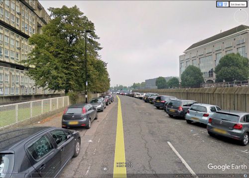
Robin Hood Lane in Poplar is first recorded on Joel Gascoyne's 1703 map of Stepney (see Maps section below).[1] Since 1966 it has been home to a controversial 'brutalist' concrete housing project named Robin Hood Gardens, which is now being torn down.
Robin Hood Lane figures not infrequently in reports of cases at the Old Bailey (see Records below). It is included in the list of London street and place-names in the Compleat Compting-House Companion (1763).[2] Lockie in his Topography of London (1810) lists it as "Robinhood-Lane, Poplar,—at the E. end of Polar-High-st. or road, on the L. extending to the East-India dock-gate" (see Gazetteers below). Template:PnItemQry
Gazetteers
Sources
- Anonymous. The Compleat Compting-House Companion: or, Young Merchant, or Tradesman's Sure Guide (London, 1763), p. 418 s.n. Robin Hood lane
- Anonymous, compil. The New Complete Guide to all Persons who have any Trade or Concern with the City of London, and Parts adjacent ([s.l], 1783), p. 59 s.n. Robin Hood lane
- Gover, J.E.B.; Mawer, Allen; Stenton, F.M.; Madge, S.J. The Place-Names of Middlesex apart from the City of London (English Place-Name Society, vol. XVIII) (Cambridge, 1942), p. 137, and p. xx for source reference
- Lockie, John, compil. Lockie's Topography of London, Giving a Concise Local Description of and Accurate Direction to Every Square, Street, Lane, Court, Dock, Wharf, Inn, Public Office, &c. in the Metropolis and its Environs (London, 1810), s.n. Robinhood Lane
Maps
- Gascoyne, Joel, cartog.; Harris, John, engr. An Actuall Survey of the Parish of St Dunstan Stepney alias Stebunheath ([London], 1703)
- Gascoyne, Joel, cartog.; Harris, John, engr. An Actuall Survey of the Parish of St. Dunstan Stepney, Alias Stebunheath: Being One of the Ten Paryshes in the County of Middlesex Adjacent to the City of London ([London], [1994?])
- British Library: Online Gallery; section, including Robin Hood Lane, as an overlay on Google Maps
- Daniel Crouch Rare Books Eastenders; entire map (reduced size)
- 25" O.S. map London (1869; surveyed 1867)
- 25" O.S. map Essex (1916; rev. 1914)
- 25" O.S. map Essex LXXXVI.9 (1916; rev. 1914) (georeferenced)
- 6" O.S. map Essex LXXXI (1870-82; surveyed 1862-73)
- 6" O.S. map Middlesex XVIII (1873; surveyed 1867)
- 6" O.S. map Surrey III (1880; surveyed 1868-73)
- 6" O.S. map London VIII.SW (1894-96; rev. 1893-94)
- 6" O.S. map Surrey III.NE (1898; rev. 1893-94)
- 6" O.S. map Essex LXXXI.NW (1899; rev. 1893-94)
- 6" O.S. map Kent I.NE (1899; rev. 1893-94)
- 6" O.S. map 'Kent' I.NE (1899; rev. 1893-94) (georeferenced)
- 6" O.S. map London Sheet L (1920; rev. 1913-15)
- 6" O.S. map London Sheet L (c. 1946; rev. 1938).
Background
Notes
- ↑ Cf. also Gover, J.E.B.; Mawer, Allen; Stenton, F.M.; Madge, S.J. The Place-Names of Middlesex apart from the City of London (English Place-Name Society, vol. XVIII) (Cambridge, 1942), p. 137, and p. xx for source reference.
- ↑ Anonymous. The Compleat Compting-House Companion: or, Young Merchant, or Tradesman's Sure Guide (London, 1763), p. 418 s.n. Robin Hood lane.

