
Robin Hood Court (St Clement Danes)
[[File:|thumb|right|500px|The Robin Hood Court was probably located somewhere within the area now occupied by the Royal Courts of Justice / Google Earth Street View.]]

By Henrik Thiil Nielsen, 2018-06-23. Revised by Henrik Thiil Nielsen, 2018-07-12.
Robin Hood Court was located a little north-east of the church of St Clement Danes in an area now occupied by the Royal Courts of Justice. It is noted in mid-18th to early 19th century topographical reference works on London.
Robin Hood Court is included in a list of localities in the Compleat Compting House Companion (1763).[1] Lockie in his Topography of London (editions of 1810 and 1813) notes a ""Robinhood-Court, Newcastle-Court, Strand,—the first on the L., a few yards from Picket-st. or the Strand, near Temple-bar" (see Gazetteers below). "Picket Street" was then the name of the Strand on the north side of the church of St Clement Danes.[2] Based on Lockie's directions I believe the yard indicated on the detail of Horwood's map below is likely to be the one he referred to.
Gazetteers
- Anonymous. The Compleat Compting-House Companion: or, Young Merchant, or Tradesman's Sure Guide (London, 1763), p. 417, s.n. Robin Hood court [6]
- Anonymous, compil. The New Complete Guide to all Persons who have any Trade or Concern with the City of London, and Parts adjacent ([s.l], 1783), p. 59 s.n. Robin Hood's court [6]
- Not included in Dobson, R. B., ed.; Taylor, J., ed. Rymes of Robyn Hood: an Introduction to the English Outlaw (London, 1976), pp. 293-311
- Elmes, James, compil. A Topographical Dictionary of London and Its Environs (London, 1831), p. 354, s.n. Robinhood-Ct.
- Lockie, John, compil. Lockie's Topography of London, Giving a Concise Local Description of and Accurate Direction to Every Square, Street, Lane, Court, Dock, Wharf, Inn, Public Office, &c. in the Metropolis and its Environs (London, 1810), s.n. Robinhood-Court [2]
Maps
- Edward Stanford's Library Map of London (1862-71), Westminster section
- 25" O.S. map London (1915- Numbered sheets) V.10 (1936; rev. 1914)
- 25" O.S. map London (1915- Numbered sheets) V.10 (1936; rev. 1914) (georeferenced)]
- 6" O.S. map Middlesex XVII (1880-82; surveyed 1868-73)
- 6" O.S. map Surrey III (1880; surveyed 1868-73)
- 6" O.S. map London VII.SW (1894-96; rev. 1893-95)
- 6" O.S. map Surrey III.NW (1898; rev. 1893-95)
- 6" O.S. map Surrey III.NW (1898; rev. 1893-95) (georeferenced)
- 6" O.S. map London Sheet K (1920; rev. 1913-14)
- 6" O.S. map London Sheet K (c. 1946; rev. 1938).
Background
Notes
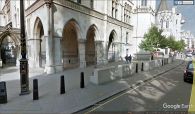
The Robin Hood Court was probably located somewhere within the area now occupied by the Royal Courts of Justice / Google Earth Street View.
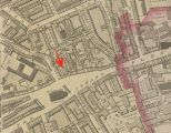
Robin Hood Court was probably the area indicated by the red arrow / Adapted from Richard Horwood's Plan of the Cities of London and Westminster (1792-99) at Romantic London.
