
Robin Hood Court (Golden Lane)
[[File:|thumb|right|500px|On Fann Street, just north of the Presbyterian Church of Wales. This area may once have been named Robin Hood Court / Google Earth Street View.]]

By Henrik Thiil Nielsen, 2018-06-24. Revised by Henrik Thiil Nielsen, 2019-04-05.
Somewhere between Golden Lane and Goswell Road, then named Goswell Street, was a yard or cul-de-sac named Robin Hood Court in the mid-18th to early 19th century. It is listed in a few topographical handbooks of the period but apparently not included on any maps.
Robin Hood Court is included in a list of localities in the Compleat Compting House Companion (1763)[1] and the New Complete Guide (1783).[2] John Lockie in his Topography of London lists it as "Robinhood-Court, Bell-Alley, Golden-Lane,—the third on the R. from Golden-lane, towards Goswell-street". Bell-Alley led away from Golden Lane at a ninety-degree angle, then turned roughly north to run parallel to Golden Lane, then again turned ninety degrees towards Goswell Road. Somewhere along the route was Robin Hood Court. I have indicated a possible location on the detail of Richard Horwood's map of London (1792-99) below, but this is quite tentative.Template:PnItemQry
Gazetteers
- Anonymous. The Compleat Compting-House Companion: or, Young Merchant, or Tradesman's Sure Guide (London, 1763), p. 417, s.n. Robin Hood court [1]
- Anonymous, compil. The New Complete Guide to all Persons who have any Trade or Concern with the City of London, and Parts adjacent ([s.l], 1783), p. 59 s.n. Robin Hood's court [1].
- Not included in Dobson, R. B., ed.; Taylor, J., ed. Rymes of Robyn Hood: an Introduction to the English Outlaw (London, 1976), pp. 293-311
- Elmes, James, compil. A Topographical Dictionary of London and Its Environs (London, 1831), p. 354, s.n. Robinhood-Ct.
- Lockie, John, compil. Lockie's Topography of London, Giving a Concise Local Description of and Accurate Direction to Every Square, Street, Lane, Court, Dock, Wharf, Inn, Public Office, &c. in the Metropolis and its Environs (London, 1810), s.n. Robinhood-Court [6]
Maps
- Horwood, Richard, cartog. Plan of the Cities of London and Westminster, the Borough of Southwark, and Parts adjoining Shewing every House (London, 1792-99)
- 25" O.S. map London (1915- Numbered sheets) V.10 (1936; rev. 1914)
- 25" O.S. map London (1915- Numbered sheets) V.10 (1936; rev. 1914) (georeferenced)]
- 6" O.S. map Middlesex XVII (1880-82; surveyed 1868-73)
- 6" O.S. map Surrey III (1880; surveyed 1868-73)
- 6" O.S. map London VII.SW (1894-96; rev. 1893-95)
- 6" O.S. map Surrey III.NW (1898; rev. 1893-95)
- 6" O.S. map Surrey III.NW (1898; rev. 1893-95) (georeferenced)
- 6" O.S. map London Sheet K (1920; rev. 1913-14)
- 6" O.S. map London Sheet K (c. 1946; rev. 1938).
Notes
- ↑ Anonymous. The Compleat Compting-House Companion: or, Young Merchant, or Tradesman's Sure Guide (London, 1763), p. 417, s.n. Robin Hood court [1].
- ↑ Anonymous, compil. The New Complete Guide to all Persons who have any Trade or Concern with the City of London, and Parts adjacent ([s.l], 1783), p. 59 s.n. Robin Hood's court [1].
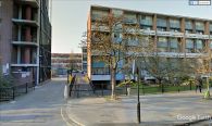
On Fann Street, just north of the Presbyterian Church of Wales. This area may once have been named Robin Hood Court / Google Earth Street View.
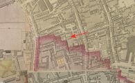
The area indicated by the red arrow was perhaps named Robin Hood Court in the early 19th century / Romantic London: Richard Horwood's map of London.
