
Robin Hood Court (Golden Lane): Difference between revisions
m (Text replacement - "|service=leaflet}}" to "|service=leaflet|enablefullscreen=yes}}") |
m (Text replacement - "ImgGalleryIntro" to "ImageGalleryIntroduction") |
||
| (15 intermediate revisions by 2 users not shown) | |||
| Line 1: | Line 1: | ||
__NOTOC__{{ | __NOTOC__{{PlaceNamesItemTop|Lat=51.521910|Lon=-0.095528|AdministrativeDivision=Middlesex|Vicinity=Perhaps a few meters N of Fann Street, ''c.'' 75 meters W of Golden Lane|Type=Area|Interest=Robin Hood name| | ||
Status=Defunct|Demonym=|Riding=|GreaterLondon=Yes|Year=1810|Aka=Robinhood-Court|Century=|Cluster1=|Cluster2=|Cluster3=|Image=robin-hood-golden-lane-google-earth-street-view.jpg|Postcards=|ExtraCat1=Robinhood place-names|ExtraCat2=|ExtraCat3=|ExtraCat4=|ExtraCat5=|ExtraLink1=|ExtraLink2=|ExtraLink3=|ExtraLink4=|ExtraLink5=|ExtraLinkName1=|ExtraLinkName2=|ExtraLinkName3=|ExtraLinkName4=|ExtraLinkName5=|GeopointPrefix=Near |GeopointSuffix=?|VicinitySuffix=|StatusSuffix=|DatePrefix=|DateSuffix=}} | Status=Defunct|Demonym=|Riding=|GreaterLondon=Yes|Year=1810|Aka=Robinhood-Court|Century=|Cluster1=|Cluster2=|Cluster3=|Image=robin-hood-golden-lane-google-earth-street-view.jpg|Postcards=|ExtraCat1=Robinhood place-names|ExtraCat2=|ExtraCat3=|ExtraCat4=|ExtraCat5=|ExtraLink1=|ExtraLink2=|ExtraLink3=|ExtraLink4=|ExtraLink5=|ExtraLinkName1=|ExtraLinkName2=|ExtraLinkName3=|ExtraLinkName4=|ExtraLinkName5=|GeopointPrefix=Near |GeopointSuffix=?|VicinitySuffix=|StatusSuffix=|DatePrefix=|DateSuffix=}} | ||
{{#display_map:{{#var:Coords}}~{{#replace:{{PAGENAME}}|'|'}}|width=34% | {{#display_map:{{#var:Coords}}~{{#replace:{{PAGENAME}}|'|'}}|width=34%|enablefullscreen=yes}}<div class="pnMapLegend">Robin Hood Court was perhaps near the point indicated.</div> | ||
[[File:{{#var: | [[File:{{#var:Image}}|thumb|right|500px|On Fann Street, just north of the Presbyterian Church of Wales. This area may once have been named Robin Hood Court / Google Earth Street View.]] | ||
[[File:robin-hood-golden-lane-richard-horwood-romantic-london.jpg|thumb|right|500px|The area indicated by the red arrow was perhaps named Robin Hood Court in the early 19th century / [http://www.romanticlondon.org/maps/fullscreen/layer/17/#18/51.52170/-0.09537 Romantic London: Richard Horwood's map of London.]]] | [[File:robin-hood-golden-lane-richard-horwood-romantic-london.jpg|thumb|right|500px|The area indicated by the red arrow was perhaps named Robin Hood Court in the early 19th century / [http://www.romanticlondon.org/maps/fullscreen/layer/17/#18/51.52170/-0.09537 Romantic London: Richard Horwood's map of London.]]]<div class="no-img"> | ||
<p id="byline">By Henrik Thiil Nielsen, 2018-06-24. Revised by {{#realname:{{REVISIONUSER}}}}, {{REVISIONYEAR}}-{{REVISIONMONTH}}-{{REVISIONDAY2}}.</p | <p id="byline">By Henrik Thiil Nielsen, 2018-06-24. Revised by {{#realname:{{REVISIONUSER}}}}, {{REVISIONYEAR}}-{{REVISIONMONTH}}-{{REVISIONDAY2}}.</p> | ||
Somewhere between Golden Lane and Goswell Road, then named Goswell Street, was a yard or cul-de-sac named Robin Hood Court in the mid-18th to early 19th century. It is listed in a few topographical handbooks of the period but apparently not included on any maps. | Somewhere between Golden Lane and Goswell Road, then named Goswell Street, was a yard or cul-de-sac named Robin Hood Court in the mid-18th to early 19th century. It is listed in a few topographical handbooks of the period but apparently not included on any maps. | ||
Robin Hood Court is included in a list of localities in the ''Compleat Compting House Companion'' (1763)<ref>{{:Anonymous 1763a}}, p. 417, ''s.n.'' Robin Hood court [1].</ref> and the ''New Complete Guide'' (1783).<ref>{{:Anonymous 1783a}}, p. 59 ''s.n.'' Robin Hood's court [1].</ref> John Lockie in his ''Topography of London'' lists it as "Robinhood-Court, Bell-Alley, Golden-Lane,—the third on the R. from Golden-lane, towards Goswell-street". Bell-Alley led away from Golden Lane at a ninety-degree angle, then turned roughly north to run parallel to Golden Lane, then again turned ninety degrees towards Goswell Road. Somewhere along the route was Robin Hood Court. I have indicated a possible location on the detail of Richard Horwood's map of London (1792-99) below, but this is quite tentative.{{ | Robin Hood Court is included in a list of localities in the ''Compleat Compting House Companion'' (1763)<ref>{{:Anonymous 1763a}}, p. 417, ''s.n.'' Robin Hood court [1].</ref> and the ''New Complete Guide'' (1783).<ref>{{:Anonymous 1783a}}, p. 59 ''s.n.'' Robin Hood's court [1].</ref> John Lockie in his ''Topography of London'' lists it as "Robinhood-Court, Bell-Alley, Golden-Lane,—the third on the R. from Golden-lane, towards Goswell-street". Bell-Alley led away from Golden Lane at a ninety-degree angle, then turned roughly north to run parallel to Golden Lane, then again turned ninety degrees towards Goswell Road. Somewhere along the route was Robin Hood Court. I have indicated a possible location on the detail of Richard Horwood's map of London (1792-99) below, but this is quite tentative. | ||
{{PlaceNamesItemAllusionsAndRecords}} | |||
== Gazetteers == | == Gazetteers == | ||
* Not included in {{:Dobson, Richard Barrie 1976a}}, pp. 293-311. | |||
== Sources == | |||
* {{:Anonymous 1763a}}, p. 417, ''s.n.'' Robin Hood court [1] | * {{:Anonymous 1763a}}, p. 417, ''s.n.'' Robin Hood court [1] | ||
* {{:Anonymous 1783a}}, p. 59 ''s.n.'' Robin Hood's court [1] | * {{:Anonymous 1783a}}, p. 59 ''s.n.'' Robin Hood's court [1] | ||
* {{:Elmes, James 1831a}}, p. 354, ''s.n.'' Robinhood-Ct. | * {{:Elmes, James 1831a}}, p. 354, ''s.n.'' Robinhood-Ct. | ||
* {{:Lockie, John 1810a}}, ''s.n.'' Robinhood-Court [6] | * {{:Lockie, John 1810a}}, ''s.n.'' Robinhood-Court [6] | ||
** {{:Lockie, John 1813a}}, ''s.n.'' Robinhood-Court [6]. | ** {{:Lockie, John 1813a}}, ''s.n.'' Robinhood-Court [6]. | ||
== Maps == | == Maps == | ||
* {{:Horwood, Richard 1792a}} | * {{:Horwood, Richard 1792a}} | ||
** [http://www.romanticlondon.org/explore-horwoods-plan/#13/51.5081/-0.0972 Romantic London: Explore Horwood's ''Plan''] | ** [http://www.romanticlondon.org/explore-horwoods-plan/#13/51.5081/-0.0972 Romantic London: Explore Horwood's ''Plan''] | ||
* [https://maps.nls.uk/view/103313321#zoom=5&lat=10295&lon=13976&layers=BT 25" O.S. map ''London'' (1915- Numbered sheets) V.10 (1936; rev. 1914)] | * [https://maps.nls.uk/view/103313321#zoom=5&lat=10295&lon=13976&layers=BT 25" O.S. map ''London'' (1915- Numbered sheets) V.10 (1936; rev. 1914)] | ||
* [http://maps.nls.uk/geo/explore/#zoom=18&lat=51.5217&lon=-0.0953&layers=168&b=5 25" O.S. map ''London'' (1915- Numbered sheets) V.10 (1936; rev. 1914)] (georeferenced) | * [http://maps.nls.uk/geo/explore/#zoom=18&lat=51.5217&lon=-0.0953&layers=168&b=5 25" O.S. map ''London'' (1915- Numbered sheets) V.10 (1936; rev. 1914)] (georeferenced) | ||
* [https://maps.nls.uk/view/102345964#zoom=6&lat=5316&lon=7258&layers=BT 6" O.S. map ''Middlesex'' XVII (1880-82; surveyed 1868-73)] | * [https://maps.nls.uk/view/102345964#zoom=6&lat=5316&lon=7258&layers=BT 6" O.S. map ''Middlesex'' XVII (1880-82; surveyed 1868-73)] | ||
* [https://maps.nls.uk/view/102347415#zoom=6&lat=9952&lon=6315&layers=BT 6" O.S. map ''Surrey'' III (1880; surveyed 1868-73)] | * [https://maps.nls.uk/view/102347415#zoom=6&lat=9952&lon=6315&layers=BT 6" O.S. map ''Surrey'' III (1880; surveyed 1868-73)] | ||
| Line 35: | Line 37: | ||
<!--== Brief mention == | <!--== Brief mention == | ||
* --> | * --> | ||
{{ | {{PlaceNamesItemAlsoSee}} | ||
== Notes == | == Notes == | ||
<references/> | <references/> | ||
</div> | |||
<div id="gallery"> | |||
< | {{ImageGalleryIntroduction}} | ||
{{ | |||
<gallery widths="195px"> | <gallery widths="195px"> | ||
File:robin-hood-golden-lane-google-earth-street-view.jpg|thumb|right|500px|On Fann Street, just north of the Presbyterian Church of Wales. This area may once have been named Robin Hood Court / Google Earth Street View. | File:robin-hood-golden-lane-google-earth-street-view.jpg|thumb|right|500px|On Fann Street, just north of the Presbyterian Church of Wales. This area may once have been named Robin Hood Court / Google Earth Street View. | ||
File:robin-hood-golden-lane-richard-horwood-romantic-london.jpg|thumb|right|500px|The area indicated by the red arrow was perhaps named Robin Hood Court in the early 19th century / [http://www.romanticlondon.org/maps/fullscreen/layer/17/#18/51.52170/-0.09537 Romantic London: Richard Horwood's map of London.] | File:robin-hood-golden-lane-richard-horwood-romantic-london.jpg|thumb|right|500px|The area indicated by the red arrow was perhaps named Robin Hood Court in the early 19th century / [http://www.romanticlondon.org/maps/fullscreen/layer/17/#18/51.52170/-0.09537 Romantic London: Richard Horwood's map of London.] | ||
</gallery> | </gallery> | ||
</div> | |||
{{PlaceNamesItemNavigation}} | |||
{{ | |||
Latest revision as of 13:53, 7 January 2021
| Locality | |
|---|---|
| Coordinate | Near 51.52191, -0.095528? |
| Adm. div. | Middlesex, now Greater London |
| Vicinity | Perhaps a few meters N of Fann Street, c. 75 meters W of Golden Lane |
| Type | Area |
| Interest | Robin Hood name |
| Status | Defunct |
| First Record | 1810 |
| A.k.a. | Robinhood-Court |


By Henrik Thiil Nielsen, 2018-06-24. Revised by Henrik Thiil Nielsen, 2021-01-07.
Somewhere between Golden Lane and Goswell Road, then named Goswell Street, was a yard or cul-de-sac named Robin Hood Court in the mid-18th to early 19th century. It is listed in a few topographical handbooks of the period but apparently not included on any maps.
Robin Hood Court is included in a list of localities in the Compleat Compting House Companion (1763)[1] and the New Complete Guide (1783).[2] John Lockie in his Topography of London lists it as "Robinhood-Court, Bell-Alley, Golden-Lane,—the third on the R. from Golden-lane, towards Goswell-street". Bell-Alley led away from Golden Lane at a ninety-degree angle, then turned roughly north to run parallel to Golden Lane, then again turned ninety degrees towards Goswell Road. Somewhere along the route was Robin Hood Court. I have indicated a possible location on the detail of Richard Horwood's map of London (1792-99) below, but this is quite tentative.
Gazetteers
- Not included in Dobson, R. B., ed.; Taylor, J., ed. Rymes of Robyn Hood: an Introduction to the English Outlaw (London, 1976), pp. 293-311.
Sources
- Anonymous. The Compleat Compting-House Companion: or, Young Merchant, or Tradesman's Sure Guide (London, 1763), p. 417, s.n. Robin Hood court [1]
- Anonymous, compil. The New Complete Guide to all Persons who have any Trade or Concern with the City of London, and Parts adjacent ([s.l], 1783), p. 59 s.n. Robin Hood's court [1]
- Elmes, James, compil. A Topographical Dictionary of London and Its Environs (London, 1831), p. 354, s.n. Robinhood-Ct.
- Lockie, John, compil. Lockie's Topography of London, Giving a Concise Local Description of and Accurate Direction to Every Square, Street, Lane, Court, Dock, Wharf, Inn, Public Office, &c. in the Metropolis and its Environs (London, 1810), s.n. Robinhood-Court [6]
Maps
- Horwood, Richard, cartog. Plan of the Cities of London and Westminster, the Borough of Southwark, and Parts adjoining Shewing every House (London, 1792-99)
- 25" O.S. map London (1915- Numbered sheets) V.10 (1936; rev. 1914)
- 25" O.S. map London (1915- Numbered sheets) V.10 (1936; rev. 1914) (georeferenced)
- 6" O.S. map Middlesex XVII (1880-82; surveyed 1868-73)
- 6" O.S. map Surrey III (1880; surveyed 1868-73)
- 6" O.S. map London VII.SW (1894-96; rev. 1893-95)
- 6" O.S. map Surrey III.NW (1898; rev. 1893-95)
- 6" O.S. map Surrey III.NW (1898; rev. 1893-95) (georeferenced)
- 6" O.S. map London Sheet K (1920; rev. 1913-14)
- 6" O.S. map London Sheet K (c. 1946; rev. 1938).
Also see
Notes
- ↑ Anonymous. The Compleat Compting-House Companion: or, Young Merchant, or Tradesman's Sure Guide (London, 1763), p. 417, s.n. Robin Hood court [1].
- ↑ Anonymous, compil. The New Complete Guide to all Persons who have any Trade or Concern with the City of London, and Parts adjacent ([s.l], 1783), p. 59 s.n. Robin Hood's court [1].
Image gallery
Click any image to display it in the lightbox, where you can navigate between images by clicking in the right or left side of the current image.
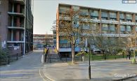
On Fann Street, just north of the Presbyterian Church of Wales. This area may once have been named Robin Hood Court / Google Earth Street View.
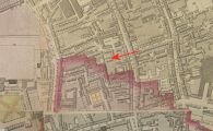
The area indicated by the red arrow was perhaps named Robin Hood Court in the early 19th century / Romantic London: Richard Horwood's map of London.