
Robin Hood Chase (Nottingham): Difference between revisions
m (Text replacement - "<!-- {{ImgGalleryIntro}} <gallery widths="195px"> FOR EACH IMAGE: File:_FILENAME.jpg|_LEGEND / [_URL _PHOTOGRAPHER, _DAY _MON. _YEAR, Creative Commons.] </gallery>-->" to "") |
m (Text replacement - "ImgGalleryIntro" to "ImageGalleryIntroduction") |
||
| (51 intermediate revisions by 2 users not shown) | |||
| Line 1: | Line 1: | ||
__NOTOC__{{ | __NOTOC__{{PlaceNamesItemTop|Lat=52.963043|Lon=-1.138849|AdministrativeDivision=Nottinghamshire|Vicinity=In Nottingham|Type=Thoroughfare|Interest=Robin Hood name|Status=Extant|Demonym=|Riding=|GreaterLondon=|Year=1881|Aka=Robin Hood's Chase; Robin Hoods Chase|Century=|Cluster1=Nottingham|Cluster2=Robin Hood Chase|Cluster3=|Image=Anonymous 19xxg-r.jpg|Postcards=Yes|ExtraCat1=|ExtraCat2=|ExtraCat3=|ExtraCat4=|ExtraCat5=|ExtraLink1=|ExtraLink2=|ExtraLink3=|ExtraLink4=|ExtraLink5=|ExtraLinkName1=|ExtraLinkName2=|ExtraLinkName3=|ExtraLinkName4=|ExtraLinkName5=|GeopointPrefix=|GeopointSuffix=|StatusSuffix=|DatePrefix=|DateSuffix=}} | ||
{{#display_map:{{#var:Coords}}|width=34%}}<div class="pnMapLegend">Robin Hood | {{#display_map:{{#var:Coords}}~{{#replace:{{PAGENAME}}|'|'}}|width=34%|enablefullscreen=yes}}<div class="pnMapLegend">Robin Hood Chase, a path in Nottingham.</div> | ||
[[File: | [[File:{{#var:Image}}|thumb|right|500px|{{:Anonymous 19xxg}} / HTN collection.]] | ||
[[File: | [[File:robin-hood-chase-nottingham.jpg|thumb|right|500px|Invitation to Poppie's birthday (see text) / Courtesy Stuart Timms.]]<div class="no-img"> | ||
<p id="byline">By Henrik Thiil Nielsen, 2016-05-24. Revised by {{#realname:{{REVISIONUSER}}}}, {{REVISIONYEAR}}-{{REVISIONMONTH}}-{{REVISIONDAY2}}.</p | <p id="byline">By Henrik Thiil Nielsen, 2016-05-24. Revised by {{#realname:{{REVISIONUSER}}}}, {{REVISIONYEAR}}-{{REVISIONMONTH}}-{{REVISIONDAY2}}; includes information and materials kindly provided by Stuart Timms.</p> | ||
Robin Hood's Chase is a path in | Robin Hood Chase, formerly known as 'Robin Hood's Chase', is a path, formerly a street, in Nottingham connecting Woodborough Road in the north-west and St Anne's Well Road in the south-east. The earliest record of the street name known to IRHB dates from 1883. | ||
=== Gazetteers | Until recently the earliest cartographical source on record at IRHB for this place-name was a 6" O.S. map of Nottingham published in 1885 and surveyed in 1880-81.<ref>[http://maps.nls.uk/view/101603268#zoom=6&lat=5762&lon=6927&layers=BT 6" O.S. map ''Nottinghamshire XLII.NW'' (incl. Nottingham; West Bridgford) (1885, surveyed 1880-81)]].</ref> Since last-minute revisions to maps are at least a theoretical possibility, IRHB always follows the practice of dating maps by their date of publication rather than that of the survey on which they are based. Stuart Timms has kindly supplied IRHB with printed evidence of Robin Hood Chase being in existence, being known as 'Robin Hood's Chase' and, as it were, being lived in a couple of years earlier.<ref>Email correspondence between Stuart Timms and Henrik Thiil Nielsen, 27 Aug. to 4 Sep. 2020.</ref> On a card printed in gold, Miss Ethel May, Stuart's great aunt 'Poppie', 'Requests the pleasure of Auntie Kate's Company on her Birthday, Tuesday, September 25th, 1883. Tea at Four o'clock. Carriages at eight. Regent Villas, Robin Hood's Chase'. The card is reproduced below. We can be sure that it was not Poppie herself who filled in the pre-printed card with the recipient's name, for the occasion was her second birthday. | ||
For a short while this was the earliest occurrence of the street name 'Robin Hood Chase' known to IRHB, but a slightly earlier map source was found when the 25" O.S. maps of the area were checked as part of the update of this page. It turns out that Robin Hood Chase is already included (and named) on a map published in 1881 and based on a survey carried out that year.<ref>[https://maps.nls.uk/view/115392374#zoom=5&lat=10003&lon=10096&layers=BT 25" O.S. map ''Nottinghamshire'' XLII.2 (1881; surveyed 1881).]</ref> Still, the invitation to Poppie's birthday remains the earliest non-cartographical evidence and it is of value also for what it tells us about the status of the street at the time. At least one prominent family lived there. Stuart Timms tells us that Poppie's grandfather, John Burton, was elected Mayor of Nottingham in 1884. Over time, it seems, the area became less fashionable, and recently it was felt that 'Robin Hood Chase off St Ann’s Well Road had seen a steady decline with under-occupied shops and maisonettes', so that the Nottingham City Council decided that redevelopment was required. This was completed by April of 2016.<ref>[https://www.mynottinghamnews.co.uk/transformation-of-robin-hood-chase-ends-with-a-new-space My Nottingham News: Transformation of Robin Hood Chase ends with a new space.]</ref> | |||
{{PlaceNamesItemAllusionsAndRecords}} | |||
== Gazetteers == | |||
* Not included in {{:Dobson, Richard Barrie 1976a}}, pp. 293-311. | * Not included in {{:Dobson, Richard Barrie 1976a}}, pp. 293-311. | ||
=== | == Maps == | ||
* [http://maps.nls.uk/view/101603268#zoom=6&lat=5762&lon=6927&layers=BT 6" O.S. map ''Nottinghamshire XLII.NW'' | * [https://maps.nls.uk/view/115392374#zoom=5&lat=10003&lon=10096&layers=BT 25" O.S. map ''Nottinghamshire'' XLII.2 (1881; surveyed 1881)] | ||
* [http://maps.nls.uk/view/101603265#zoom=5&lat=5782&lon=6934&layers=BT 6" O.S. map ''Nottinghamshire XLII.NW'' | * [https://maps.nls.uk/geo/explore/#zoom=17&lat=52.96427&lon=-1.14138&layers=168&b=5 25" O.S. map ''Nottinghamshire'' XLII.2 (1901; rev. 1899)] (georeferenced) | ||
* [http://maps.nls.uk/view/101603262#zoom=5&lat=5870&lon=6874&layers=BT 6" O.S. map ''Nottinghamshire XLII.NW'' | * [https://maps.nls.uk/view/115392377#zoom=5&lat=9920&lon=10422&layers=BT 25" O.S. map ''Nottinghamshire'' XLII.2 (1901; rev. 1899)] | ||
* [http://maps.nls.uk/view/101603259#zoom=5&lat=5927&lon=6412&layers=BT 6" O.S. map ''Nottinghamshire XLII.NW'' | * [https://maps.nls.uk/view/115392377#zoom=5&lat=9920&lon=10422&layers=BT 25" O.S. map ''Nottinghamshire'' XLII.2 (1901; rev. 1899)] | ||
* [https://maps.nls.uk/view/115392377#zoom=5&lat=9920&lon=10422&layers=BT 25" O.S. map ''Nottinghamshire'' XLII.2 (1915; rev. 1913)] | |||
* [http://maps.nls.uk/view/101603268#zoom=6&lat=5762&lon=6927&layers=BT 6" O.S. map ''Nottinghamshire XLII.NW'' (1885, surveyed 1880-81)] | |||
* [http://maps.nls.uk/view/101603265#zoom=5&lat=5782&lon=6934&layers=BT 6" O.S. map ''Nottinghamshire XLII.NW'' (1901, surveyed 1899)] | |||
* [http://maps.nls.uk/view/101603262#zoom=5&lat=5870&lon=6874&layers=BT 6" O.S. map ''Nottinghamshire XLII.NW'' (1920, rev. 1919)] | |||
* [http://maps.nls.uk/view/101603259#zoom=5&lat=5927&lon=6412&layers=BT 6" O.S. map ''Nottinghamshire XLII.NW'' (''c.''1947, surveyed 1938).] | |||
== Background == | |||
* [http://www.ng-spaces.org.uk/project-areas/public-walks The Social World of Nottingham's Green Spaces: Elm Avenue, Corporation Oaks and Robin Hood Chase] | |||
* [https://www.mynottinghamnews.co.uk/transformation-of-robin-hood-chase-ends-with-a-new-space My Nottingham News: Transformation of Robin Hood Chase ends with a new space] | |||
* [http://stannswellroad.weebly.com/robin-hood-chase.html St Ann's Well Road Pre-demolition (1970) (Facebook Online Community)]. Photos. | |||
{{PlaceNamesItemAlsoSee}} | |||
== Notes == | |||
<references/> | <references/> | ||
</div> | |||
<div id="gallery"> | |||
{{ImageGalleryIntroduction}} | |||
<gallery widths="195px"> | |||
Anonymous 19xxg-r.jpg|{{:Anonymous 19xxg}} / HTN collection. | |||
Anonymous 1907d-r.jpg|{{:Anonymous 1907d}} / HTN collection. | |||
robin-hood-chase-nottingham.jpg|Invitation to Poppie's birthday (see text) / Kindly supplied by Stuart Timms. | |||
</gallery> | |||
</div> | </div> | ||
{{ | {{PlaceNamesItemNavigation}} | ||
Latest revision as of 13:53, 7 January 2021
| Locality | |
|---|---|
| Coordinate | 52.963043, -1.138849 |
| Adm. div. | Nottinghamshire |
| Vicinity | In Nottingham |
| Type | Thoroughfare |
| Interest | Robin Hood name |
| Status | Extant |
| First Record | 1881 |
| A.k.a. | Robin Hood's Chase; Robin Hoods Chase |


By Henrik Thiil Nielsen, 2016-05-24. Revised by Henrik Thiil Nielsen, 2021-01-07; includes information and materials kindly provided by Stuart Timms.
Robin Hood Chase, formerly known as 'Robin Hood's Chase', is a path, formerly a street, in Nottingham connecting Woodborough Road in the north-west and St Anne's Well Road in the south-east. The earliest record of the street name known to IRHB dates from 1883.
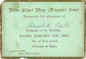
Until recently the earliest cartographical source on record at IRHB for this place-name was a 6" O.S. map of Nottingham published in 1885 and surveyed in 1880-81.[1] Since last-minute revisions to maps are at least a theoretical possibility, IRHB always follows the practice of dating maps by their date of publication rather than that of the survey on which they are based. Stuart Timms has kindly supplied IRHB with printed evidence of Robin Hood Chase being in existence, being known as 'Robin Hood's Chase' and, as it were, being lived in a couple of years earlier.[2] On a card printed in gold, Miss Ethel May, Stuart's great aunt 'Poppie', 'Requests the pleasure of Auntie Kate's Company on her Birthday, Tuesday, September 25th, 1883. Tea at Four o'clock. Carriages at eight. Regent Villas, Robin Hood's Chase'. The card is reproduced below. We can be sure that it was not Poppie herself who filled in the pre-printed card with the recipient's name, for the occasion was her second birthday.
For a short while this was the earliest occurrence of the street name 'Robin Hood Chase' known to IRHB, but a slightly earlier map source was found when the 25" O.S. maps of the area were checked as part of the update of this page. It turns out that Robin Hood Chase is already included (and named) on a map published in 1881 and based on a survey carried out that year.[3] Still, the invitation to Poppie's birthday remains the earliest non-cartographical evidence and it is of value also for what it tells us about the status of the street at the time. At least one prominent family lived there. Stuart Timms tells us that Poppie's grandfather, John Burton, was elected Mayor of Nottingham in 1884. Over time, it seems, the area became less fashionable, and recently it was felt that 'Robin Hood Chase off St Ann’s Well Road had seen a steady decline with under-occupied shops and maisonettes', so that the Nottingham City Council decided that redevelopment was required. This was completed by April of 2016.[4]
Gazetteers
- Not included in Dobson, R. B., ed.; Taylor, J., ed. Rymes of Robyn Hood: an Introduction to the English Outlaw (London, 1976), pp. 293-311.
Maps
- 25" O.S. map Nottinghamshire XLII.2 (1881; surveyed 1881)
- 25" O.S. map Nottinghamshire XLII.2 (1901; rev. 1899) (georeferenced)
- 25" O.S. map Nottinghamshire XLII.2 (1901; rev. 1899)
- 25" O.S. map Nottinghamshire XLII.2 (1901; rev. 1899)
- 25" O.S. map Nottinghamshire XLII.2 (1915; rev. 1913)
- 6" O.S. map Nottinghamshire XLII.NW (1885, surveyed 1880-81)
- 6" O.S. map Nottinghamshire XLII.NW (1901, surveyed 1899)
- 6" O.S. map Nottinghamshire XLII.NW (1920, rev. 1919)
- 6" O.S. map Nottinghamshire XLII.NW (c.1947, surveyed 1938).
Background
- The Social World of Nottingham's Green Spaces: Elm Avenue, Corporation Oaks and Robin Hood Chase
- My Nottingham News: Transformation of Robin Hood Chase ends with a new space
- St Ann's Well Road Pre-demolition (1970) (Facebook Online Community). Photos.
Also see
Notes
- ↑ 6" O.S. map Nottinghamshire XLII.NW (incl. Nottingham; West Bridgford) (1885, surveyed 1880-81)].
- ↑ Email correspondence between Stuart Timms and Henrik Thiil Nielsen, 27 Aug. to 4 Sep. 2020.
- ↑ 25" O.S. map Nottinghamshire XLII.2 (1881; surveyed 1881).
- ↑ My Nottingham News: Transformation of Robin Hood Chase ends with a new space.
Image gallery
Click any image to display it in the lightbox, where you can navigate between images by clicking in the right or left side of the current image.
Invitation to Poppie's birthday (see text) / Kindly supplied by Stuart Timms.
