
Robin Hood Butts (Clapham): Difference between revisions
mNo edit summary |
mNo edit summary |
||
| (2 intermediate revisions by the same user not shown) | |||
| Line 1: | Line 1: | ||
__NOTOC__{{PlaceNamesItemTop|Lat=54.114677|Lon=-2.450929|AdministrativeDivision=Yorkshire|Vicinity=''c.'' 3.6 km E of Bentham; ''c.'' 3.8 km W of Clapham|Type=Natural feature|Interest=Robin Hood name|Status=Extant|Demonym=|Riding=West|GreaterLondon=|Year=1738|Aka=Robin Hood But; Robin Hood's Butt; But Hill|Century=|Cluster1= | __NOTOC__{{PlaceNamesItemTop|Lat=54.114677|Lon=-2.450929|AdministrativeDivision=Yorkshire|Vicinity=''c.'' 3.6 km E of Bentham; ''c.'' 3.8 km W of Clapham|Type=Natural feature|Interest=Robin Hood name|Status=Extant|Demonym=|Riding=West|GreaterLondon=|Year=1738|Aka=Robin Hood But; Robin Hood's Butt; But Hill|Century=|Cluster1=Clapham|Cluster2=|Cluster3=|Image=geograph-3989134-by-Karl-and-Ali.jpg|Postcards=|ExtraCat1=Places named Robin Hood's Butts|ExtraCat2=|ExtraCat3=|ExtraCat4=|ExtraCat5=|GeopointPrefix=|GeopointSuffix=|StatusSuffix=|DatePrefix=|DateSuffix=}} | ||
{{#display_map:{{#var:Coords}}~{{#replace:{{PAGENAME}}|'|'}}|width=34%|enablefullscreen=yes}}<div class="pnMapLegend">Butt Hill or Robin Hood Butts, about midway between Bentham and Clapham in Craven.</div> | {{#display_map:{{#var:Coords}}~{{#replace:{{PAGENAME}}|'|'}}|width=34%|enablefullscreen=yes}}<div class="pnMapLegend">Butt Hill or Robin Hood Butts, about midway between Bentham and Clapham in Craven.</div> | ||
[[File:{{#var:Image}}|500px|thumb|right|Butt Hill in the foreground, Ingleborough in the background / [https://m.geograph.org.uk/photo/3989134 Karl and Ali, 22 May 2014, Creative Commons, via Geograph.]]] | [[File:{{#var:Image}}|500px|thumb|right|Butt Hill in the foreground, Ingleborough Hill in the background / [https://m.geograph.org.uk/photo/3989134 Karl and Ali, 22 May 2014, Creative Commons, via Geograph.]]] | ||
<div class="no-img"> | <div class="no-img"> | ||
<p id="byline">By Henrik Thiil Nielsen, 2014-09-05. Revised by {{#realname:{{REVISIONUSER}}}}, {{REVISIONYEAR}}-{{REVISIONMONTH}}-{{REVISIONDAY2}}.</p> | <p id="byline">By Henrik Thiil Nielsen, 2014-09-05. Revised by {{#realname:{{REVISIONUSER}}}}, {{REVISIONYEAR}}-{{REVISIONMONTH}}-{{REVISIONDAY2}}.</p> | ||
| Line 12: | Line 12: | ||
== Maps == | == Maps == | ||
* {{:Jefferys, Thomas 1772a}}, sheet 1, southwest tile | * {{:Jefferys, Thomas 1772a}}, sheet 1, southwest tile | ||
** [https://huddersfield.exposed/wiki/Jefferys%27_Map_of_Yorkshire_(1771)_-_sheet_1#customview=-378.6875:66.5625:4 web edition | ** [https://huddersfield.exposed/wiki/Jefferys%27_Map_of_Yorkshire_(1771)_-_sheet_1#customview=-378.6875:66.5625:4 web edition at Huddersfield Exposed, digitised by McMaster University] | ||
* [https://maps.nls.uk/view/125631832#zoom=4&lat=5697&lon=11091&layers=BT 25" O.S. map ''Yorkshire'' CXIII.9 (1894; surveyed 1893)] | * [https://maps.nls.uk/view/125631832#zoom=4&lat=5697&lon=11091&layers=BT 25" O.S. map ''Yorkshire'' CXIII.9 (1894; surveyed 1893)] | ||
* [https://maps.nls.uk/view/125631835#zoom=5&lat=5373&lon=11577&layers=BT 25" O.S. map ''Yorkshire'' CXIII.9 (1909; rev. 1907)] | * [https://maps.nls.uk/view/125631835#zoom=5&lat=5373&lon=11577&layers=BT 25" O.S. map ''Yorkshire'' CXIII.9 (1909; rev. 1907)] | ||
| Line 40: | Line 40: | ||
<gallery widths="195px"> | <gallery widths="195px"> | ||
robin_hood_butts_clapham_jefferys_thomas_1772a_sheet1_sw_tile.jpg|'Robin Hood But' near the top-right corner of this detail Jeffery's 1771-72 map of Yorkshire / [https://huddersfield.exposed/wiki/Jefferys%27_Map_of_Yorkshire_(1771)_-_sheet_1#customview=-384.0625:38.6875:4 Huddersfield Exposed: Jefferys' Map of Yorkshire (1771) - sheet 1; digitised by McMaster University; CC BY-NC 2.5 CA licence.] | robin_hood_butts_clapham_jefferys_thomas_1772a_sheet1_sw_tile.jpg|'Robin Hood But' near the top-right corner of this detail Jeffery's 1771-72 map of Yorkshire / [https://huddersfield.exposed/wiki/Jefferys%27_Map_of_Yorkshire_(1771)_-_sheet_1#customview=-384.0625:38.6875:4 Huddersfield Exposed: Jefferys' Map of Yorkshire (1771) - sheet 1; digitised by McMaster University; CC BY-NC 2.5 CA licence.] | ||
geograph-3989134-by-Karl-and-Ali.jpg|Butt Hill in the foreground, Ingleborough in the background / [https://m.geograph.org.uk/photo/3989134 Karl and Ali, 22 May 2014, Creative Commons, via Geograph.] | geograph-3989134-by-Karl-and-Ali.jpg|Butt Hill in the foreground, Ingleborough Hill in the background / [https://m.geograph.org.uk/photo/3989134 Karl and Ali, 22 May 2014, Creative Commons, via Geograph.] | ||
</gallery> | </gallery> | ||
{{PlaceNamesItemNavigation}} | {{PlaceNamesItemNavigation}} | ||
Latest revision as of 02:33, 30 May 2021
| Locality | |
|---|---|
| Coordinate | 54.114677, -2.450929 |
| Adm. div. | West Riding of Yorkshire |
| Vicinity | c. 3.6 km E of Bentham; c. 3.8 km W of Clapham |
| Type | Natural feature |
| Interest | Robin Hood name |
| Status | Extant |
| First Record | 1738 |
| A.k.a. | Robin Hood But; Robin Hood's Butt; But Hill |

By Henrik Thiil Nielsen, 2014-09-05. Revised by Henrik Thiil Nielsen, 2021-05-30.
But Hill, c. 3.6 km E of Bentham and c. 3.8 km W of Clapham, in Craven, also known as 'Robin Hood But', Robin Hood Butts or Robin Hoods's Butt, is probably a natural feature.
The name 'Robin Hood Butts' is first recorded with reference to this locality in the 1738 parish register of Thornton-in-Lonsdale.[1] 'Robin Hood But' is included on Jeffery's Map of Yorkshire, prepared 1771 and published the following year (see Maps section and image gallery below). The hill or mound is probably a natural feature but was tentatively included, under the name 'Robin Hood's Butt', in a list of mottes which was published in 1889. It is noted there that it 'is a mound, but its character is doubtful'.[2] Karl and Ali who took the photograph included below note that 'Butt Hill is a small, grassy hill with a scatter of mature trees which looks like it ought to have been a mediaeval motte earthwork. The map lettering does not suggest this, however[,] and it may simply be a natural feature such as a drumlin. Beyond, is Ingleborough (724m)'.[3] On the early O.S. maps listed below, the site is included as Butt Hill, never Robin Hood Butts or similar.
Formerly in the West Riding of Yorkshire, the area where the hill is situated now belongs administratively to North Yorkshire.
Maps
- Jefferys, Thomas, cartog. The County of York. Survey'd in MDCCLXVII., VIII., IX., and MDCCLXX (London, 1772), sheet 1, southwest tile
- 25" O.S. map Yorkshire CXIII.9 (1894; surveyed 1893)
- 25" O.S. map Yorkshire CXIII.9 (1909; rev. 1907)
- 25" O.S. map Bentham parish, Yorkshire (1950s) (georeferenced)
- 6" O.S. map Yorkshire 113 (1851; surveyed 1846–47)
- 6" O.S. map Yorkshire CXIII (1896; surveyed 1893)
- 6" O.S. map Yorkshire CXIII.SW (1910; rev. 1907) (georeferenced)
- 6" O.S. map Yorkshire CXIII.SW (1910; rev. 1907).
Gazetteers
- Not included in Dobson, R. B., ed.; Taylor, J., ed. Rymes of Robyn Hood: an Introduction to the English Outlaw (London, 1976), pp. 293-311.
Sources
- Chippindall, W. H., ed. The Parish Register of Thornton-in-Lonsdale, 1576-1812 (Yorkshire Parish Register Society, vol. 89) ([Leeds?], 1931). Not seen, but cf. A. H. Smith below
- Clark, George T., compil. 'Contribution towards a complete List of Moated Mounds or Burhs', The Archæological Journal, vol. XLVI (1889), pp. 197-217, see p. 207, where the mound is incorrectly included under Lancashire
- Heritage Gateway: Historic England Research Records: Butt Hill.
- Smith, A.H. The Place-Names of the West Riding of Yorkshire (English Place-Name Society, vols. XXX-XXXVII) (Cambridge, 1961-63), pt. VI, p. 241.
Background
Also see
Notes
- ↑ Chippindall, W. H., ed. The Parish Register of Thornton-in-Lonsdale, 1576-1812 (Yorkshire Parish Register Society, vol. 89) ([Leeds?], 1931). Not seen, but cf. Smith, A.H. The Place-Names of the West Riding of Yorkshire (English Place-Name Society, vols. XXX-XXXVII) (Cambridge, 1961-63), pt. VI, p. 241.
- ↑ Clark, George T., compil. 'Contribution towards a complete List of Moated Mounds or Burhs', The Archæological Journal, vol. XLVI (1889), pp. 197-217, see p. 207, where the mound is incorrectly included under Lancashire.
- ↑ Geograph: SD7068 :: Butt Hill and Ingleborough.
Image gallery
Click any image to display it in the lightbox, where you can navigate between images by clicking in the right or left side of the current image.
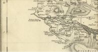
'Robin Hood But' near the top-right corner of this detail Jeffery's 1771-72 map of Yorkshire / Huddersfield Exposed: Jefferys' Map of Yorkshire (1771) - sheet 1; digitised by McMaster University; CC BY-NC 2.5 CA licence.
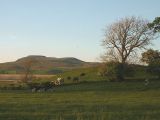
Butt Hill in the foreground, Ingleborough Hill in the background / Karl and Ali, 22 May 2014, Creative Commons, via Geograph.
