
Robin Hood Beck (Bassenthwaite): Difference between revisions
mNo edit summary |
m (Text replacement - "ImgGalleryIntro" to "ImageGalleryIntroduction") |
||
| (29 intermediate revisions by 2 users not shown) | |||
| Line 1: | Line 1: | ||
__NOTOC__{{ | __NOTOC__{{PlaceNamesItemTop|Lat=54.689448|Lon=-3.204713|AdministrativeDivision=Cumberland|Vicinity=''c.'' 150 m NNE of the Robin Hood Vicinity to an area north of the road Uldale ''c.'' 1.3 km NE of the Castle Inn on the B5291|Type=Natural feature|Interest=Robin Hood name|Status=Extant|Demonym=|Riding=|GreaterLondon=|Year=2005|Aka=|Century=|Cluster1=Bassenthwaite|Cluster2=|Cluster3=|Image=robin-hood-beck-bassenthwaite-2-google-earth-street-view.jpg|Postcards=|ExtraCat1=|ExtraCat2=|ExtraCat3=|ExtraCat4=|ExtraCat5=|ExtraLink1=|ExtraLink2=|ExtraLink3=|ExtraLink4=|ExtraLink5=|ExtraLinkName1=|ExtraLinkName2=|ExtraLinkName3=|ExtraLinkName4=|ExtraLinkName5=|GeopointPrefix=|GeopointSuffix=|StatusSuffix=|DatePrefix=|DateSuffix=}} | ||
{{#display_map:{{#var:Coords}}|width=34%}}<div class="pnMapLegend">Robin Hood Beck.</div> | {{#display_map:{{#var:Coords}}~{{#replace:{{PAGENAME}}|'|'}}|width=34%|enablefullscreen=yes}}<div class="pnMapLegend">Robin Hood Beck.</div> | ||
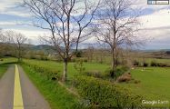
[[File:robin-hood-beck-bassenthwaite-2-google-earth-street-view.jpg|thumb|right|500px|Robin Hood Beck at Robin Hood Beck Bridge, south side of road / Google Earth Street View.]] | [[File:robin-hood-beck-bassenthwaite-2-google-earth-street-view.jpg|thumb|right|500px|Robin Hood Beck at Robin Hood Beck Bridge, south side of road / Google Earth Street View.]]<div class="no-img"> | ||
<p id="byline">By Henrik Thiil Nielsen, 2017-09-09. Revised by {{#realname:{{REVISIONUSER}}}}, {{REVISIONYEAR}}-{{REVISIONMONTH}}-{{REVISIONDAY2}}.</p> | <p id="byline">By Henrik Thiil Nielsen, 2017-09-09. Revised by {{#realname:{{REVISIONUSER}}}}, {{REVISIONYEAR}}-{{REVISIONMONTH}}-{{REVISIONDAY2}}.</p> | ||
Robin Hood Beck in Bassenthwaite has its origin ''c.'' 150 m NE of the [[Robin Hood (Bassenthwaite)]] vicinity or passes the latter there. It runs under the road to Uldale at [[Robin Hood Beck Bridge (Bassenthwaite)|Robin Hood Beck Bridge]], ''c.'' 1.3 km NE of Castle Inn on the B5291 and ''c.'' 600 m NNW of 'Robin Hood'. The only source I have found for this river name is the title of a 2005 photo by John Holmes on the Geograph site.<ref>[http://www.geograph.org.uk/photo/86913 Geograph: Robin Hood Beck Bridge.]</ref> He seems to know the area well,<ref>[http://www.geograph.org.uk/profile/3430 The majority of his large portfolio of Geograph photos are from Cumberland.]</ref> so most probably the name is in local use. | Robin Hood Beck in Bassenthwaite has its origin ''c.'' 150 m NE of the [[Robin Hood (Bassenthwaite)]] vicinity or passes the latter there. It runs under the road to Uldale at [[Robin Hood Beck Bridge (Bassenthwaite)|Robin Hood Beck Bridge]], ''c.'' 1.3 km NE of Castle Inn on the B5291 and ''c.'' 600 m NNW of 'Robin Hood'. The only source I have found for this river name is the title of a 2005 photo by John Holmes on the Geograph site.<ref>[http://www.geograph.org.uk/photo/86913 Geograph: Robin Hood Beck Bridge.]</ref> He seems to know the area well,<ref>[http://www.geograph.org.uk/profile/3430 The majority of his large portfolio of Geograph photos are from Cumberland.]</ref> so most probably the name is in local use. | ||
{{ | {{PlaceNamesItemAllusionsAndRecords}} | ||
== Gazetteers == | |||
* Not included in {{:Dobson, Richard Barrie 1976a}}, pp. 293-311. | * Not included in {{:Dobson, Richard Barrie 1976a}}, pp. 293-311. | ||
== Sources == | |||
* [http://www.geograph.org.uk/photo/86913 Geograph: Robin Hood Beck Bridge.] | * [http://www.geograph.org.uk/photo/86913 Geograph: Robin Hood Beck Bridge.] | ||
== Maps == | |||
* [http://maps.nls.uk/view/102340824#zoom=5&lat=2663&lon=14217&layers=BT 6" O.S. map ''Cumberland'' XLVI (1867; surveyed 1864-65)] | * [http://maps.nls.uk/view/102340824#zoom=5&lat=2663&lon=14217&layers=BT 6" O.S. map ''Cumberland'' XLVI (1867; surveyed 1864-65)] | ||
* [http://maps.nls.uk/view/101091685#zoom=4&lat=3221&lon=7291&layers=BT 6" O.S. map ''Cumberland'' XLVI.SE (1900; rev. 1898)] | * [http://maps.nls.uk/view/101091685#zoom=4&lat=3221&lon=7291&layers=BT 6" O.S. map ''Cumberland'' XLVI.SE (1900; rev. 1898)] | ||
* [http://maps.nls.uk/geo/explore/#zoom=15&lat=54.6895&lon=-3.2029&layers=171&b=1 6" O.S. map ''Cumberland'' XLVI.SE (1900; rev. 1898)] (georeferenced) | * [http://maps.nls.uk/geo/explore/#zoom=15&lat=54.6895&lon=-3.2029&layers=171&b=1 6" O.S. map ''Cumberland'' XLVI.SE (1900; rev. 1898)] (georeferenced) | ||
* [http://maps.nls.uk/view/101091682#zoom=4&lat=3513&lon=7589&layers=BT 6" O.S. map ''Cumberland'' XLVI.SE (1926; rev. 1923).] | * [http://maps.nls.uk/view/101091682#zoom=4&lat=3513&lon=7589&layers=BT 6" O.S. map ''Cumberland'' XLVI.SE (1926; rev. 1923).] | ||
== Background == | |||
* [https://en.wikipedia.org/wiki/Bassenthwaite Wikipedia: Bassenthwaite.] | * [https://en.wikipedia.org/wiki/Bassenthwaite Wikipedia: Bassenthwaite.] | ||
{{PlaceNamesItemAlsoSee}} | |||
== Notes == | |||
<references/> | <references/> | ||
</div> | |||
<div id="gallery"> | |||
< | {{ImageGalleryIntroduction}} | ||
{{ | |||
<gallery widths="195px"> | <gallery widths="195px"> | ||
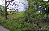
File:robin-hood-beck-bassenthwaite-3-google-earth-street-view.jpg|Upstream: Robin Hood Beck ''c.'' 150 m NE of 'Robin Hood' / Google Earth Street View. | File:robin-hood-beck-bassenthwaite-3-google-earth-street-view.jpg|Upstream: Robin Hood Beck ''c.'' 150 m NE of 'Robin Hood' / Google Earth Street View. | ||
| Line 32: | Line 28: | ||
File:Robin-hood-beck-bridge-bassenthwaite-google-earth-street-view.jpg|Downstream: Robin Hood Beck at Robin Hood Beck Bridge, north side of road / Google Earth Street View. | File:Robin-hood-beck-bridge-bassenthwaite-google-earth-street-view.jpg|Downstream: Robin Hood Beck at Robin Hood Beck Bridge, north side of road / Google Earth Street View. | ||
</gallery> | </gallery> | ||
</div> | |||
{{ | {{PlaceNamesItemNavigation}} | ||
Latest revision as of 13:53, 7 January 2021
| Locality | |
|---|---|
| Coordinate | 54.689448, -3.204713 |
| Adm. div. | Cumberland |
| Vicinity | c. 150 m NNE of the Robin Hood Vicinity to an area north of the road Uldale c. 1.3 km NE of the Castle Inn on the B5291 |
| Type | Natural feature |
| Interest | Robin Hood name |
| Status | Extant |
| First Record | 2005 |

By Henrik Thiil Nielsen, 2017-09-09. Revised by Henrik Thiil Nielsen, 2021-01-07.
Robin Hood Beck in Bassenthwaite has its origin c. 150 m NE of the Robin Hood (Bassenthwaite) vicinity or passes the latter there. It runs under the road to Uldale at Robin Hood Beck Bridge, c. 1.3 km NE of Castle Inn on the B5291 and c. 600 m NNW of 'Robin Hood'. The only source I have found for this river name is the title of a 2005 photo by John Holmes on the Geograph site.[1] He seems to know the area well,[2] so most probably the name is in local use.
Gazetteers
- Not included in Dobson, R. B., ed.; Taylor, J., ed. Rymes of Robyn Hood: an Introduction to the English Outlaw (London, 1976), pp. 293-311.
Sources
Maps
- 6" O.S. map Cumberland XLVI (1867; surveyed 1864-65)
- 6" O.S. map Cumberland XLVI.SE (1900; rev. 1898)
- 6" O.S. map Cumberland XLVI.SE (1900; rev. 1898) (georeferenced)
- 6" O.S. map Cumberland XLVI.SE (1926; rev. 1923).
Background
Also see
Notes
Image gallery
Click any image to display it in the lightbox, where you can navigate between images by clicking in the right or left side of the current image.
Upstream: Robin Hood Beck c. 150 m NE of 'Robin Hood' / Google Earth Street View.
Downstream: Robin Hood Beck at Robin Hood Beck Bridge, south side of road / Google Earth Street View.
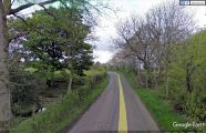
Downstream: Robin Hood Beck at Robin Hood Beck Bridge, north side of road / Google Earth Street View.

