
Robin Hood Bar (Baslow): Difference between revisions
(Created page with "__NOTOC__{{PlaceNamesItemTop|Lat=53.245670|Lon=-1.582096|AdministrativeDivision=Derbyshire|Vicinity=Chesterfield Road, Baslow|Type=Public house|Interest=Robin Hood name|Status...") |
m (Text replacement - ", piece" to ", Piece") |
||
| (17 intermediate revisions by the same user not shown) | |||
| Line 1: | Line 1: | ||
__NOTOC__{{PlaceNamesItemTop|Lat=53. | __NOTOC__{{PlaceNamesItemTop|Lat=53.2442|Lon=-1.5814|AdministrativeDivision=Derbyshire|Vicinity=South side of A619, hamlet of Robin Hood, Baslow|Type=Area|Interest=Robin Hood name|Status=Defunct|Demonym=|Riding=|GreaterLondon=|Year=1847|Aka=|Century=|Cluster1=Baslow|Cluster2=|Cluster3=|Image=geograph-2931067-by-Jonathan-Clitheroe.jpg|Postcards=|ExtraCat1=|ExtraCat2=|ExtraCat3=|ExtraCat4=|ExtraCat5=|ExtraLink1=|ExtraLink2=|ExtraLink3=|ExtraLink4=|ExtraLink5=|ExtraLinkName1=|ExtraLinkName2=|ExtraLinkName3=|ExtraLinkName4=|ExtraLinkName5=|GeopointPrefix=|GeopointSuffix=|StatusSuffix=?|DatePrefix=|DateSuffix=}} | ||
{{#display_map:{{#var:Coords}}~{{#replace:{{PAGENAME}}|'|'}}|controls=type,streetview|typestyle=dropdown|width=34%|enablefullscreen=yes}}<div class="pnMapLegend">The Robin Hood | {{#display_map:{{#var:Coords}}~{{#replace:{{PAGENAME}}|'|'}}|controls=type,streetview|typestyle=dropdown|width=34%|enablefullscreen=yes}}<div class="pnMapLegend">The area formerly (?) known as 'Robin Hood Bar'.</div> | ||
[[File: | [[File:{{#var:Image}}|thumb|right|500px|This area near Heathy Lea Brook was part of Robin Hood Bar: A well-marked footpath follows the contours of the brook which runs through a steep gorge ahead / [https://m.geograph.org.uk/photo/2931067 Jonathan Clitheroe, 5 May 2010; Creative Commons, via Geograph.]]]<div class="no-img"> | ||
<p id="byline">By Henrik Thiil Nielsen, | <p id="byline">By Henrik Thiil Nielsen, 2021-02-07. Revised by {{#realname:{{REVISIONUSER}}}}, {{REVISIONYEAR}}-{{REVISIONMONTH}}-{{REVISIONDAY2}}.</p> | ||
'Robin Hood Bar' was the name of a strip of land between the A619 and Heathy Lea Brook in the hamlet of Robin Hood, Baslow. | |||
In the 1847 tithe award for the 'Township of Baslow in the Parish of Bakewell' are listed five plots of land under the collective name of 'Robin Hood Bar', with the duke of Devonshire, i.e. William Cavendish, 6th Duke of Devonshire (1790–1858)<ref>[https://en.wikipedia.org/wiki/William_Cavendish,_6th_Duke_of_Devonshire Wikipedia: William Cavendish, 6th Duke of Devonshire.]</ref> as landowner and Thomas Savage as occupier: | |||
* plot <nowiki>#</nowiki>432: state of cultivation: 'Rough Pasture'; area: 1 acre 3 roods and 24 perches ({{AcresRoodsPerchesToM2|1|3|24}} m<sup>2</sup>) | * plot <nowiki>#</nowiki>432: state of cultivation: 'Rough Pasture'; area: 1 acre 3 roods and 24 perches ({{AcresRoodsPerchesToM2|1|3|24}} m<sup>2</sup>) | ||
* plot <nowiki>#</nowiki>433: state of cultivation: 'Rough Pasture'; area: 1 acre and 25 perches ({{AcresRoodsPerchesToM2|1|0|25}} m<sup>2</sup>) | * plot <nowiki>#</nowiki>433: state of cultivation: 'Rough Pasture'; area: 1 acre and 25 perches ({{AcresRoodsPerchesToM2|1|0|25}} m<sup>2</sup>) | ||
* plot <nowiki>#</nowiki>434: state of cultivation: 'Oats'; area: 1 acre 2 roods and 26 perches ({{AcresRoodsPerchesToM2|1|2|26}} m<sup>2</sup>) | * plot <nowiki>#</nowiki>434: state of cultivation: 'Oats'; area: 1 acre 2 roods and 26 perches ({{AcresRoodsPerchesToM2|1|2|26}} m<sup>2</sup>) | ||
* plot <nowiki>#</nowiki>436: state of cultivation: 'Meadow'; area: 1 acre 2 roods and 24 perches ({{AcresRoodsPerchesToM2|1|2|24}} m<sup>2</sup>) | * plot <nowiki>#</nowiki>436: state of cultivation: 'Meadow'; area: 1 acre 2 roods and 24 perches ({{AcresRoodsPerchesToM2|1|2|24}} m<sup>2</sup>) | ||
* plot <nowiki>#</nowiki>437: state of cultivation: 'Meadow'; area: 2 acre and 7 perches ({{AcresRoodsPerchesToM2|2|0|7}} m<sup>2</sup>).<ref>1847 tithe award for the 'Township of Baslow in the Parish of Bakewell', at the [https://www.thegenealogist.com Genealogist], | * plot <nowiki>#</nowiki>437: state of cultivation: 'Meadow'; area: 2 acre and 7 perches ({{AcresRoodsPerchesToM2|2|0|7}} m<sup>2</sup>).<ref>1847 tithe award for the 'Township of Baslow in the Parish of Bakewell', at the [https://www.thegenealogist.com Genealogist], Piece 08, sub-piece 020, Image 009, #432-34, 436-37 (£); accompanying map, online at the [https://www.thegenealogist.com Genealogist], Piece 08, sub-piece 020, Sub-Image 001, #432-34, 436-37 (£).</ref> | ||
All plots are contiguous, except that <nowiki>#</nowiki>434 and <nowiki>#</nowiki>436 are separated by <nowiki>#</nowiki>435, which figures in the tithe award as 'Engine Close' but would of course also have formed part of Robin Hood Bar (see map detail with the full area marked in shades of maroon and brown in the image gallery below). Also owned by the Duke of Devonshire, its occupier was a Benjamin Froggatt, state of cultivation 'Meadow' and the area 1 acre 1 rood and 1 perch ({{AcresRoodsPerchesToM2|1|1|1}} m<sup>2</sup>).<ref>1847 tithe award for the 'Township of Baslow in the Parish of Bakewell', at the [https://www.thegenealogist.com Genealogist], Piece 08, sub-piece 020, Image 008, #435 (£); accompanying map, online at the [https://www.thegenealogist.com Genealogist], Piece 08, sub-piece 020, Sub-Image 001, #435 (£).</ref> Including this plot, the total area of Robin Hood Bar would have been ''c.'' 39.128 m<sup>2</sup>. | |||
At its closest point, Robin Hood Bar is no more than ''c.'' 60 metres south of the [[Robin Hood Inn (Baslow)|Robin Hood Inn]]. The fact that this area does not include the plot north of the B6050 and the A619 on which the pub is situated, together with the states of cultivation of the plots, argues against the place-name element 'Bar' referring to the public house. It is of course conceivable that Thomas Savage, the occupier of these plots, was also the publican at the Robin Hood and that the strip of land acquired its name through this indirect connection with the public house. However, in our experience this would be unusual, just as one would not expect a country pub to be referred to as a 'Bar' at this time. Could 'Bar' here mean '[a] straight strip or stripe, narrow in proportion to its length, a broad line'?<ref>[https://www.oed.com/view/Entry/15349 ''OED'', bar, ''n. 1'', I, 5 a.]</ref> It certainly cannot be described as straight. A rather better explanation is that the element 'Bar' referred to the toll house of the Chesterfield & Hernstone Lane Head Turnpike Road,<ref>1847 tithe award for the 'Township of Baslow in the Parish of Bakewell', at the [https://www.thegenealogist.com Genealogist], Piece 08, sub-piece 020, Image 007, #365 (£); accompanying map, online at the [https://www.thegenealogist.com Genealogist], Piece 08, sub-piece 020, Sub-Image 001, #365 (£).</ref> which was located more or less on the grass area immediately west of B6050 as it leads north from the A619 to turn east and pass the pub. 'Bar' would thus mean 'toll-house gate or barrier'.<ref>[https://www.oed.com/view/Entry/15349 ''OED'', bar, ''n. 1'', II, 13 b.]</ref> Judging from the tithe map, the toll bar was situated just ten metres north of Robin Hood Bar. | |||
{{PlaceNamesItemAllusionsAndRecords}} | {{PlaceNamesItemAllusionsAndRecords}} | ||
== Gazetteers == | == Gazetteers == | ||
| Line 19: | Line 21: | ||
== MS sources == | == MS sources == | ||
* 1847 tithe award for the 'Township of Baslow in the Parish of Bakewell', at the [https://www.thegenealogist.com Genealogist], | * 1847 tithe award for the 'Township of Baslow in the Parish of Bakewell', at the [https://www.thegenealogist.com Genealogist], Piece 08, sub-piece 020, Image 009, #432-34, 436-37; and image 007, #365; image 008, #435 (£) | ||
* accompanying map, online at the [https://www.thegenealogist.com Genealogist], | * accompanying map, online at the [https://www.thegenealogist.com Genealogist], Piece 08, sub-piece 020, #432-37; and image 007, #365 (£). | ||
== Maps == | == Maps == | ||
* 25" O.S. map ''Derbyshire'' XXIV.2 (''c.'' 1879; surveyed ''c.'' 1878). No | * 25" O.S. map ''Derbyshire'' XXIV.2 (''c.'' 1879; surveyed ''c.'' 1878). No copy in NLS | ||
* [https://maps.nls.uk/view/114587717#zoom=4&lat=5125&lon=6147&layers=BT 25" O.S. map ''Derbyshire'' XXIV.2 (1898; rev. 1897)] | * [https://maps.nls.uk/view/114587717#zoom=4&lat=5125&lon=6147&layers=BT 25" O.S. map ''Derbyshire'' XXIV.2 (1898; rev. 1897)] | ||
* [https://maps.nls.uk/view/114587720#zoom=6&lat=5513&lon=6985&layers=BT 25" O.S. map ''Derbyshire'' XXIV.2 (1922; rev. 1919).] | * [https://maps.nls.uk/view/114587720#zoom=6&lat=5513&lon=6985&layers=BT 25" O.S. map ''Derbyshire'' XXIV.2 (1922; rev. 1919).] | ||
| Line 37: | Line 36: | ||
== Background == | == Background == | ||
* [https://www.oed.com/view/Entry/15349 ''OED'', bar, ''n. 1'', I, 5 a and II, 13 b] | |||
* [ | |||
* [https://en.wikipedia.org/wiki/William_Cavendish,_6th_Duke_of_Devonshire Wikipedia: William Cavendish, 6th Duke of Devonshire.] | * [https://en.wikipedia.org/wiki/William_Cavendish,_6th_Duke_of_Devonshire Wikipedia: William Cavendish, 6th Duke of Devonshire.] | ||
{{PlaceNamesItemAlsoSee}} | {{PlaceNamesItemAlsoSee}} | ||
| Line 47: | Line 44: | ||
</div> | </div> | ||
{{ImageGalleryIntroduction}} | |||
<gallery widths="195px"> | |||
geograph-2931067-by-Jonathan-Clitheroe.jpg|This area near Heathy Lea Brook was part of Robin Hood Bar: A well-marked footpath follows the contours of the brook which runs through a steep gorge ahead / [https://m.geograph.org.uk/photo/2931067 Jonathan Clitheroe, 5 May 2010; Creative Commons, via Geograph.] | |||
robin-hood-bar-baslow-google-earth-street-view-1.jpg|Looking roughly southwest from the A619 into Robin Hood Bar / Google Earth Street View. | |||
robin-hood-bar-baslow-google-earth-street-view-2.jpg|Looking roughly southwest from the A619 into Robin Hood Bar; further south / Google Earth Street View. | |||
robin-hood-bar-baslow-NLS.jpg|The five parts of Robin Hood Croft indicated in maroon and brown, plot numbers increasing from bottom to top; <nowiki>#</nowiki>434 not coloured / Detail of [http://maps.nls.uk/view/101600646#zoom=5&lat=4694&lon=6082&layers=BT 6" O.S. map ''Derbyshire'' XXIV.NW (1883; surveyed 1876–78);] reprod. with perm. of [https://maps.nls.uk NLS]; under [https://maps.nls.uk/copyright.html#exceptions Creative Commons Attrib. (CC-BY) license;] adapt. Henrik Thiil Nielsen. | |||
</gallery> | |||
{{PlaceNamesItemNavigation}} | {{PlaceNamesItemNavigation}} | ||
Latest revision as of 19:17, 22 April 2022
| Locality | |
|---|---|
| Coordinate | 53.2442, -1.5814 |
| Adm. div. | Derbyshire |
| Vicinity | South side of A619, hamlet of Robin Hood, Baslow |
| Type | Area |
| Interest | Robin Hood name |
| Status | Defunct? |
| First Record | 1847 |

By Henrik Thiil Nielsen, 2021-02-07. Revised by Henrik Thiil Nielsen, 2022-04-22.
'Robin Hood Bar' was the name of a strip of land between the A619 and Heathy Lea Brook in the hamlet of Robin Hood, Baslow.
In the 1847 tithe award for the 'Township of Baslow in the Parish of Bakewell' are listed five plots of land under the collective name of 'Robin Hood Bar', with the duke of Devonshire, i.e. William Cavendish, 6th Duke of Devonshire (1790–1858)[1] as landowner and Thomas Savage as occupier:
- plot #432: state of cultivation: 'Rough Pasture'; area: 1 acre 3 roods and 24 perches (7689.03 m2)
- plot #433: state of cultivation: 'Rough Pasture'; area: 1 acre and 25 perches (4679.18 m2)
- plot #434: state of cultivation: 'Oats'; area: 1 acre 2 roods and 26 perches (6727.9 m2)
- plot #436: state of cultivation: 'Meadow'; area: 1 acre 2 roods and 24 perches (6677.31 m2)
- plot #437: state of cultivation: 'Meadow'; area: 2 acre and 7 perches (8270.76 m2).[2]
All plots are contiguous, except that #434 and #436 are separated by #435, which figures in the tithe award as 'Engine Close' but would of course also have formed part of Robin Hood Bar (see map detail with the full area marked in shades of maroon and brown in the image gallery below). Also owned by the Duke of Devonshire, its occupier was a Benjamin Froggatt, state of cultivation 'Meadow' and the area 1 acre 1 rood and 1 perch (5083.86 m2).[3] Including this plot, the total area of Robin Hood Bar would have been c. 39.128 m2.
At its closest point, Robin Hood Bar is no more than c. 60 metres south of the Robin Hood Inn. The fact that this area does not include the plot north of the B6050 and the A619 on which the pub is situated, together with the states of cultivation of the plots, argues against the place-name element 'Bar' referring to the public house. It is of course conceivable that Thomas Savage, the occupier of these plots, was also the publican at the Robin Hood and that the strip of land acquired its name through this indirect connection with the public house. However, in our experience this would be unusual, just as one would not expect a country pub to be referred to as a 'Bar' at this time. Could 'Bar' here mean '[a] straight strip or stripe, narrow in proportion to its length, a broad line'?[4] It certainly cannot be described as straight. A rather better explanation is that the element 'Bar' referred to the toll house of the Chesterfield & Hernstone Lane Head Turnpike Road,[5] which was located more or less on the grass area immediately west of B6050 as it leads north from the A619 to turn east and pass the pub. 'Bar' would thus mean 'toll-house gate or barrier'.[6] Judging from the tithe map, the toll bar was situated just ten metres north of Robin Hood Bar.
Gazetteers
- Dobson, R. B., ed.; Taylor, J., ed. Rymes of Robyn Hood: an Introduction to the English Outlaw (London, 1976), pp. 296, s.n. "Robin Hood".
MS sources
- 1847 tithe award for the 'Township of Baslow in the Parish of Bakewell', at the Genealogist, Piece 08, sub-piece 020, Image 009, #432-34, 436-37; and image 007, #365; image 008, #435 (£)
- accompanying map, online at the Genealogist, Piece 08, sub-piece 020, #432-37; and image 007, #365 (£).
Maps
- 25" O.S. map Derbyshire XXIV.2 (c. 1879; surveyed c. 1878). No copy in NLS
- 25" O.S. map Derbyshire XXIV.2 (1898; rev. 1897)
- 25" O.S. map Derbyshire XXIV.2 (1922; rev. 1919).
- 25" O.S. map of Baslow And Bubnell parish, Derbyshire (1950s) (georeferenced)
- 6" O.S. map Derbyshire Sheet XXIV.NW (1883; surveyed 1876–78)
- 6" O.S. map Derbyshire XXIV.NW (1899; rev. 1897) (georeferenced)
- 6" O.S. map Derbyshire Sheet XXIV.NW (1899; rev. 1897)
- 6" O.S. map Derbyshire XXIV (1923; rev. 1919–20)
- 6" O.S. map Derbyshire Sheet XXIV.NW (1923; rev. 1919–20).
Background
Also see
Notes
- ↑ Wikipedia: William Cavendish, 6th Duke of Devonshire.
- ↑ 1847 tithe award for the 'Township of Baslow in the Parish of Bakewell', at the Genealogist, Piece 08, sub-piece 020, Image 009, #432-34, 436-37 (£); accompanying map, online at the Genealogist, Piece 08, sub-piece 020, Sub-Image 001, #432-34, 436-37 (£).
- ↑ 1847 tithe award for the 'Township of Baslow in the Parish of Bakewell', at the Genealogist, Piece 08, sub-piece 020, Image 008, #435 (£); accompanying map, online at the Genealogist, Piece 08, sub-piece 020, Sub-Image 001, #435 (£).
- ↑ OED, bar, n. 1, I, 5 a.
- ↑ 1847 tithe award for the 'Township of Baslow in the Parish of Bakewell', at the Genealogist, Piece 08, sub-piece 020, Image 007, #365 (£); accompanying map, online at the Genealogist, Piece 08, sub-piece 020, Sub-Image 001, #365 (£).
- ↑ OED, bar, n. 1, II, 13 b.
Image gallery
Click any image to display it in the lightbox, where you can navigate between images by clicking in the right or left side of the current image.
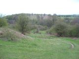
This area near Heathy Lea Brook was part of Robin Hood Bar: A well-marked footpath follows the contours of the brook which runs through a steep gorge ahead / Jonathan Clitheroe, 5 May 2010; Creative Commons, via Geograph.
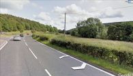
Looking roughly southwest from the A619 into Robin Hood Bar / Google Earth Street View.
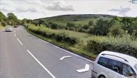
Looking roughly southwest from the A619 into Robin Hood Bar; further south / Google Earth Street View.
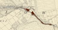
The five parts of Robin Hood Croft indicated in maroon and brown, plot numbers increasing from bottom to top; #434 not coloured / Detail of 6" O.S. map Derbyshire XXIV.NW (1883; surveyed 1876–78); reprod. with perm. of NLS; under Creative Commons Attrib. (CC-BY) license; adapt. Henrik Thiil Nielsen.


