|
|
| Line 1: |
Line 1: |
| __NOTOC__ | | __NOTOC__{{PnItemTop|Lat=51.105577|Lon=-0.835826|AdmDiv=Hampshire|Vicinity=Standford Lane, Standford, Bordon|Type=Public house|Interest=Robin Hood name|Status=Defunct|Demonym=|Riding=|GreaterLondon=|Year=|Aka=|Century=|Cluster1=|Cluster2=|Image=whiteley's_standford_lane_standford_bordon_hampshire.jpg|Postcards=|ExtraCat1=|ExtraCat2=|ExtraCat3=|ExtraCat4=|ExtraCat5=|GeopointPrefix=|GeopointSuffix=|VicinitySuffix=|StatusSuffix=|DatePrefix=|DateSuffix=?}} |
| {{Infobox
| | {{#display_map:{{#var:Coords}}|width=34%}}<div class="pnMapLegend">Approximate location of the Robin Hood, now Whiteleys Family Restaurant.</div> |
| |header1=Locality
| |
| |label2=Coordinates
| |
| |data2=[[Geopoint::51.105577,-0.835826]]
| |
| |label3=Adm. div.
| |
| |data3=[[pnadmdiv::Hampshire]]
| |
| |label4=Vicinity
| |
| |data4 = [[pnvicinity::Standford Lane, Standford, Bordon]]
| |
| |label5 = Type
| |
| |data5=[[pntype::Public house]]
| |
| |label6=Interest
| |
| |data6=[[pninterest::Robin Hood name]]
| |
| |label7=Status
| |
| |data7=[[pnstatus::Defunct]]
| |
| |label8=First Record
| |
| |data8=[[pnfirstrecord::]]?
| |
| }} | |
| {{#display_map:51.105577,-0.835826|width=34%}}<div class="pnMapLegend">Approximate location of the Robin Hood, now Whiteleys Family Restaurant.</div> | |
| [[File:whiteley's_standford_lane_standford_bordon_hampshire.jpg|500px|thumb|right|Now: whiteley's, Standford Lane (photo: proprietors via Google Earth.)]] | | [[File:whiteley's_standford_lane_standford_bordon_hampshire.jpg|500px|thumb|right|Now: whiteley's, Standford Lane (photo: proprietors via Google Earth.)]] |
| [[File:robin_hood_public_house_geograph.jpg|500px|thumb|right|The Robin Hood, Standford Lane (photo: [http://www.geograph.org.uk/profile/28338 Shazz] Nov. 25, 2008; Creative Commons Licence.)]] | | [[File:robin_hood_public_house_geograph.jpg|500px|thumb|right|The Robin Hood, Standford Lane (photo: [http://www.geograph.org.uk/profile/28338 Shazz] Nov. 25, 2008; Creative Commons Licence.)]] |
| Line 27: |
Line 10: |
|
| |
|
|
| |
|
| </div> | | </div><!-- |
| <div id="dplcatlinks" class="subcategory"><div id="dplcatarea"> | | {{ImgGalleryIntro}} |
| {{#ask: [[Category:English place-names]]
| | <gallery widths="195px"> |
| [[Category:Hampshire place-names]][[Utitle::<<{{#replace:{{uc:{{PAGENAME}}}}|'|'}}]]|order=descending|searchlabel=|format=template|introtemplate=BeforeNav|template=Nav|outrotemplate=Previous|link=none|limit=1|sort=Utitle}}[[Hampshire place-names]]{{#ask: [[Category:English place-names]]
| | FOR EACH IMAGE: File:_FILENAME.jpg|_LEGEND / [_URL _PHOTOGRAPHER, _DAY _MON. _YEAR, Creative Commons.] |
| [[Category:Hampshire place-names]][[Utitle::>>{{#replace:{{uc:{{PAGENAME}}}}|'|'}}]]|order=ascending|searchlabel=|format=template|introtemplate=BeforeNav|template=Nav|outrotemplate=Next|link=none|limit=1|sort=Utitle}}<br/>
| | </gallery>--> |
| {{#ask: [[Category:English place-names]][[Utitle::<<{{#replace:{{uc:{{PAGENAME}}}}|'|'}}]]|order=descending|searchlabel=|format=template|introtemplate=BeforeNav|template=Nav|outrotemplate=Previous|link=none|limit=1|sort=Utitle}}[[Place-names]]{{#ask: [[Category:English place-names]][[Utitle::>>{{#replace:{{uc:{{PAGENAME}}}}|'|'}}]]|order=ascending|searchlabel=|format=template|introtemplate=BeforeNav|template=Nav|outrotemplate=Next|link=none|limit=1|sort=Utitle}}</div></div>
| | |
| [[Category:English place-names]]
| | {{PnItemNav}} |
| [[Category:Hampshire place-names]]
| |
| [[Category:Place-names-topics]]
| |
| [[Category:unknown century]]
| |
| {{#set:century=?}}
| |
| {{#set:Utitle={{#replace:{{uc:{{PAGENAME}}}}|'|'}}}}
| |
| {{#set:Pnimage=whiteley's_standford_lane_standford_bordon_hampshire.jpg}}
| |
| {{#set:Pnimage=whiteley's_standford_lane_standford_bordon_hampshire.jpg}} | |
Template:PnItemTop
Loading map...
{"minzoom":false,"maxzoom":false,"mappingservice":"leaflet","width":"34%","height":"400px","centre":false,"title":"","label":"","icon":"","lines":[],"polygons":[],"circles":[],"rectangles":[],"copycoords":false,"static":false,"zoom":false,"defzoom":9,"layers":["OpenStreetMap","NLS","Stamen.Terrain"],"image layers":[],"overlays":[],"resizable":false,"fullscreen":false,"scrollwheelzoom":true,"cluster":false,"clustermaxzoom":20,"clusterzoomonclick":true,"clustermaxradius":80,"clusterspiderfy":true,"geojson":"","clicktarget":"","imageLayers":[],"locations":[],"imageoverlays":null}
Approximate location of the Robin Hood, now Whiteleys Family Restaurant.
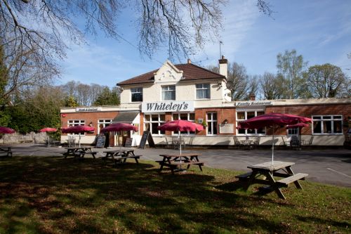
Now: whiteley's, Standford Lane (photo: proprietors via Google Earth.)
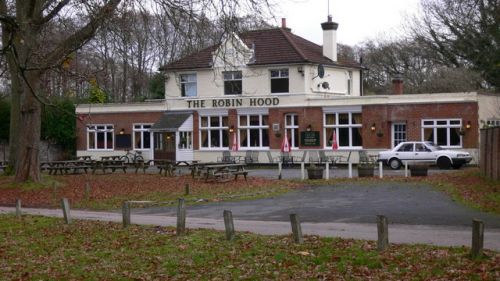
The Robin Hood, Standford Lane (photo:
Shazz Nov. 25, 2008; Creative Commons Licence.)
By Henrik Thiil Nielsen, 2013-07-28. Revised by Henrik Thiil Nielsen, 2017-12-04.
Now Whiteleys Family Restaurant, this was until recently the Robin Hood.
Gazetteers
Template:PnItemNav


