
Robin Hood (St James's Square)
From International Robin Hood Bibliography
| Locality | |
|---|---|
| Coordinate | 51.507648, -0.134071 |
| Adm. div. | Middlesex, now Greater London |
| Vicinity | On Charles II Street, NE of St James's Square, St James's, Westminster |
| Type | Public house |
| Interest | Robin Hood name |
| Status | Defunct |
| First Record | 1762 |
| A.k.a. | Robin-hood; Robin Hood and Little John |
Site of the Robin Hood, St James's Square


John Rocque's map of London and Westminster (1746), centred on the Robin Hood and Robin Hood's Yard / Locating London's Past.
By Henrik Thiil Nielsen, 2018-06-21. Revised by Henrik Thiil Nielsen, 2021-01-06.
A pub named the Robin Hood existed at one of London's most fashionable addresses, Charles II Street, often called simply Charles Street, by 1762 and at least until 1812. Presumably it lent its name to the adjacent Robin Hood Yard (St James's Square).
The pub, which figures occasionally in the records of the Old Bailey, was the venue for one or more meetings of the Freemasons of St. Andrew's Lodge in 1789.[1] Template:PlaceNamesItemQuery
Gazetteers
- Not included in Dobson, R. B., ed.; Taylor, J., ed. Rymes of Robyn Hood: an Introduction to the English Outlaw (London, 1976), pp. 293-311
Sources
Maps
- 25" O.S. map London (First Editions c1850s) XLIII (1878; surveyed 1869)
- 25" O.S. map London (Edition of 1894-96) LXXV (1897; rev. 1893-94)
- 25" O.S. map London (1915- Numbered sheets) V.13 (1916; rev. 1914)
- 25" O.S. map London (Edition of 1894-96) LXXV (1897; rev. 1893-94) (georeferenced).
- 6" O.S. map Middlesex XVII (1880-82; surveyed 1868-73)
- 6" O.S. map Surrey III (1880; surveyed 1868-73)
- 6" O.S. map London VII.SW (1894-96; rev. 1893-95)
- 6" O.S. map Surrey III.NW (1898; rev. 1893-95)
- 6" O.S. map London Sheet K (1920; rev. 1913-14)
- 6" O.S. map London Sheet K (c. 1946; rev. 1938)
- 6" O.S. map Surrey III.NW (1898; rev. 1893-95) (georeferenced).
Background
Also see
Notes
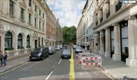
Robin Hood, St James's Square / Google Earth Street View.
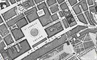
John Rocque's map of London and Westminster (1746), centred on the Robin Hood and Robin Hood's Yard / Locating London's Past.