
Robin Hood (Royston, Barnsley) (2): Difference between revisions
m (Text replacement - "<div class="no-img"><p id="byline">" to "<div class="no-img"> <p id="byline">") |
m (Text replacement - ", piece" to ", Piece") |
||
| (15 intermediate revisions by the same user not shown) | |||
| Line 1: | Line 1: | ||
__NOTOC__{{ | __NOTOC__{{PlaceNamesItemTop|Lat=53.602210|Lon=-1.443307|AdministrativeDivision=Yorkshire|Vicinity=Royston, Barnsley|Type=Area|Interest=Robin Hood name|Status=Defunct|Demonym=|Riding=West|GreaterLondon=|Year=1845|Aka=|Century=|Cluster1=Royston|Cluster2=|Cluster3=|Image=robin_hood_avenue_royston_looking_ne_google_earth.jpg|Postcards=|ExtraCat1=|ExtraCat2=|ExtraCat3=|ExtraCat4=|ExtraCat5=|ExtraLink1=Robinhoods Close (Brize Norton)|ExtraLink2=Robin Hood - Geranium robertianum|ExtraLink3=Robin Hood - Lychnis flos-cuculi|ExtraLink4=Robin Hood - Silene dioica|GeopointPrefix=|GeopointSuffix=|StatusSuffix=|DatePrefix=|DateSuffix=}} | ||
{{#display_map:{{#var:Coords}}~{{#replace:{{PAGENAME}}|'|'}}|width=34% | {{#display_map:{{#var:Coords}}~{{#replace:{{PAGENAME}}|'|'}}|width=34%|enablefullscreen=yes}}<div class="pnMapLegend">'Robin Hood' was (part of) the name or description of four plots of land in Royston.</div> | ||
[[File:robin_hood_avenue_royston_looking_ne_google_earth.jpg|thumb|right|500px|Looking north-east from Robin Hood Avenue / Google Earth Street View.]] | [[File:robin_hood_avenue_royston_looking_ne_google_earth.jpg|thumb|right|500px|Looking north-east from Robin Hood Avenue / Google Earth Street View.]] | ||
[[File:robin-hood-royston-2-NLS-map.jpg|thumb|right|500px|Detail of [https://maps.nls.uk/view/125647829#zoom=4&lat=6322&lon=12588&layers=BT 25" O.S. map ''Yorkshire'' CCLXII.12 (1893; surveyed 1891)] with the four 'Robin Hood' plots in gray / [https://maps.nls.uk/copyright.html#exceptions Reproduced with the permission of the National Library of Scotland.]]] | [[File:robin-hood-royston-2-NLS-map.jpg|thumb|right|500px|Detail of [https://maps.nls.uk/view/125647829#zoom=4&lat=6322&lon=12588&layers=BT 25" O.S. map ''Yorkshire'' CCLXII.12 (1893; surveyed 1891)] with the four 'Robin Hood' plots in gray / [https://maps.nls.uk/copyright.html#exceptions Reproduced with the permission of the National Library of Scotland.]]] | ||
| Line 9: | Line 9: | ||
The three connected plots, here treated as one area in view of their common name, and the adjacent fourth plot are best discussed together. The details provided for each in the tithe award, together with the corresponding field numbers in the earliest 25" O.S. maps (for which see below), are as follows: | The three connected plots, here treated as one area in view of their common name, and the adjacent fourth plot are best discussed together. The details provided for each in the tithe award, together with the corresponding field numbers in the earliest 25" O.S. maps (for which see below), are as follows: | ||
<p><ol><li>Plot No. 158. Name and Description of Lands and Premises: 'Humple & Robin Hood'. Owner/occupier: John Ball. State of Cultivation: Arable. Area: 6 acres, 2 roods and 1 perch ({{ | <p><ol><li>Plot No. 158. Name and Description of Lands and Premises: 'Humple & Robin Hood'. Owner/occupier: John Ball. State of Cultivation: Arable. Area: 6 acres, 2 roods and 1 perch ({{AcresRoodsPerchesToM2|6|2|1}} m<sup>2</sup>). No. 247 on early O.S. maps.</li> | ||
<li>Plot No. 162. Name and Description of Lands and Premises: 'Robin Hood'. Owner: Sir Theodore Broadhead. Occupier: John Bayldon. State of Cultivation: Arable. Area: 5 acres and 7 perches ({{ | <li>Plot No. 162. Name and Description of Lands and Premises: 'Robin Hood'. Owner: Sir Theodore Broadhead. Occupier: John Bayldon. State of Cultivation: Arable. Area: 5 acres and 7 perches ({{AcresRoodsPerchesToM2|5|0|7}} m<sup>2</sup>). No. 253 on early O.S. maps.</li> | ||
<li>Plot No. 166. Name and Description of Lands and Premises: 'Robin Hood'. Owner/occupier: John Bayldon, Esq. State of Cultivation: Arable. Area: 4 acres, 2 roods and 1 perch ({{ | <li>Plot No. 166. Name and Description of Lands and Premises: 'Robin Hood'. Owner/occupier: John Bayldon, Esq. State of Cultivation: Arable. Area: 4 acres, 2 roods and 1 perch ({{AcresRoodsPerchesToM2|4|2|1}} m<sup>2</sup>). No. 258 on early O.S. maps.</li> | ||
<li>Plot No. 167. Name and Description of Lands and Premises: 'Robin hood & Road'. Owner: Jonathan Ball. Occupier: William Woodcock. State of Cultivation: Arable and waste. Area: 5 acres and 11 perches ({{ | <li>Plot No. 167. Name and Description of Lands and Premises: 'Robin hood & Road'. Owner: Jonathan Ball. Occupier: William Woodcock. State of Cultivation: Arable and waste. Area: 5 acres and 11 perches ({{AcresRoodsPerchesToM2|5|0|11}} m<sup>2</sup>).<ref>Tithe award for Royston, online at the [https://www.thegenealogist.com Genealogist], Piece 43, sub-piece 340, Sub-Image 031, #162; sub-image 033, #166; sub-image 034, #158, #167 (£); accompanying map, online at the [https://www.thegenealogist.com Genealogist], Piece 43, sub-piece 340, Image 001, #158, #162, #166 -67 (£).</ref> Nos. 259-62, 268 on early O.S. maps.</li></ol></p> | ||
<p>Though the area has since become (sub)urbanized, not much had changed from the time the tithe map was drawn in 1845 to the earliest 25" O.S. map, which is based on surveying carried out in 1891. Its southern boundary is formed by the road named 'Senior Lane' on the tithe map and subsequently renamed Midland Road. The three connected plots stretch north from here to the footpath (which has since been) named Warren Walk. The fourth plot extends south from Common Lane, then named Low Common Lane, straddling the footpath. The easternmost of the three connected plots was shaped roughly like a mirror image capital 'L'. The present [[Robin Hood Avenue (Royston, Barnsley)|Robin Hood Avenue]], which more or less follows the centre line of the ascender of this <span class="mirror-image">L</span>, is presumably named after it. However, it is uncertain if 'Robin Hood' as used in the tithe award is in fact a field-name.</p> | <p>Though the area has since become (sub)urbanized, not much had changed from the time the tithe map was drawn in 1845 to the earliest 25" O.S. map, which is based on surveying carried out in 1891. Its southern boundary is formed by the road named 'Senior Lane' on the tithe map and subsequently renamed Midland Road. The three connected plots stretch north from here to the footpath (which has since been) named Warren Walk. The fourth plot extends south from Common Lane, then named Low Common Lane, straddling the footpath. The easternmost of the three connected plots was shaped roughly like a mirror image capital 'L'. The present [[Robin Hood Avenue (Royston, Barnsley)|Robin Hood Avenue]], which more or less follows the centre line of the ascender of this <span class="mirror-image">L</span>, is presumably named after it. However, it is uncertain if 'Robin Hood' as used in the tithe award is in fact a field-name.</p> | ||
In the first of the eight volumes on ''West Riding of Yorkshire Place-Names'' published by the English Place-Name Society, the editor A. H. Smith includes 'Robin Hood' in the list of Royston field-names. It is not clear to which of the four plots he referred, and in fact he showed no awareness that more than one plot was concerned.<ref>{{:Smith, Albert Hugh 1961a}}, pt. 1, p. 286.</ref> If 'Robin Hood' was a common name for much of the area covered by the four plots, one may wonder whether their respective owners/occupiers would not have felt a need to have separate names for them, and it is at least mildly surprising that a fifth plot, the one that separates the northwesternmost 'Robin Hood' from the other three, has an entirely different name, Rail Close.<ref>Tithe award for Royston, online at the [https://www.thegenealogist.com Genealogist], | In the first of the eight volumes on ''West Riding of Yorkshire Place-Names'' published by the English Place-Name Society, the editor A. H. Smith includes 'Robin Hood' in the list of Royston field-names. It is not clear to which of the four plots he referred, and in fact he showed no awareness that more than one plot was concerned.<ref>{{:Smith, Albert Hugh 1961a}}, pt. 1, p. 286.</ref> If 'Robin Hood' was a common name for much of the area covered by the four plots, one may wonder whether their respective owners/occupiers would not have felt a need to have separate names for them, and it is at least mildly surprising that a fifth plot, the one that separates the northwesternmost 'Robin Hood' from the other three, has an entirely different name, Rail Close.<ref>Tithe award for Royston, online at the [https://www.thegenealogist.com Genealogist], Piece 43, sub-piece 340, Sub-Image 038, #161 (£); accompanying map, online at the [https://www.thegenealogist.com Genealogist], Piece 43, sub-piece 340, Image 001, #161 (£).</ref> While it would be rash to insist on any of this, the combination 'Humple & Robin Hood' listed as 'Name and Description of Lands and Premises' for the northeastern plot does seem much more noteworthy. 'Little Humple' and 'Humple' ''tout court'' are similarly entered for two other plots.<ref>Tithe award for Royston, online at the [https://www.thegenealogist.com Genealogist], Piece 43, sub-piece 340, Sub-Image 045, #149-50 (£); accompanying map, online at the [https://www.thegenealogist.com Genealogist], Piece 43, sub-piece 340, Image 001, #161 (£).</ref> 'Hummel' or 'humble' can mean awnless, 'hummel' corn<ref>[https://oed.com/view/Entry/89385 ''OED'', ''s.v.'' hummel | humble, ''adj.'' (subscription required.)]</ref>, going back to 'himele', the ME name for the hop plant, also spelt 'humel(e)', 'humbel', 'hemel'.<ref>[https://quod.lib.umich.edu/m/middle-english-dictionary/dictionary/MED20805 himele ''n.'']</ref> In the column of the tithe awards labelled 'Name and Description of Lands and Premises' tithe commissioners tended to enter either a name or a description, more rarely both. Sometimes, it seems, people involved in the production of the English Place-Name Society's indispensable county survey volumes have treated the material entered there as though the heading read simply 'Name of Lands and Premises'. This may well have been the case here. At least three plants have the folk-name 'Robin Hood': [[Robin Hood - Geranium robertianum|''Geranium robertianum'']], [[Robin Hood - Lychnis flos-cuculi|''Lychnis flos-cuculi'']] and [[Robin Hood - Silene dioica|''Silene dioica'']]. Another editor for the English Place-Name Society, Margaret Gelling, suggested half a century ago that [[Robinhoods Close (Brize Norton)|Robinhoods Close at Brize Norton]] was named after one or other species of plant thus named. The collocation with 'Humple' suggests that this was also the case in Royston. Unless other evidence can be found for 'Robin Hood' as a Royston field name, it seems likely that 'Robin Hood', rather than being the name of the plots of land, served to characterize the four plots by reference to weeds that grew on them.{{PlaceNamesItemAllusionsAndRecords}} | ||
== Gazetteers == | == Gazetteers == | ||
* Not included in {{:Dobson, Richard Barrie 1976a}}, pp. 293-311. | * Not included in {{:Dobson, Richard Barrie 1976a}}, pp. 293-311. | ||
== MS sources == | == MS sources == | ||
* Tithe award for Royston, online at the [https://www.thegenealogist.com Genealogist], | * Tithe award for Royston, online at the [https://www.thegenealogist.com Genealogist], Piece 43, sub-piece 340, Sub-Image 031, #162; sub-image 033, #166; sub-image 034, #158, #167 (£) | ||
* accompanying map, online at the [https://www.thegenealogist.com Genealogist], | * accompanying map, online at the [https://www.thegenealogist.com Genealogist], Piece 43, sub-piece 340, Image 001, #158, #162, #166 #167 (£). | ||
== Printed sources == | == Printed sources == | ||
| Line 42: | Line 42: | ||
* [https://quod.lib.umich.edu/m/middle-english-dictionary/dictionary/MED20805 ''MED'', ''s.v,'' himele, ''n.''] | * [https://quod.lib.umich.edu/m/middle-english-dictionary/dictionary/MED20805 ''MED'', ''s.v,'' himele, ''n.''] | ||
* [https://oed.com/view/Entry/89385 ''OED'', ''s.v.'' hummel | humble, ''adj.'' (subscription required.)] | * [https://oed.com/view/Entry/89385 ''OED'', ''s.v.'' hummel | humble, ''adj.'' (subscription required.)] | ||
* Tithe award for Royston, online at the [https://www.thegenealogist.com Genealogist], | * Tithe award for Royston, online at the [https://www.thegenealogist.com Genealogist], Piece 43, sub-piece 340, Sub-Image 038, #161; sub-image 045, #149-50 (£) | ||
* accompanying map, online at the [https://www.thegenealogist.com Genealogist], | * accompanying map, online at the [https://www.thegenealogist.com Genealogist], Piece 43, sub-piece 340, Image 001, #161, #149-50 (£). | ||
{{ | {{PlaceNamesItemAlsoSee}} | ||
== Notes == | == Notes == | ||
| Line 53: | Line 53: | ||
<div id="gallery"> | <div id="gallery"> | ||
{{ | {{ImageGalleryIntroduction}} | ||
<gallery widths="195px"> | <gallery widths="195px"> | ||
robin_hood_avenue_royston_looking_ne_google_earth.jpg|Looking north-east from Robin Hood Avenue / Google Earth Street View. | robin_hood_avenue_royston_looking_ne_google_earth.jpg|Looking north-east from Robin Hood Avenue / Google Earth Street View. | ||
| Line 60: | Line 60: | ||
</div> | </div> | ||
{{ | {{PlaceNamesItemNavigation}} | ||
Latest revision as of 19:15, 22 April 2022
| Locality | |
|---|---|
| Coordinate | 53.60221, -1.443307 |
| Adm. div. | West Riding of Yorkshire |
| Vicinity | Royston, Barnsley |
| Type | Area |
| Interest | Robin Hood name |
| Status | Defunct |
| First Record | 1845 |


By Henrik Thiil Nielsen, 2016-15-11. Revised by Henrik Thiil Nielsen, 2022-04-22.
Robin Hood occurs as a field name or characterization of no less than four plots of land in the 1845 MS tithe award for Royston, which is now a suburban village within the Metropolitan borough of Barnsley. Three of the plots form one continuous area, while the fourth, entered separately at IRHB as Robin Hood (Royston, Barnsley) (1), is situated slightly north-west of them, the distance between it and the nearest 'Robin Hood' plot being no more than c. 35 m.
The three connected plots, here treated as one area in view of their common name, and the adjacent fourth plot are best discussed together. The details provided for each in the tithe award, together with the corresponding field numbers in the earliest 25" O.S. maps (for which see below), are as follows:
- Plot No. 158. Name and Description of Lands and Premises: 'Humple & Robin Hood'. Owner/occupier: John Ball. State of Cultivation: Arable. Area: 6 acres, 2 roods and 1 perch (26329.86 m2). No. 247 on early O.S. maps.
- Plot No. 162. Name and Description of Lands and Premises: 'Robin Hood'. Owner: Sir Theodore Broadhead. Occupier: John Bayldon. State of Cultivation: Arable. Area: 5 acres and 7 perches (20411.33 m2). No. 253 on early O.S. maps.
- Plot No. 166. Name and Description of Lands and Premises: 'Robin Hood'. Owner/occupier: John Bayldon, Esq. State of Cultivation: Arable. Area: 4 acres, 2 roods and 1 perch (18236.15 m2). No. 258 on early O.S. maps.
- Plot No. 167. Name and Description of Lands and Premises: 'Robin hood & Road'. Owner: Jonathan Ball. Occupier: William Woodcock. State of Cultivation: Arable and waste. Area: 5 acres and 11 perches (20512.5 m2).[1] Nos. 259-62, 268 on early O.S. maps.
Though the area has since become (sub)urbanized, not much had changed from the time the tithe map was drawn in 1845 to the earliest 25" O.S. map, which is based on surveying carried out in 1891. Its southern boundary is formed by the road named 'Senior Lane' on the tithe map and subsequently renamed Midland Road. The three connected plots stretch north from here to the footpath (which has since been) named Warren Walk. The fourth plot extends south from Common Lane, then named Low Common Lane, straddling the footpath. The easternmost of the three connected plots was shaped roughly like a mirror image capital 'L'. The present Robin Hood Avenue, which more or less follows the centre line of the ascender of this L, is presumably named after it. However, it is uncertain if 'Robin Hood' as used in the tithe award is in fact a field-name.
In the first of the eight volumes on West Riding of Yorkshire Place-Names published by the English Place-Name Society, the editor A. H. Smith includes 'Robin Hood' in the list of Royston field-names. It is not clear to which of the four plots he referred, and in fact he showed no awareness that more than one plot was concerned.[2] If 'Robin Hood' was a common name for much of the area covered by the four plots, one may wonder whether their respective owners/occupiers would not have felt a need to have separate names for them, and it is at least mildly surprising that a fifth plot, the one that separates the northwesternmost 'Robin Hood' from the other three, has an entirely different name, Rail Close.[3] While it would be rash to insist on any of this, the combination 'Humple & Robin Hood' listed as 'Name and Description of Lands and Premises' for the northeastern plot does seem much more noteworthy. 'Little Humple' and 'Humple' tout court are similarly entered for two other plots.[4] 'Hummel' or 'humble' can mean awnless, 'hummel' corn[5], going back to 'himele', the ME name for the hop plant, also spelt 'humel(e)', 'humbel', 'hemel'.[6] In the column of the tithe awards labelled 'Name and Description of Lands and Premises' tithe commissioners tended to enter either a name or a description, more rarely both. Sometimes, it seems, people involved in the production of the English Place-Name Society's indispensable county survey volumes have treated the material entered there as though the heading read simply 'Name of Lands and Premises'. This may well have been the case here. At least three plants have the folk-name 'Robin Hood': Geranium robertianum, Lychnis flos-cuculi and Silene dioica. Another editor for the English Place-Name Society, Margaret Gelling, suggested half a century ago that Robinhoods Close at Brize Norton was named after one or other species of plant thus named. The collocation with 'Humple' suggests that this was also the case in Royston. Unless other evidence can be found for 'Robin Hood' as a Royston field name, it seems likely that 'Robin Hood', rather than being the name of the plots of land, served to characterize the four plots by reference to weeds that grew on them.
Gazetteers
- Not included in Dobson, R. B., ed.; Taylor, J., ed. Rymes of Robyn Hood: an Introduction to the English Outlaw (London, 1976), pp. 293-311.
MS sources
- Tithe award for Royston, online at the Genealogist, Piece 43, sub-piece 340, Sub-Image 031, #162; sub-image 033, #166; sub-image 034, #158, #167 (£)
- accompanying map, online at the Genealogist, Piece 43, sub-piece 340, Image 001, #158, #162, #166 #167 (£).
Printed sources
- Smith, A.H. The Place-Names of the West Riding of Yorkshire (English Place-Name Society, vols. XXX-XXXVII) (Cambridge, 1961-63), pt. 1, p. 286, refers to this or Robin Hood (Royston, Barnsley) (1).
Maps
- 25" O.S. map Yorkshire CCLXII.12 (1893; surveyed 1891)
- 25" O.S. map Yorkshire CCLXII.12 (1906, rev. 1904) (georeferenced)
- 25" O.S. map Yorkshire CCLXII.12 (1906; rev. 1904)
- 25" O.S. map Yorkshire CCLXII.12 (1918; rev. 1914)
- 25" O.S. map Yorkshire CCLXII.12 (1918; rev. 1914)
- 6" O.S. map Yorkshire CCLXII.SE (1894; surveyed 1891)
- 6" O.S. map Yorkshire CCLXII.SE (1907; rev. 1904)
- 6" O.S. map Yorkshire CCLXII.SE (1907; rev. 1904) (georeferenced)
- 6" O.S. map Yorkshire CCLXII.SE (1932; rev. 1929-30)
- 6" O.S. map Yorkshire CCLXII.SE (1947; rev. 1938)
- 6" O.S. map Yorkshire CCLXII.SE (1949; rev. 1948).
Background
- MED, s.v, himele, n.
- OED, s.v. hummel | humble, adj. (subscription required.)
- Tithe award for Royston, online at the Genealogist, Piece 43, sub-piece 340, Sub-Image 038, #161; sub-image 045, #149-50 (£)
- accompanying map, online at the Genealogist, Piece 43, sub-piece 340, Image 001, #161, #149-50 (£).
Also see
- Royston place-name cluster
- Robinhoods Close (Brize Norton)
- Robin Hood - Geranium robertianum
- Robin Hood - Lychnis flos-cuculi
- Robin Hood - Silene dioica.
Notes
- ↑ Tithe award for Royston, online at the Genealogist, Piece 43, sub-piece 340, Sub-Image 031, #162; sub-image 033, #166; sub-image 034, #158, #167 (£); accompanying map, online at the Genealogist, Piece 43, sub-piece 340, Image 001, #158, #162, #166 -67 (£).
- ↑ Smith, A.H. The Place-Names of the West Riding of Yorkshire (English Place-Name Society, vols. XXX-XXXVII) (Cambridge, 1961-63), pt. 1, p. 286.
- ↑ Tithe award for Royston, online at the Genealogist, Piece 43, sub-piece 340, Sub-Image 038, #161 (£); accompanying map, online at the Genealogist, Piece 43, sub-piece 340, Image 001, #161 (£).
- ↑ Tithe award for Royston, online at the Genealogist, Piece 43, sub-piece 340, Sub-Image 045, #149-50 (£); accompanying map, online at the Genealogist, Piece 43, sub-piece 340, Image 001, #161 (£).
- ↑ OED, s.v. hummel | humble, adj. (subscription required.)
- ↑ himele n.
Image gallery
Click any image to display it in the lightbox, where you can navigate between images by clicking in the right or left side of the current image.
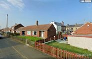
Looking north-east from Robin Hood Avenue / Google Earth Street View.
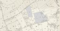
Detail of 25" O.S. map Yorkshire CCLXII.12 (1893; surveyed 1891) with the four 'Robin Hood' plots in gray / Reproduced with the permission of the National Library of Scotland.