
Robin Hood (Kirkby in Ashfield): Difference between revisions
m (Text replacement - "Creative Commons via Geograph" to "Creative Commons, via Geograph") |
m (→Maps) |
||
| Line 15: | Line 15: | ||
== Maps == | == Maps == | ||
* [https://maps.nls.uk/view/115391297#zoom=4&lat=9528&lon=12661&layers=BT 25" O.S. map ''Nottinghamshire'' XXXII.3 (1878; surveyed 1877)] | * [https://maps.nls.uk/view/115391297#zoom=4&lat=9528&lon=12661&layers=BT 25" O.S. map ''Nottinghamshire'' XXXII.3 (1878; surveyed 1877)] | ||
* [https://maps.nls.uk/view/115391300#zoom=4&lat=9632&lon=12407&layers=BT 25" O.S. map ''Nottinghamshire'' XXXII.3 (1900; rev. 1898-99)] | * [https://maps.nls.uk/view/115391300#zoom=4&lat=9632&lon=12407&layers=BT 25" O.S. map ''Nottinghamshire'' XXXII.3 (1900; rev. 1898-99)] | ||
| Line 26: | Line 21: | ||
* [https://maps.nls.uk/view/115391306#zoom=5&lat=10152&lon=12348&layers=BT 25" O.S. map ''Nottinghamshire'' XXXII.3 (1947; rev. 1938-39)] | * [https://maps.nls.uk/view/115391306#zoom=5&lat=10152&lon=12348&layers=BT 25" O.S. map ''Nottinghamshire'' XXXII.3 (1947; rev. 1938-39)] | ||
* [https://maps.nls.uk/view/102341379#zoom=5&lat=10606&lon=10721&layers=BT 6" O.S. map ''Derbyshire'' XLI (1921; rev. 1913-14)] | * [https://maps.nls.uk/view/102341379#zoom=5&lat=10606&lon=10721&layers=BT 6" O.S. map ''Derbyshire'' XLI (1921; rev. 1913-14)] | ||
* [https://maps.nls.uk/view/101602911#zoom=5&lat=5901&lon=4357&layers=BT 6" O.S. map ''Nottinghamshire'' XXXII.NE (1886; surveyed 1878-79)] | |||
* [http://maps.nls.uk/geo/explore/#zoom=16&lat=53.0793&lon=-1.2431&layers=6&b=5 6" O.S. map ''Nottinghamshire'' XXIII.NE (1900; rev. 1898-99)] (georeferenced) | * [http://maps.nls.uk/geo/explore/#zoom=16&lat=53.0793&lon=-1.2431&layers=6&b=5 6" O.S. map ''Nottinghamshire'' XXIII.NE (1900; rev. 1898-99)] (georeferenced) | ||
* [https://maps.nls.uk/view/101602908#zoom=4&lat=5835&lon=4125&layers=BT 6" O.S. map ''Nottinghamshire'' XXXII.NE (1900; rev. 1898-99)] | |||
* [https://maps.nls.uk/view/101602905#zoom=4&lat=5761&lon=4166&layers=BT 6" O.S. map ''Nottinghamshire'' XXXII.NE (1920; rev. 1914)] | |||
* [https://maps.nls.uk/view/101602902#zoom=4&lat=5781&lon=4342&layers=BT 6" O.S. map ''Nottinghamshire'' XXXII.NE (1921; rev. 1914)] | |||
* [https://maps.nls.uk/view/101602899#zoom=4&lat=5874&lon=4454&layers=BT 6" O.S. map ''Nottinghamshire'' XXXII.NE (''c.'' 1948; rev. 1938).] | |||
{{PnItemAlsoSee}} | {{PnItemAlsoSee}} | ||
== Notes == | == Notes == | ||
<references/> | <references/> | ||
Revision as of 08:53, 1 June 2019

By Henrik Thiil Nielsen, 2016-10-04. Revised by Henrik Thiil Nielsen, 2019-06-01.
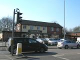
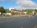
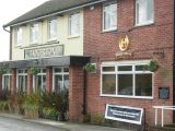
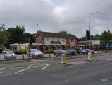
The Robin Hood, a public house, was located on the corner of Derby Road and Forest Road in Annesley, not quite 3 km SE of central Kirkby in Ashfield. 675 m NNE of the public house was found Robin Hood's Cave (Kirkby in Ashfield), while Robin Hood's Hills and Robin Hood's Chair are found c. 1.2 km NNE of the Robin Hood. The Robin Hood is indicated on O.S. maps of the area published 1878–c. 1948 (see Maps section below). There is a recently built pub/restaurant named the Badger Box on Derby Road, but this is ten metres or so north of the site of the Robin Hood, unless the course of Forest Road was changed a little.
Information on publicans for the years 1925-41 can be found at UK Pub History.[1] Template:PnItemQry
Gazetteers
- Not included in Dobson, R. B., ed.; Taylor, J., ed. Rymes of Robyn Hood: an Introduction to the English Outlaw (London, 1976), pp. 293-311.
Sources
Maps
- 25" O.S. map Nottinghamshire XXXII.3 (1878; surveyed 1877)
- 25" O.S. map Nottinghamshire XXXII.3 (1900; rev. 1898-99)
- 25" O.S. map Nottinghamshire XXXII.3 (1900; rev. 1898-99) (georeferenced)
- 25" O.S. map Nottinghamshire XXXII.3 (1915; rev. 1914)
- 25" O.S. map Nottinghamshire XXXII.3 (1947; rev. 1938-39)
- 6" O.S. map Derbyshire XLI (1921; rev. 1913-14)
- 6" O.S. map Nottinghamshire XXXII.NE (1886; surveyed 1878-79)
- 6" O.S. map Nottinghamshire XXIII.NE (1900; rev. 1898-99) (georeferenced)
- 6" O.S. map Nottinghamshire XXXII.NE (1900; rev. 1898-99)
- 6" O.S. map Nottinghamshire XXXII.NE (1920; rev. 1914)
- 6" O.S. map Nottinghamshire XXXII.NE (1921; rev. 1914)
- 6" O.S. map Nottinghamshire XXXII.NE (c. 1948; rev. 1938).
Notes
- ↑ UK Pub History: Robin Hood, East Kirkby, Annesley Woodhouse, Nottinghamshire. "East Kirkby" is a mistake, There is one in Lincolnshire, but none near Annesley.
- ↑ As previously noted, "East Kirkby" is a mistake,
The Badger Box, Annesley / J. Thomas, 16 Apr. 2010, Creative Commons, via Geograph.
The Badger Box; Greene King (Hungry Horse) pub on the busy Derby Road, with lots of parking space. A garage and general store next door. / Trevor Rickard, 16 OCt. 2010, Creative Commons, via Geograph.
The Badger Box, Annesley
Badger Box Public House, Annesley, on the A611 between Hucknall and Mansfield / Phil Evans, 24 Jul. 2008, Creative Commons, via Geograph.
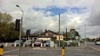
The Badger Box, Annesley, a Hungry Horse pub / Chris Morgan, 3 may 2016, Creative Commons, via Geograph.


