
Robin Hood (Kirkby in Ashfield): Difference between revisions
mNo edit summary |
m (Text replacement - "UK Pub History" to "Pub History") |
||
| (22 intermediate revisions by 2 users not shown) | |||
| Line 1: | Line 1: | ||
__NOTOC__{{ | __NOTOC__{{PlaceNamesItemTop|Lat=53.0790|Lon=-1.2428|AdministrativeDivision=Nottinghamshire|Vicinity=2.9 km SE of central Kirkby in Ashfield|Type=Public house|Interest=Robin Hood name|Status=Defunct|Demonym=|Riding=|GreaterLondon=|Year=1878|Aka=Badger Box|Century=|Cluster1=Kirkby in Ashfield|Cluster2=|Cluster3=|Image=site_of_robin_hood_kirkby_in_ashfield.jpg|Postcards=|ExtraCat1=|ExtraCat2=|ExtraCat3=|ExtraCat4=|ExtraCat5=|ExtraLink1=|ExtraLink2=|ExtraLink3=|ExtraLink4=|ExtraLink5=|ExtraLinkName1=|ExtraLinkName2=|ExtraLinkName3=|ExtraLinkName4=|ExtraLinkName5=|GeopointPrefix=|GeopointSuffix=|StatusSuffix=|DatePrefix=|DateSuffix=}} | ||
{{#display_map:{{#var:Coords}}~{{#replace:{{PAGENAME}}|'|'}}|width=34%}}<div class="pnMapLegend">Site of the Robin Hood.</div> | {{#display_map:{{#var:Coords}}~{{#replace:{{PAGENAME}}|'|'}}|width=34%|enablefullscreen=yes}}<div class="pnMapLegend">Site of the Robin Hood.</div> | ||
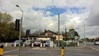
[[File:site_of_robin_hood_kirkby_in_ashfield.jpg|thumb|right|500px|From 1878 | [[File:site_of_robin_hood_kirkby_in_ashfield.jpg|thumb|right|500px|From 1878 or earlier to 1941 or later, the Robin Hood was located on the corner of Forest Road and Derby Road in Annesley Woodhouse, Kirkby in Ashfield / Google Earth Street View.]]<div class="no-img"> | ||
<p id="byline">By Henrik Thiil Nielsen, 2016-10-04. Revised by {{#realname:{{REVISIONUSER}}}}, {{REVISIONYEAR}}-{{REVISIONMONTH}}-{{REVISIONDAY2}}.</p> | <p id="byline">By Henrik Thiil Nielsen, 2016-10-04. Revised by {{#realname:{{REVISIONUSER}}}}, {{REVISIONYEAR}}-{{REVISIONMONTH}}-{{REVISIONDAY2}}.</p> | ||
The [[Robin Hood]], a public house, was located on the corner of Derby Road and Forest Road in Annesley, not quite 3 km SE of central Kirkby in Ashfield. 675 m NNE of the public house was found [[Robin Hood's Cave (Kirkby in Ashfield)]], while [[Robin Hood's Hills (Kirkby in Ashfield)|Robin Hood's Hills]] and [[Robin Hood's Chair (Kirkby in Ashfield)|Robin Hood's Chair]] are found ''c.'' 1.2 km NNE of the Robin Hood. The Robin Hood is indicated on O.S. maps of the area published 1878–''c.'' 1948 (see Maps section below). There is a recently built pub/restaurant named the Badger Box on Derby Road, but this is ten metres or so north of the site of the Robin Hood, unless the course of Forest Road was changed a little. | |||
The [[Robin Hood]], a public house, was located on the corner of Derby Road and Forest Road in Annesley, not quite 3 km SE of central Kirkby in Ashfield. 675 m NNE of the public house was found [[Robin Hood's Cave (Kirkby in Ashfield)]], while [[Robin Hood's Hills (Kirkby in Ashfield)|Robin Hood's Hills]] and [[Robin Hood's Chair (Kirkby in Ashfield)|Robin Hood's Chair]] are found ''c.'' 1.2 km NNE of the Robin Hood. The Robin Hood is indicated on O.S. maps of the area published 1878–''c.'' 1948 (see Maps section below). There is | |||
Information on publicans for the years 1925-41 can be found at | Information on publicans for the years 1925-41 can be found at Pub History.<ref>[https://pubhistory.co.uk//Nottinghamshire/AnnesleyWoodhouse/RobinHood.shtml Pub History: Robin Hood, East Kirkby, Annesley Woodhouse, Nottinghamshire.] "East Kirkby" is a mistake, There is one in Lincolnshire, but none near Annesley.</ref> | ||
{{ | {{PlaceNamesItemAllusionsAndRecords}} | ||
== Gazetteers == | == Gazetteers == | ||
* Not included in {{:Dobson, Richard Barrie 1976a}}, pp. 293-311. | * Not included in {{:Dobson, Richard Barrie 1976a}}, pp. 293-311. | ||
== Sources == | == Sources == | ||
* [https://pubhistory.co.uk//Nottinghamshire/AnnesleyWoodhouse/RobinHood.shtml | * [https://pubhistory.co.uk//Nottinghamshire/AnnesleyWoodhouse/RobinHood.shtml Pub History: Robin Hood, East Kirkby, Annesley Woodhouse, Nottinghamshire.]<ref>As previously noted, "East Kirkby" is a mistake,</ref> | ||
== Maps == | == Maps == | ||
* [https://maps.nls.uk/view/115391297#zoom=4&lat=9528&lon=12661&layers=BT 25" O.S. map ''Nottinghamshire'' XXXII.3 (1878; surveyed 1877)] | * [https://maps.nls.uk/view/115391297#zoom=4&lat=9528&lon=12661&layers=BT 25" O.S. map ''Nottinghamshire'' XXXII.3 (1878; surveyed 1877)] | ||
* [https://maps.nls.uk/view/115391300#zoom=4&lat=9632&lon=12407&layers=BT 25" O.S. map ''Nottinghamshire'' XXXII.3 (1900; rev. 1898-99)] | * [https://maps.nls.uk/view/115391300#zoom=4&lat=9632&lon=12407&layers=BT 25" O.S. map ''Nottinghamshire'' XXXII.3 (1900; rev. 1898-99)] | ||
| Line 26: | Line 20: | ||
* [https://maps.nls.uk/view/115391306#zoom=5&lat=10152&lon=12348&layers=BT 25" O.S. map ''Nottinghamshire'' XXXII.3 (1947; rev. 1938-39)] | * [https://maps.nls.uk/view/115391306#zoom=5&lat=10152&lon=12348&layers=BT 25" O.S. map ''Nottinghamshire'' XXXII.3 (1947; rev. 1938-39)] | ||
* [https://maps.nls.uk/view/102341379#zoom=5&lat=10606&lon=10721&layers=BT 6" O.S. map ''Derbyshire'' XLI (1921; rev. 1913-14)] | * [https://maps.nls.uk/view/102341379#zoom=5&lat=10606&lon=10721&layers=BT 6" O.S. map ''Derbyshire'' XLI (1921; rev. 1913-14)] | ||
* [https://maps.nls.uk/view/101602911#zoom=5&lat=5901&lon=4357&layers=BT 6" O.S. map ''Nottinghamshire'' XXXII.NE (1886; surveyed 1878-79)] | |||
* [http://maps.nls.uk/geo/explore/#zoom=16&lat=53.0793&lon=-1.2431&layers=6&b=5 6" O.S. map ''Nottinghamshire'' XXIII.NE (1900; rev. 1898-99)] (georeferenced) | * [http://maps.nls.uk/geo/explore/#zoom=16&lat=53.0793&lon=-1.2431&layers=6&b=5 6" O.S. map ''Nottinghamshire'' XXIII.NE (1900; rev. 1898-99)] (georeferenced) | ||
{{ | * [https://maps.nls.uk/view/101602908#zoom=4&lat=5835&lon=4125&layers=BT 6" O.S. map ''Nottinghamshire'' XXXII.NE (1900; rev. 1898-99)] | ||
* [https://maps.nls.uk/view/101602905#zoom=4&lat=5761&lon=4166&layers=BT 6" O.S. map ''Nottinghamshire'' XXXII.NE (1920; rev. 1914)] | |||
* [https://maps.nls.uk/view/101602902#zoom=4&lat=5781&lon=4342&layers=BT 6" O.S. map ''Nottinghamshire'' XXXII.NE (1921; rev. 1914)] | |||
* [https://maps.nls.uk/view/101602899#zoom=4&lat=5874&lon=4454&layers=BT 6" O.S. map ''Nottinghamshire'' XXXII.NE (''c.'' 1948; rev. 1938).] | |||
{{PlaceNamesItemAlsoSee}} | |||
== Notes == | == Notes == | ||
<references/> | <references/> | ||
</div> | |||
<div id="gallery"> | |||
{{ImageGalleryIntroduction}} | |||
<gallery widths="195px"> | |||
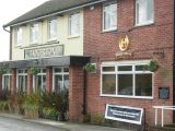
Geograph-1829496-by-JThomas.jpg|The Badger Box, Annesley / [http://www.geograph.org.uk/photo/1829496 J. Thomas, 16 Apr. 2010, Creative Commons, via Geograph.] | |||
geograph-2223070-by-Trevor-Rickard.jpg|The Badger Box; Greene King (Hungry Horse) pub on the busy Derby Road, with lots of parking space. A garage and general store next door. / [http://www.geograph.org.uk/photo/2223070 Trevor Rickard, 16 OCt. 2010, Creative Commons, via Geograph.] | |||
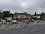
geograph-2151149-by-Stephen-McKay.jpg|The Badger Box, Annesley | |||
This unusually named pub is now owned by Greene King and branded as a 'Hungry Horse' / [http://www.geograph.org.uk/photo/2151149 Stephen McKay, 5 Nov. 2010, Creative Commons, via Geograph.] | |||
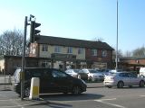
geograph-895154-by-Phil-Evans.jpg|Badger Box Public House, Annesley, on the A611 between Hucknall and Mansfield / [http://www.geograph.org.uk/photo/895154 Phil Evans, 24 Jul. 2008, Creative Commons, via Geograph.] | |||
geograph-3470520-by-Tim-Glover.jpg|Badger Box / [http://www.geograph.org.uk/photo/3470520 Tim Glover, 13 Apr. 2013, Creative Commons, via Geograph.] | |||
geograph-5000244-by-Chris-Morgan.jpg|The Badger Box, Annesley, a Hungry Horse pub / [http://www.geograph.org.uk/photo/5000244 Chris Morgan, 3 may 2016, Creative Commons, via Geograph.] | |||
</gallery> | |||
</div> | </div> | ||
{{ | {{PlaceNamesItemNavigation}} | ||
Latest revision as of 15:30, 5 May 2022
| Locality | |
|---|---|
| Coordinate | 53.079, -1.2428 |
| Adm. div. | Nottinghamshire |
| Vicinity | 2.9 km SE of central Kirkby in Ashfield |
| Type | Public house |
| Interest | Robin Hood name |
| Status | Defunct |
| First Record | 1878 |
| A.k.a. | Badger Box |

By Henrik Thiil Nielsen, 2016-10-04. Revised by Henrik Thiil Nielsen, 2022-05-05.
The Robin Hood, a public house, was located on the corner of Derby Road and Forest Road in Annesley, not quite 3 km SE of central Kirkby in Ashfield. 675 m NNE of the public house was found Robin Hood's Cave (Kirkby in Ashfield), while Robin Hood's Hills and Robin Hood's Chair are found c. 1.2 km NNE of the Robin Hood. The Robin Hood is indicated on O.S. maps of the area published 1878–c. 1948 (see Maps section below). There is a recently built pub/restaurant named the Badger Box on Derby Road, but this is ten metres or so north of the site of the Robin Hood, unless the course of Forest Road was changed a little.
Information on publicans for the years 1925-41 can be found at Pub History.[1]
Gazetteers
- Not included in Dobson, R. B., ed.; Taylor, J., ed. Rymes of Robyn Hood: an Introduction to the English Outlaw (London, 1976), pp. 293-311.
Sources
Maps
- 25" O.S. map Nottinghamshire XXXII.3 (1878; surveyed 1877)
- 25" O.S. map Nottinghamshire XXXII.3 (1900; rev. 1898-99)
- 25" O.S. map Nottinghamshire XXXII.3 (1900; rev. 1898-99) (georeferenced)
- 25" O.S. map Nottinghamshire XXXII.3 (1915; rev. 1914)
- 25" O.S. map Nottinghamshire XXXII.3 (1947; rev. 1938-39)
- 6" O.S. map Derbyshire XLI (1921; rev. 1913-14)
- 6" O.S. map Nottinghamshire XXXII.NE (1886; surveyed 1878-79)
- 6" O.S. map Nottinghamshire XXIII.NE (1900; rev. 1898-99) (georeferenced)
- 6" O.S. map Nottinghamshire XXXII.NE (1900; rev. 1898-99)
- 6" O.S. map Nottinghamshire XXXII.NE (1920; rev. 1914)
- 6" O.S. map Nottinghamshire XXXII.NE (1921; rev. 1914)
- 6" O.S. map Nottinghamshire XXXII.NE (c. 1948; rev. 1938).
Also see
Notes
- ↑ Pub History: Robin Hood, East Kirkby, Annesley Woodhouse, Nottinghamshire. "East Kirkby" is a mistake, There is one in Lincolnshire, but none near Annesley.
- ↑ As previously noted, "East Kirkby" is a mistake,
Image gallery
Click any image to display it in the lightbox, where you can navigate between images by clicking in the right or left side of the current image.
The Badger Box, Annesley / J. Thomas, 16 Apr. 2010, Creative Commons, via Geograph.
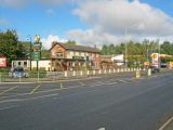
The Badger Box; Greene King (Hungry Horse) pub on the busy Derby Road, with lots of parking space. A garage and general store next door. / Trevor Rickard, 16 OCt. 2010, Creative Commons, via Geograph.
The Badger Box, Annesley
Badger Box Public House, Annesley, on the A611 between Hucknall and Mansfield / Phil Evans, 24 Jul. 2008, Creative Commons, via Geograph.
The Badger Box, Annesley, a Hungry Horse pub / Chris Morgan, 3 may 2016, Creative Commons, via Geograph.


