Robin Hood (Havant): Difference between revisions
From International Robin Hood Bibliography
m (Text replacement - "map ''Hampshire and Isle of Wight'' " to "map ''Hampshire & Isle of Wight'' ") |
m (Text replacement - "* 25" map" to "* 25" O.S. map") |
||
| Line 12: | Line 12: | ||
* [https://historicengland.org.uk/listing/the-list/list-entry/1340201?section=official-list-entry Historic England: The Robin Hood P.H. 6 Homewell: Official List Entry] | * [https://historicengland.org.uk/listing/the-list/list-entry/1340201?section=official-list-entry Historic England: The Robin Hood P.H. 6 Homewell: Official List Entry] | ||
== Maps == | == Maps == | ||
* 25" map ''Hampshire & Isle of Wight'' LXXVI.11 (''c.'' 1869; surveyed 1858–65). No copy in NLS | * 25" O.S. map ''Hampshire & Isle of Wight'' LXXVI.11 (''c.'' 1869; surveyed 1858–65). No copy in NLS | ||
* 25" map ''Hampshire & Isle of Wight'' LXXVI.11 (''c.'' 1897; rev. ''c.'' 1895). No copy in NLS | * 25" O.S. map ''Hampshire & Isle of Wight'' LXXVI.11 (''c.'' 1897; rev. ''c.'' 1895). No copy in NLS | ||
* [https://maps.nls.uk/geo/explore/#zoom=17&lat=50.85202&lon=-0.98402&layers=168&b=5 25" O.S. map ''Hampshire & Isle of Wight'' LXXVI.11 (1909; rev. 1907)] (georeferenced) | * [https://maps.nls.uk/geo/explore/#zoom=17&lat=50.85202&lon=-0.98402&layers=168&b=5 25" O.S. map ''Hampshire & Isle of Wight'' LXXVI.11 (1909; rev. 1907)] (georeferenced) | ||
* [https://maps.nls.uk/view/105988708#zoom=5&lat=9998&lon=5572&layers=BT 25" O.S. map ''Hampshire & Isle of Wight'' LXXVI.11 (1909; rev. 1907)] | * [https://maps.nls.uk/view/105988708#zoom=5&lat=9998&lon=5572&layers=BT 25" O.S. map ''Hampshire & Isle of Wight'' LXXVI.11 (1909; rev. 1907)] | ||
Latest revision as of 16:43, 8 May 2022
| Locality | |
|---|---|
| Coordinate | 50.851185, -0.982582 |
| Adm. div. | Hampshire |
| Vicinity | 6 Homewell, Havant |
| Type | Public house |
| Interest | Robin Hood name |
| Status | Extant |
| First Record | |
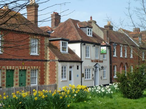
The Robin Hood in Havant.

The Robin Hood, Havant / Robin Webster, 30 Mar. 2014, Creative Commons.
By Henrik Thiil Nielsen, 2022-05-02. Revised by Henrik Thiil Nielsen, 2022-05-08.
Still in business, the Robin Hood at 6 Homewell in Havant, Hampshire, dates back to the 19th century.
According to the pub's own website, the establishment dates back to the 18th century,[1] but the pub is officially listed as a grade II building dating back to the 19th century.[2] A few of the early maps listed below have a 'P.H.' indication, but none gives the name of the pub.
Gazetteers
- Not included in Dobson, R. B., ed.; Taylor, J., ed. Rymes of Robyn Hood: an Introduction to the English Outlaw (London, 1976), pp. 293-311.
Sources
Maps
- 25" O.S. map Hampshire & Isle of Wight LXXVI.11 (c. 1869; surveyed 1858–65). No copy in NLS
- 25" O.S. map Hampshire & Isle of Wight LXXVI.11 (c. 1897; rev. c. 1895). No copy in NLS
- 25" O.S. map Hampshire & Isle of Wight LXXVI.11 (1909; rev. 1907) (georeferenced)
- 25" O.S. map Hampshire & Isle of Wight LXXVI.11 (1909; rev. 1907)
- 25" O.S. map Hampshire & Isle of Wight LXXVI.11 (1932; rev. 1931)
- 6" O.S. map Hampshire & Isle of Wight LXXVI (1870; surveyed 1859–66)
- 6" O.S. map Sussex LX (1889; surveyed 1875–77)
- 6" O.S. map Sussex LX.NW (1899; rev. 1895–96)
- 6" O.S. map Hampshire & Isle of Wight LXXVI.SE (1898; rev. 1895–96)
- 6" O.S. map Sussex LX.NW (1899; rev. 1895–96) (georeferenced)
- 6" O.S. map Hampshire & Isle of Wight LXXVI.SE (1910; rev. 1907)
- 6" O.S. map Sussex LX.NW (1914; rev. 1910)
- 6" O.S. map Hampshire & Isle of Wight LXXVI.SE (c. 1933; rev. 1930–31)
- 6" O.S. map Sussex LX.NW (c. 1934; rev. 1932)
- 6" O.S. map Sussex LX.NW (c. 1939; rev. 1932)
- 6" O.S. map Hampshire & Isle of Wight LXXVI.SE (c. 1944; rev. 1931–32)
- 6" O.S. map Sussex LX.NW (c. 1945; rev. 1932)
- 6" O.S. map Hampshire & Isle of Wight LXXVI.SE (c. 1946; rev. 1938–42).
Background
- The Robin Hood (the pub's website).
Also see
Notes
