
Robin Hood (Guildford): Difference between revisions
m (Text replacement - "=== Background ===" to "== Background ==") |
m (Text replacement - "UK Pub History" to "Pub History") |
||
| (27 intermediate revisions by 2 users not shown) | |||
| Line 1: | Line 1: | ||
__NOTOC__{{ | __NOTOC__{{PlaceNamesItemTop|Lat=51.235909|Lon=-0.568683|AdministrativeDivision=Surrey|Vicinity=19 Sydenham Road, Guildford, Surrey|Type=Public house|Interest=Robin Hood name|Status=Extant|Demonym=|Riding=|GreaterLondon=|Year=1878|Aka=|Century=|Cluster1=|Cluster2=|Cluster3=|Image=geograph-4340924-by-Len-Williams.jpg|Postcards=|ExtraCat1=|ExtraCat2=|ExtraCat3=|ExtraCat4=|ExtraCat5=|ExtraLink1=|ExtraLink2=|ExtraLink3=|ExtraLink4=|ExtraLink5=|ExtraLinkName1=|ExtraLinkName2=|ExtraLinkName3=|ExtraLinkName4=|ExtraLinkName5=|GeopointPrefix=|GeopointSuffix=|StatusSuffix=|DatePrefix=|DateSuffix=}} | ||
{{#display_map:{{#var:Coords}}~{{#replace:{{PAGENAME}}|'|'}}|width=34%}}<div class="pnMapLegend">The Robin Hood.</div> | {{#display_map:{{#var:Coords}}~{{#replace:{{PAGENAME}}|'|'}}|width=34%|enablefullscreen=yes}}<div class="pnMapLegend">The Robin Hood.</div> | ||
[[File:{{#var: | [[File:{{#var:Image}}|thumb|right|500px|Robin Hood, Sydenham Road, reopened / [http://www.geograph.org.uk/photo/2207350 L.S. Wilson, 18 Dec. 2010, Creative Commons, via Geograph.]]]<div class="no-img"> | ||
<p id="byline">By Henrik Thiil Nielsen, 2013-08-07. Revised by {{#realname:{{REVISIONUSER}}}}, {{REVISIONYEAR}}-{{REVISIONMONTH}}-{{REVISIONDAY2}}.</p> | <p id="byline">By Henrik Thiil Nielsen, 2013-08-07. Revised by {{#realname:{{REVISIONUSER}}}}, {{REVISIONYEAR}}-{{REVISIONMONTH}}-{{REVISIONDAY2}}.</p> | ||
The Robin Hood at 19 Sydenham Road, Guildford, Surrey, is listed in Kelly's ''Directory'' for 1878, and it probably is not much older than this, for the building is said to date from ''c.'' 1865.<ref>[http://www.geograph.org.uk/photo/3047265 Geograph: Robin Hood.]</ref> The pub closed in the spring of 2010 but reopened later same year under new management.<ref>[http://www.geograph.org.uk/photo/2207358 Geograph: Robin Hood (2), Sydenham Road.]</ref> Information on publicans for the period 1878-1937 can be found at Pub History.<ref>[https://pubwiki.co.uk/SurreyPubs/Guildford/RobinHood.shtml Pub History: Robin Hood, 38 Sydenham Road, Guildford, Surrey.]</ref>{{PlaceNamesItemAllusionsAndRecords}} | |||
The Robin Hood | |||
== Gazetteers == | |||
* Not included in {{:Dobson, Richard Barrie 1976a|Dobson & Taylor}}, pp. 293-311. | |||
== Sources == | |||
* [https://pubwiki.co.uk/SurreyPubs/Guildford/RobinHood.shtml Pub History: Robin Hood, 38 Sydenham Road, Guildford, Surrey.] | |||
== Maps == | |||
* 25" O.S. map ''Surrey'' XXIII.16 (''c.'' 1873; surveyed ''c.'' 1870-71). No copy in NLS | |||
* [https://maps.nls.uk/geo/explore/#zoom=18&lat=51.2363&lon=-0.5684&layers=168&b=5 25" O.S. map ''Surrey'' XXIII.16 (1896; rev. 1895)] (georeferenced) | |||
* [https://maps.nls.uk/view/103315522#zoom=5&lat=2529&lon=13372&layers=BT 25" O.S. map ''Surrey'' XXIII.16 (1896; rev. 1895)] | |||
* [https://maps.nls.uk/view/103315519#zoom=5&lat=2439&lon=12934&layers=BT 25" O.S. map ''Surrey'' XXIII.16 (1916; rev. 1913)] | |||
* [https://maps.nls.uk/view/103315516#zoom=5&lat=2633&lon=13308&layers=BT 25" O.S. map ''Surrey'' XXIII.16 (1935; rev. 1934)] | |||
* [https://maps.nls.uk/view/102347475#zoom=6&lat=1225&lon=14965&layers=BT 6" O.S. map ''Surrey'' XXIII (1873; surveyed 1870-71)] | |||
* [https://maps.nls.uk/geo/explore/#zoom=17&lat=51.2362&lon=-0.5697&layers=6&b=5 6" O.S. map ''Surrey'' XXIII.SE (1897; rev. 1895)] (georeferenced) | |||
* [https://maps.nls.uk/view/101437081#zoom=5&lat=1555&lon=7302&layers=BT 6" O.S. map ''Surrey'' XXIII.SE (1897; rev. 1895)] | |||
* [https://maps.nls.uk/view/101437078#zoom=5&lat=1759&lon=7449&layers=BT 6" O.S. map ''Surrey'' XXIII.SE (1920; rev. 1913)] | |||
* [https://maps.nls.uk/view/101437075#zoom=5&lat=1712&lon=7435&layers=BT 6" O.S. map ''Surrey'' XXIII.SE (1936; rev. 1934)] | |||
* [https://maps.nls.uk/view/101725319#zoom=5&lat=1720&lon=7318&layers=BT 6" O.S. map ''Surrey'' XXIII.SE (''c.'' 1944; rev. 1938)] | |||
* [https://maps.nls.uk/view/101725316#zoom=5&lat=1663&lon=7290&layers=BT 6" O.S. map ''Surrey'' XXIII.SE (''c.'' 1947; rev. 1938)] | |||
* [https://maps.nls.uk/view/101437072#zoom=5&lat=1795&lon=7195&layers=BT 6" O.S. map ''Surrey'' XXIII.SE (''c.'' 1954; rev. 1938).] | |||
== Background == | == Background == | ||
| Line 10: | Line 30: | ||
* [https://en.wikipedia.org/wiki/Guildford Wikipedia: Guildford.] | * [https://en.wikipedia.org/wiki/Guildford Wikipedia: Guildford.] | ||
{{ | {{PlaceNamesItemAlsoSee}} | ||
== Notes == | |||
<references/> | |||
</div> | |||
< | <div id="gallery"> | ||
{{ | {{ImageGalleryIntroduction}} | ||
<gallery widths="195px"> | <gallery widths="195px"> | ||
geograph-4340924-by-Len-Williams.jpg|The Robin Hood, Guildford, reopened / [http://www.geograph.org.uk/photo/4340924 Len Williams, 6 Feb. 2015, Creative Commons, via Geograph.] | |||
geograph-2207358-by-L-S-Wilson.jpg|Robin Hood, Sydenham Road, reopened / [http://www.geograph.org.uk/photo/2207358 L.S. Wilson, 18 Dec. 2010, Creative Commons, via Geograph.] | |||
geograph-2207350-by-L-S-Wilson.jpg|Robin Hood, Sydenham Road, reopened / [http://www.geograph.org.uk/photo/2207350 L.S. Wilson, 18 Dec. 2010, Creative Commons, via Geograph.] | |||
geograph-2207384-by-L-S-Wilson.jpg|Sign of the Robin Hood, Sydenham Road / [http://www.geograph.org.uk/photo/2207384 P.L. Chadwick, 18 Dec. 2010, Creative Commons, via Geograph.] | |||
geograph-3047265-by-Colin-Smith.jpg|The Robin Hood / [http://www.geograph.org.uk/photo/3047265 Colin Smith, 19 Jul. 2012, Creative Commons, via Geograph.] | |||
geograph-2045981-by-N-Chadwick.jpg|Robin Hood, Sydenham Road, closed / [http://www.geograph.org.uk/photo/2045981 N. Chadwick, 3 Jul. 2010, Creative Commons, via Geograph.] | |||
geograph-2100135-by-P-L-Chadwick.jpg|Robin Hood, Sydenham Road, closed / [http://www.geograph.org.uk/photo/2100135 P.L. Chadwick, 4. Oct. 2010, Creative Commons, via Geograph.] | |||
geograph-2100149-by-P-L-Chadwick.jpg|Sign of the Robin Hood, Sydenham Road / [http://www.geograph.org.uk/photo/2100149 P.L. Chadwick, 4. Oct. 2010, Creative Commons, via Geograph.] | |||
geograph-2100146-by-P-L-Chadwick.jpg|Robin Hood, Sydenham Road, closed / [http://www.geograph.org.uk/photo/2100146 P.L. Chadwick, 4. Oct. 2010, Creative Commons, via Geograph.] | |||
robin-hood-guildford-surrey-google-earth-street-view-1.jpg|The Robin Hood, from the north­west / Google Earth Street View | |||
robin-hood-guildford-surrey-google-earth-street-view-2.jpg|The Robin Hood, from the northeast / Google Earth Street View | |||
robin-hood-guildford-surrey-google-earth-street-view-3.jpg|The Robin Hood, from the west / Google Earth Street View | |||
</gallery> | </gallery> | ||
</div> | |||
{{ | {{PlaceNamesItemNavigation}} | ||
Latest revision as of 15:29, 5 May 2022
| Locality | |
|---|---|
| Coordinate | 51.235909, -0.568683 |
| Adm. div. | Surrey |
| Vicinity | 19 Sydenham Road, Guildford, Surrey |
| Type | Public house |
| Interest | Robin Hood name |
| Status | Extant |
| First Record | 1878 |

By Henrik Thiil Nielsen, 2013-08-07. Revised by Henrik Thiil Nielsen, 2022-05-05.
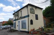
The Robin Hood at 19 Sydenham Road, Guildford, Surrey, is listed in Kelly's Directory for 1878, and it probably is not much older than this, for the building is said to date from c. 1865.[1] The pub closed in the spring of 2010 but reopened later same year under new management.[2] Information on publicans for the period 1878-1937 can be found at Pub History.[3]
Gazetteers
- Not included in Dobson, R. B., ed.; Taylor, J., ed. Rymes of Robyn Hood: an Introduction to the English Outlaw (London, 1976), pp. 293-311.
Sources
Maps
- 25" O.S. map Surrey XXIII.16 (c. 1873; surveyed c. 1870-71). No copy in NLS
- 25" O.S. map Surrey XXIII.16 (1896; rev. 1895) (georeferenced)
- 25" O.S. map Surrey XXIII.16 (1896; rev. 1895)
- 25" O.S. map Surrey XXIII.16 (1916; rev. 1913)
- 25" O.S. map Surrey XXIII.16 (1935; rev. 1934)
- 6" O.S. map Surrey XXIII (1873; surveyed 1870-71)
- 6" O.S. map Surrey XXIII.SE (1897; rev. 1895) (georeferenced)
- 6" O.S. map Surrey XXIII.SE (1897; rev. 1895)
- 6" O.S. map Surrey XXIII.SE (1920; rev. 1913)
- 6" O.S. map Surrey XXIII.SE (1936; rev. 1934)
- 6" O.S. map Surrey XXIII.SE (c. 1944; rev. 1938)
- 6" O.S. map Surrey XXIII.SE (c. 1947; rev. 1938)
- 6" O.S. map Surrey XXIII.SE (c. 1954; rev. 1938).
Background
Also see
Notes
Image gallery
Click any image to display it in the lightbox, where you can navigate between images by clicking in the right or left side of the current image.
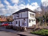
The Robin Hood, Guildford, reopened / Len Williams, 6 Feb. 2015, Creative Commons, via Geograph.
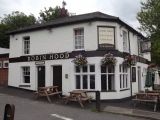
Robin Hood, Sydenham Road, reopened / L.S. Wilson, 18 Dec. 2010, Creative Commons, via Geograph.
Robin Hood, Sydenham Road, reopened / L.S. Wilson, 18 Dec. 2010, Creative Commons, via Geograph.

Sign of the Robin Hood, Sydenham Road / P.L. Chadwick, 18 Dec. 2010, Creative Commons, via Geograph.
The Robin Hood / Colin Smith, 19 Jul. 2012, Creative Commons, via Geograph.
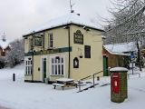
Robin Hood, Sydenham Road, closed / N. Chadwick, 3 Jul. 2010, Creative Commons, via Geograph.
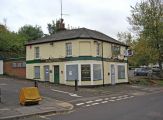
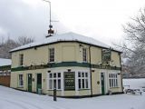
Robin Hood, Sydenham Road, closed / P.L. Chadwick, 4. Oct. 2010, Creative Commons, via Geograph.
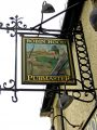
Sign of the Robin Hood, Sydenham Road / P.L. Chadwick, 4. Oct. 2010, Creative Commons, via Geograph.
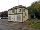
Robin Hood, Sydenham Road, closed / P.L. Chadwick, 4. Oct. 2010, Creative Commons, via Geograph.
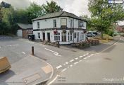
The Robin Hood, from the northwest / Google Earth Street View
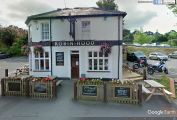
The Robin Hood, from the northeast / Google Earth Street View
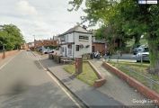
The Robin Hood, from the west / Google Earth Street View


