
Robin Hood (Gosport): Difference between revisions
From International Robin Hood Bibliography
mNo edit summary |
mNo edit summary |
||
| (13 intermediate revisions by the same user not shown) | |||
| Line 1: | Line 1: | ||
__NOTOC__{{ | __NOTOC__{{PlaceNamesItemTop|Lat=50.790477|Lon=-1.134056|AdministrativeDivision=Hampshire|Vicinity=1 Mayfield Road, Gosport|Type=Public house|Interest=Robin Hood name| | ||
Status=Defunct|Demonym=|Riding=|GreaterLondon=|Year=1891|Aka=|Century=|Cluster1=Portsmouth|Cluster2=|Cluster3=|Image=robin-hood-gosport-google-earth-street-view.jpg|Postcards=|ExtraCat1=|ExtraCat2=|ExtraCat3=|ExtraCat4=|ExtraCat5=|ExtraLink1=|ExtraLink2=|ExtraLink3=|ExtraLink4=|ExtraLink5=|ExtraLinkName1=|ExtraLinkName2=|ExtraLinkName3=|ExtraLinkName4=|ExtraLinkName5=|GeopointPrefix=|GeopointSuffix=|VicinitySuffix=|StatusSuffix=|DatePrefix=|DateSuffix=}} | Status=Defunct|Demonym=|Riding=|GreaterLondon=|Year=1891|Aka=|Century=|Cluster1=Portsmouth|Cluster2=|Cluster3=|Image=robin-hood-gosport-google-earth-street-view.jpg|Postcards=|ExtraCat1=|ExtraCat2=|ExtraCat3=|ExtraCat4=|ExtraCat5=|ExtraLink1=|ExtraLink2=|ExtraLink3=|ExtraLink4=|ExtraLink5=|ExtraLinkName1=|ExtraLinkName2=|ExtraLinkName3=|ExtraLinkName4=|ExtraLinkName5=|GeopointPrefix=|GeopointSuffix=|VicinitySuffix=|StatusSuffix=|DatePrefix=|DateSuffix=}} | ||
{{#display_map:{{#var:Coords}}~{{#replace:{{PAGENAME}}|'|'}}|width=34%}}<div class="pnMapLegend">{{PAGENAME}}.</div> | {{#display_map:{{#var:Coords}}~{{#replace:{{PAGENAME}}|'|'}}|width=34%|fullscreen=yes}}<div class="pnMapLegend">{{PAGENAME}}.</div> | ||
[[File:{{#var: | [[File:{{#var:Image}}|thumb|right|500px|The former Robin Hood / Google Earth Street View.]] | ||
<p id="byline">By Henrik Thiil Nielsen, 2020-05-27. Revised by {{#realname:{{REVISIONUSER}}}}, {{REVISIONYEAR}}-{{REVISIONMONTH}}-{{REVISIONDAY2}}.</p><div class="no-img"> | <p id="byline">By Henrik Thiil Nielsen, 2020-05-27. Revised by {{#realname:{{REVISIONUSER}}}}, {{REVISIONYEAR}}-{{REVISIONMONTH}}-{{REVISIONDAY2}}.</p><div class="no-img"> | ||
The Robin Hood at 1 Mayfield Road, Gosport, first appears in the records in 1891. It closed in 2006. | The Robin Hood at 1 Mayfield Road, Gosport, first appears in the records in 1891. It closed in 2006. | ||
Information on publicans etc. for the years 1891–1927 can be found at Pub | Information on publicans etc. for the years 1891–1927 can be found at Pub History.<ref>[https://pubwiki.co.uk/Hampshire/Gosport/RobinHood.shtml Pub Wiki: Robin Hood, 1 Mayfield road, Gosport, Hampshire]; [https://pubwiki.co.uk/Hampshire/Hampshire1911/Hampshire1911QR.shtml Public Houses, Inns & Taverns of Hampshire in 1911 - QR]; for closing date see [https://www.closedpubs.co.uk/hampshire/gosport_robinhood.html Closed Pubs: Hampshire > Gosport > Robin Hood.]</ref> | ||
{{ | {{PlaceNamesItemAllusionsAndRecords}} | ||
== Gazetteers == | == Gazetteers == | ||
* Not included in {{:Dobson, Richard Barrie 1976a}}, pp. 293-311. | * Not included in {{:Dobson, Richard Barrie 1976a}}, pp. 293-311. | ||
== Sources == | == Sources == | ||
* [https://www.closedpubs.co.uk/hampshire/gosport_robinhood.html Closed Pubs: Hampshire > Gosport > Robin Hood.] | * [https://www.closedpubs.co.uk/hampshire/gosport_robinhood.html Closed Pubs: Hampshire > Gosport > Robin Hood.] | ||
* [https://pubwiki.co.uk/Hampshire/Gosport/RobinHood.shtml Pub | * [https://pubwiki.co.uk/Hampshire/Gosport/RobinHood.shtml Pub History: Robin Hood, 1 Mayfield road, Gosport, Hampshire] | ||
** [https://pubwiki.co.uk/Hampshire/Hampshire1911/Hampshire1911QR.shtml Pub History: Public Houses, Inns & Taverns of Hampshire in 1911 - QR.] | |||
== Maps == | == Maps == | ||
* 25" O.S. map ''Hampshire | * 25" O.S. map ''Hampshire & Isle of Wight'' LXXXIII.10 (''c.'' 1860; surveyed 1856). No copy in NLS | ||
* [https://maps.nls.uk/geo/explore/#zoom=18&lat=50.79079&lon=-1.13495&layers=168&b=5 25" O.S. map ''Hampshire | * [https://maps.nls.uk/geo/explore/#zoom=18&lat=50.79079&lon=-1.13495&layers=168&b=5 25" O.S. map ''Hampshire & Isle of Wight'' LXXXIII.10 (1898; rev. 1896)] (georeferenced) | ||
* [https://maps.nls.uk/view/105989386#zoom=6&lat=7417&lon=14787&layers=BT 25" O.S. map ''Hampshire | * [https://maps.nls.uk/view/105989386#zoom=6&lat=7417&lon=14787&layers=BT 25" O.S. map ''Hampshire & Isle of Wight'' LXXXIII.10 (1898; rev. 1896)] | ||
* [https://maps.nls.uk/view/105989383#zoom=6&lat=7727&lon=14428&layers=BT 25" O.S. map ''Hampshire | * [https://maps.nls.uk/view/105989383#zoom=6&lat=7727&lon=14428&layers=BT 25" O.S. map ''Hampshire & Isle of Wight'' LXXXIII.10 (1910; rev. 1906)] | ||
* [https://maps.nls.uk/view/105989380#zoom=6&lat=7505&lon=14467&layers=BT 25" O.S. map ''Hampshire | * [https://maps.nls.uk/view/105989380#zoom=6&lat=7505&lon=14467&layers=BT 25" O.S. map ''Hampshire & Isle of Wight'' LXXXIII.10 (1932; rev. 1931)] | ||
* [https://maps.nls.uk/view/105989377#zoom=6&lat=7449&lon=14589&layers=BT 25" O.S. map ''Hampshire | * [https://maps.nls.uk/view/105989377#zoom=6&lat=7449&lon=14589&layers=BT 25" O.S. map ''Hampshire & Isle of Wight'' LXXXIII.10 (1939; rev. 1936)] | ||
* [https://maps.nls.uk/geo/explore/#zoom=17&lat=50.79091&lon=-1.13454&layers=6&b=5 6" O.S. map ''Hampshire & Isle of Wight'' LXXXIII.SW (1898; rev. 1896)] (georeferenced) | * [https://maps.nls.uk/geo/explore/#zoom=17&lat=50.79091&lon=-1.13454&layers=6&b=5 6" O.S. map ''Hampshire & Isle of Wight'' LXXXIII.SW (1898; rev. 1896)] (georeferenced) | ||
* [https://maps.nls.uk/view/102343170#zoom=5&lat=4620&lon=7079&layers=BT 6" O.S. map ''Hampshire & Isle of Wight'' LXXXIII (''c.'' 1871; surveyed 1856)] | * [https://maps.nls.uk/view/102343170#zoom=5&lat=4620&lon=7079&layers=BT 6" O.S. map ''Hampshire & Isle of Wight'' LXXXIII (''c.'' 1871; surveyed 1856)] | ||
| Line 34: | Line 35: | ||
<!--== Brief mention == | <!--== Brief mention == | ||
* --> | * --> | ||
{{ | {{PlaceNamesItemAlsoSee}} | ||
== Notes == | == Notes == | ||
| Line 41: | Line 42: | ||
</div> | </div> | ||
{{ | {{ImageGalleryIntroduction}} | ||
<gallery widths="195px"> | <gallery widths="195px"> | ||
robin-hood-gosport-google-earth-street-view.jpg|The former Robin Hood / Google Earth Street View. | robin-hood-gosport-google-earth-street-view.jpg|The former Robin Hood / Google Earth Street View. | ||
| Line 49: | Line 50: | ||
{{ | {{PlaceNamesItemNavigation}} | ||
Latest revision as of 15:22, 5 May 2022
| Locality | |
|---|---|
| Coordinate | 50.790477, -1.134056 |
| Adm. div. | Hampshire |
| Vicinity | 1 Mayfield Road, Gosport |
| Type | Public house |
| Interest | Robin Hood name |
| Status | Defunct |
| First Record | 1891 |
Robin Hood (Gosport).

By Henrik Thiil Nielsen, 2020-05-27. Revised by Henrik Thiil Nielsen, 2022-05-05.
The Robin Hood at 1 Mayfield Road, Gosport, first appears in the records in 1891. It closed in 2006.
Information on publicans etc. for the years 1891–1927 can be found at Pub History.[1]
Gazetteers
- Not included in Dobson, R. B., ed.; Taylor, J., ed. Rymes of Robyn Hood: an Introduction to the English Outlaw (London, 1976), pp. 293-311.
Sources
- Closed Pubs: Hampshire > Gosport > Robin Hood.
- Pub History: Robin Hood, 1 Mayfield road, Gosport, Hampshire
Maps
- 25" O.S. map Hampshire & Isle of Wight LXXXIII.10 (c. 1860; surveyed 1856). No copy in NLS
- 25" O.S. map Hampshire & Isle of Wight LXXXIII.10 (1898; rev. 1896) (georeferenced)
- 25" O.S. map Hampshire & Isle of Wight LXXXIII.10 (1898; rev. 1896)
- 25" O.S. map Hampshire & Isle of Wight LXXXIII.10 (1910; rev. 1906)
- 25" O.S. map Hampshire & Isle of Wight LXXXIII.10 (1932; rev. 1931)
- 25" O.S. map Hampshire & Isle of Wight LXXXIII.10 (1939; rev. 1936)
- 6" O.S. map Hampshire & Isle of Wight LXXXIII.SW (1898; rev. 1896) (georeferenced)
- 6" O.S. map Hampshire & Isle of Wight LXXXIII (c. 1871; surveyed 1856)
- 6" O.S. map Hampshire & Isle of Wight LXXXIII.SW (1898; rev. 1896)
- 6" O.S. map Hampshire & Isle of Wight LXXXIII.SW (1910; rev. 1906–07)
- 6" O.S. map Hampshire & Isle of Wight LXXXIII.SW (c. 1933; rev. 1931)
- 6" O.S. map Hampshire & Isle of Wight LXXXIII.SW (c. 1942; rev. 1940)
- 6" O.S. map Hampshire & Isle of Wight LXXXIII.SW (c. 1943; rev. 1938)
- 6" O.S. map Hampshire & Isle of Wight LXXXIII.SW (c. 1946; rev. 1938).
Also see
Notes
Image gallery
Click any image to display it in the lightbox, where you can navigate between images by clicking in the right or left side of the current image.
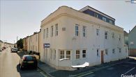
The former Robin Hood / Google Earth Street View.
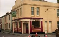
The Robin Hood / Barry Shimmon, 15 Mar. 1987; Creative Commons, via Geograph.
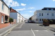
Mayfield Road with the former Robin Hood right / Barry Shimmon, 16 Apr. 2012; Creative Commons, via Geograph.
_-_geograph.org.uk_-_1445260.jpg)