
Robin Hood (Enfield): Difference between revisions
m (Text replacement - "<!-- {{ImgGalleryIntro}} <gallery widths="195px"> FOR EACH IMAGE: File:_FILENAME.jpg|_LEGEND / [_URL _PHOTOGRAPHER, _DAY _MON. _YEAR, Creative Commons.] </gallery>-->" to "") |
m (Text replacement - "ImgGalleryIntro" to "ImageGalleryIntroduction") |
||
| (41 intermediate revisions by 2 users not shown) | |||
| Line 1: | Line 1: | ||
__NOTOC__{{ | __NOTOC__{{PlaceNamesItemTop|Lat=51.676189|Lon=-0.126530|AdministrativeDivision=Middlesex|Vicinity=The Ridgeway, Botany Bay, Enfield|Type=Public house|Interest=Robin Hood name|Status=Extant|Demonym=|Riding=|GreaterLondon=Yes|Year=1881|Aka=|Century=|Cluster1=|Cluster2=|Cluster3=|Image=geograph-5208055-by-JThomas.jpg|Postcards=Yes|ExtraCat1=|ExtraCat2=|ExtraCat3=|ExtraCat4=|ExtraCat5=|ExtraLink1=|ExtraLink2=|ExtraLink3=|ExtraLink4=|ExtraLink5=|ExtraLinkName1=|ExtraLinkName2=|ExtraLinkName3=|ExtraLinkName4=|ExtraLinkName5=|GeopointPrefix=|GeopointSuffix=|StatusSuffix=|DatePrefix=|DateSuffix=}} | ||
{{#display_map:{{#var:Coords}}|width=34%}}<div class="pnMapLegend">The Robin Hood.</div> | {{#display_map:{{#var:Coords}}~{{#replace:{{PAGENAME}}|'|'}}|width=34%|enablefullscreen=yes}}<div class="pnMapLegend">The Robin Hood.</div> | ||
<p id="byline">By Henrik Thiil Nielsen, 2013-08-07. Revised by {{#realname:{{REVISIONUSER}}}}, {{REVISIONYEAR}}-{{REVISIONMONTH}}-{{REVISIONDAY2}}.</p>< | [[File:{{#var:Image}}|thumb|right|500px|The Robin Hood public house, Enfield; on The Ridgeway (A1005) / [https://www.geograph.org.uk/photo/5208055 J. M. Thomas, 3 Sep. 2016, Creative Commons, via Geograph.]]]<div class="no-img"> | ||
<p id="byline">By Henrik Thiil Nielsen, 2013-08-07. Revised by {{#realname:{{REVISIONUSER}}}}, {{REVISIONYEAR}}-{{REVISIONMONTH}}-{{REVISIONDAY2}}.</p>Still going strong, the Robin Hood in Botany Bay, Enfield, was in existence by 1881.<ref>[https://pubwiki.co.uk/Middlesex/Enfield/RobinHoodBotany.shtml Pub History: Robin Hood, Botany Bay, Enfield.]</ref> | |||
It is doubtful if the pub is much older than this, for while it is included on O.S. maps published in the 1890s, it is missing from maps published in the 1860s (see Maps below). The excellent [https://pubwiki.co.uk/Middlesex/Enfield/RobinHoodBotany.shtml Pub Wiki] provides information on publicans and residents for the years 1881–1937.<ref>[https://pubwiki.co.uk/Middlesex/Enfield/RobinHoodBotany.shtml Pub History: Robin Hood, Botany Bay, Enfield.]</ref> | |||
{{PlaceNamesItemAllusionsAndRecords}} | |||
== Gazetteers == | |||
* Not included in {{:Dobson, Richard Barrie 1976a}}, pp. 293-311. | |||
== Sources == | |||
* [https://pubwiki.co.uk/Middlesex/Enfield/RobinHoodBotany.shtml Pub History: Robin Hood, Botany Bay, Enfield.] | |||
== Maps == | |||
* [https://maps.nls.uk/view/102345919#zoom=6&lat=2470&lon=5116&layers=BT 6" O.S. map ''Middlesex'' II (1868; surveyed 1866)] | |||
* [https://maps.nls.uk/geo/explore/#zoom=16&lat=51.6764&lon=-0.1283&layers=6&b=5 6" O.S. map ''Middlesex'' II.SW (1897; rev. 1895)] (georeferenced) | |||
* [https://maps.nls.uk/view/101454745#zoom=4&lat=2907&lon=4336&layers=BT 6" O.S. map ''Middlesex'' II.SW (1897; rev. 1895)] | |||
* [https://maps.nls.uk/view/101579844#zoom=4&lat=2951&lon=4410&layers=BT 6" O.S. map ''Hertfordshire'' XLI.SW (1920; rev. 1912)] | |||
* [https://maps.nls.uk/view/101579841#zoom=4&lat=2735&lon=4563&layers=BT 6" O.S. map ''Hertfordshire'' XLI.SW (''c.'' 1946; rev. 1938)] | |||
* [https://maps.nls.uk/view/103657397#zoom=4&lat=7484&lon=15634&layers=BT 25" O.S. map ''Middlesex'' II.13 (1866; surveyed 1866)] | |||
* [https://maps.nls.uk/geo/explore/#zoom=17&lat=51.6766&lon=-0.1287&layers=168&b=5 25" O.S. map ''Middlesex'' II.13 (1896; rev. 1895)] (georeferenced) | |||
* [https://maps.nls.uk/view/103657394#zoom=4&lat=7361&lon=15411&layers=BT 25" O.S. map ''Middlesex'' II.13 (1896; rev. 1895)] | |||
* [https://maps.nls.uk/view/103657391#zoom=4&lat=7237&lon=15654&layers=BT 25" O.S. map ''Middlesex'' II.13 (1913; rev. 1911)] | |||
* [https://maps.nls.uk/view/103657388#zoom=4&lat=7284&lon=15553&layers=BT 25" O.S. map ''Middlesex'' II.13 (1937; rev. 1935).] | |||
== Background == | |||
* [https://www.mcmullens.co.uk/robinhood McMullen: Robin Hood, Enfield] | |||
* [https://en.wikipedia.org/wiki/Botany_Bay,_London Wikipedia: Botany Bay.] | |||
{{PlaceNamesItemAlsoSee}} | |||
== Notes == | |||
<references/> | |||
</div> | |||
<div id="gallery"> | |||
{{ImageGalleryIntroduction}} | |||
<gallery widths="195px"> | |||
File:geograph-5208055-by-JThomas.jpg|The Robin Hood public house, Enfield; on The Ridgeway (A1005) / [https://www.geograph.org.uk/photo/5208055 J. M. Thomas, 3 Sep. 2016, Creative Commons, via Geograph.] | |||
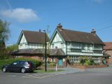
File:geograph-740042-by-Christine-Matthews.jpg|The Robin Hood, The Ridgeway, Enfield / [https://www.geograph.org.uk/photo/740042 Christine Matthews, 25 Mar. 2008, Creative Commons, via Geograph.] | |||
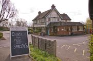
File:geograph-009967-by-Stephen-Dawson.jpg|The Robin Hood, Botany Bay / [https://www.geograph.org.uk/photo/9967 Stephen Dawson, 14 May 2005, Creative Commons, via Geograph.] | |||
File:geograph-3045705-by-David-Howard.jpg|Bus stop by the Robin Hood pub, The Ridgeway / [https://www.geograph.org.uk/photo/3045705 Davi Howard, 19 July 2012, Creative Commons, via Geograph.] | |||
File:geograph-5208056-by-JThomas.jpg|Sign for the Robin Hood public house, Enfield / [https://www.geograph.org.uk/photo/5208056 J. M. Thomas, 3 Sep. 2016, Creative Commons, via Geograph.] | |||
File:robin-hood-enfield-google-earth-street-view.jpg|The Robin Hood / Google Earth Street View. | |||
File:Anonymous 19xxzm-r.jpg|{{:Anonymous 19xxzm}}; dated ''c.'' 1910 cf. [https://pubwiki.co.uk/Middlesex/Enfield/RobinHoodBotany.shtml Pub History;] MS note "8/12" on dorse of IRHB copy may suggest 1912 / HTN collection | |||
</gallery> | |||
</div> | </div> | ||
{{ | {{PlaceNamesItemNavigation}} | ||
Latest revision as of 13:53, 7 January 2021
| Locality | |
|---|---|
| Coordinate | 51.676189, -0.12653 |
| Adm. div. | Middlesex, now Greater London |
| Vicinity | The Ridgeway, Botany Bay, Enfield |
| Type | Public house |
| Interest | Robin Hood name |
| Status | Extant |
| First Record | 1881 |

By Henrik Thiil Nielsen, 2013-08-07. Revised by Henrik Thiil Nielsen, 2021-01-07.
Still going strong, the Robin Hood in Botany Bay, Enfield, was in existence by 1881.[1]It is doubtful if the pub is much older than this, for while it is included on O.S. maps published in the 1890s, it is missing from maps published in the 1860s (see Maps below). The excellent Pub Wiki provides information on publicans and residents for the years 1881–1937.[2]
Gazetteers
- Not included in Dobson, R. B., ed.; Taylor, J., ed. Rymes of Robyn Hood: an Introduction to the English Outlaw (London, 1976), pp. 293-311.
Sources
Maps
- 6" O.S. map Middlesex II (1868; surveyed 1866)
- 6" O.S. map Middlesex II.SW (1897; rev. 1895) (georeferenced)
- 6" O.S. map Middlesex II.SW (1897; rev. 1895)
- 6" O.S. map Hertfordshire XLI.SW (1920; rev. 1912)
- 6" O.S. map Hertfordshire XLI.SW (c. 1946; rev. 1938)
- 25" O.S. map Middlesex II.13 (1866; surveyed 1866)
- 25" O.S. map Middlesex II.13 (1896; rev. 1895) (georeferenced)
- 25" O.S. map Middlesex II.13 (1896; rev. 1895)
- 25" O.S. map Middlesex II.13 (1913; rev. 1911)
- 25" O.S. map Middlesex II.13 (1937; rev. 1935).
Background
Also see
Notes
Image gallery
Click any image to display it in the lightbox, where you can navigate between images by clicking in the right or left side of the current image.
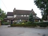
The Robin Hood public house, Enfield; on The Ridgeway (A1005) / J. M. Thomas, 3 Sep. 2016, Creative Commons, via Geograph.
The Robin Hood, The Ridgeway, Enfield / Christine Matthews, 25 Mar. 2008, Creative Commons, via Geograph.
The Robin Hood, Botany Bay / Stephen Dawson, 14 May 2005, Creative Commons, via Geograph.
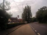
Bus stop by the Robin Hood pub, The Ridgeway / Davi Howard, 19 July 2012, Creative Commons, via Geograph.
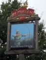
Sign for the Robin Hood public house, Enfield / J. M. Thomas, 3 Sep. 2016, Creative Commons, via Geograph.

The Robin Hood / Google Earth Street View.
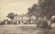
Anonymous. "The Robin Hood", Botany Bay ([s.l.], [s.d.]). Photographic postcard (monochrome). 138 x 87 mm.; dated c. 1910 cf. Pub History; MS note "8/12" on dorse of IRHB copy may suggest 1912 / HTN collection


