
Robin Hood (Egham): Difference between revisions
From International Robin Hood Bibliography
m (Text replacement - "=== Background ===" to "== Background ==") |
m (Text replacement - "UK Pub History" to "Pub History") |
||
| (22 intermediate revisions by 2 users not shown) | |||
| Line 1: | Line 1: | ||
__NOTOC__{{ | __NOTOC__{{PlaceNamesItemTop|Lat=51.425362|Lon=-0.531706|AdministrativeDivision=Surrey|Vicinity=152 Thorpe Lea Road, Egham|Type=Public house|Interest=Robin Hood name|Status=Extant|Demonym=|Riding=|GreaterLondon=|Year=1881|Aka=|Century=|Cluster1=|Cluster2=|Cluster3=|Image=robin-hood-egham-pub-website-1.jpg|Postcards=|ExtraCat1=|ExtraCat2=|ExtraCat3=|ExtraCat4=|ExtraCat5=|ExtraLink1=|ExtraLink2=|ExtraLink3=|ExtraLink4=|ExtraLink5=|ExtraLinkName1=|ExtraLinkName2=|ExtraLinkName3=|ExtraLinkName4=|ExtraLinkName5=|GeopointPrefix=|GeopointSuffix=|StatusSuffix=|DatePrefix=|DateSuffix=}} | ||
{{#display_map:{{#var:Coords}}~{{#replace:{{PAGENAME}}|'|'}}|width=34%}}<div class="pnMapLegend">The Robin Hood.</div> | {{#display_map:{{#var:Coords}}~{{#replace:{{PAGENAME}}|'|'}}|width=34%|enablefullscreen=yes}}<div class="pnMapLegend">The Robin Hood.</div> | ||
[[File:{{#var: | [[File:{{#var:Image}}|thumb|right|500px|The Robin Hood / [https://www.robinegham.co.uk/gallery/ Pub website.]]]<div class="no-img"> | ||
<p id="byline">By Henrik Thiil Nielsen, 2013-08-07. Revised by {{#realname:{{REVISIONUSER}}}}, {{REVISIONYEAR}}-{{REVISIONMONTH}}-{{REVISIONDAY2}}.</p> | <p id="byline">By Henrik Thiil Nielsen, 2013-08-07. Revised by {{#realname:{{REVISIONUSER}}}}, {{REVISIONYEAR}}-{{REVISIONMONTH}}-{{REVISIONDAY2}}.</p> | ||
The Robin hood in Egham is located on 152 Thorpe Lea Road, on the edge of Pooley green. Information on publicans for the years 1881 to 1938 can be found at Pub History.<ref>[https://pubwiki.co.uk/SurreyPubs/Egham/RobinHood.shtml Pub History: Robin Hood, 142 Thorpe Lea Road, Egham, Surrey.]</ref>{{PlaceNamesItemAllusionsAndRecords}} | |||
The Robin hood in Egham is located on 152 Thorpe Lea Road, on the edge of Pooley green. | |||
== Gazetteers == | |||
* Not included in {{:Dobson, Richard Barrie 1976a|Dobson & Taylor}}, pp. 293-311. | |||
== Sources == | |||
* [https://pubwiki.co.uk/SurreyPubs/Egham/RobinHood.shtml Pub History: Robin Hood, 142 Thorpe Lea Road, Egham, Surrey.] | |||
== Maps == | |||
* 25" O.S. map ''Surrey'' V.9 (''c.'' 1869; surveyed ''c.'' 1869). No copy in NLS | |||
* 25" O.S. map ''Surrey'' V.9 (''c.'' 1897; rev. ''c.'' 1895). No copy in NLS | |||
* [https://maps.nls.uk/geo/explore/#zoom=17&lat=51.4255&lon=-0.5308&layers=168&b=5 25" O.S. map ''Surrey'' V.9 (1914; rev. 1912)] (georeferenced) | |||
* [https://maps.nls.uk/view/103313650#zoom=4&lat=3171&lon=14418&layers=BT 25" O.S. map ''Surrey'' V.9 (1914; rev. 1912)] | |||
* [https://maps.nls.uk/view/103313647#zoom=4&lat=2909&lon=14622&layers=BT 25" O.S. map ''Surrey'' V.9 (1935; rev. 1934)] | |||
* [https://maps.nls.uk/view/103313644#zoom=4&lat=3290&lon=14619&layers=BT 25" O.S. map ''Surrey'' V.9 (1947; rev. 1940)] | |||
* [https://maps.nls.uk/view/102345985#zoom=5&lat=8685&lon=5393&layers=BT 6" O.S. map ''Middlesex'' XXIV (1869; surveyed 1864-65)] | |||
* [https://maps.nls.uk/view/102347421#zoom=5&lat=3534&lon=3737&layers=BT 6" O.S. map ''Surrey'' V (1872; surveyed 1869)] | |||
* [https://maps.nls.uk/view/102340001#zoom=5&lat=4584&lon=12241&layers=BT 6" O.S. map ''Berkshire'' XL (1881; surveyed 1868-69)] | |||
* [https://maps.nls.uk/view/101436394#zoom=5&lat=4198&lon=3952&layers=BT 6" O.S. map ''Surrey'' V.SW (1897; rev. 1894-95)] | |||
* [https://maps.nls.uk/geo/explore/#zoom=17&lat=51.4266&lon=-0.5315&layers=6&b=5 6" O.S. map ''Middlesex'' XXIV.NW (1899; rev. 1894-95)] (georeferenced) | |||
* [https://maps.nls.uk/view/101455084#zoom=5&lat=4449&lon=5645&layers=BT 6" O.S. map ''Middlesex'' XXIV.NW (1899; rev. 1894-95)] | |||
* [https://maps.nls.uk/view/101436391#zoom=6&lat=4319&lon=4184&layers=BT 6" O.S. map ''Surrey'' V.SW (1920; rev. 1912)] | |||
* [https://maps.nls.uk/view/101455081#zoom=6&lat=4549&lon=5667&layers=BT 6" O.S. map ''Middlesex'' XXIV.NW (1920; rev. 1913)] | |||
* [https://maps.nls.uk/view/101436388#zoom=5&lat=4266&lon=4140&layers=BT 6" O.S. map ''Surrey'' V.SW (''c.'' 1937; rev. 1934)] | |||
* [https://maps.nls.uk/view/101455078#zoom=5&lat=4573&lon=5596&layers=BT 6" O.S. map ''Middlesex'' XXIV.NW (1939; rev. 1935)] | |||
* [https://maps.nls.uk/view/101725172#zoom=5&lat=4435&lon=4121&layers=BT 6" O.S. map ''Surrey'' V.SW & SE (''c.'' 1944; rev. 1938)] | |||
* [https://maps.nls.uk/view/101455075#zoom=5&lat=4446&lon=5682&layers=BT 6" O.S. map ''Middlesex'' XXIV.NW (1947; rev. 1938)] | |||
* [https://maps.nls.uk/view/101436385#zoom=5&lat=4218&lon=4185&layers=BT 6" O.S. map ''Surrey'' V.SW (''c.'' 1947; rev. 1938).] | |||
== Background == | == Background == | ||
| Line 10: | Line 36: | ||
* [https://www.robinegham.co.uk/ Robin Hood, Egham] (the pub's website). | * [https://www.robinegham.co.uk/ Robin Hood, Egham] (the pub's website). | ||
{{ | {{PlaceNamesItemAlsoSee}} | ||
== Notes == | |||
<references/> | |||
</div> | </div> | ||
{{ | |||
<div id="gallery"> | |||
{{ImageGalleryIntroduction}} | |||
<gallery widths="195px"> | <gallery widths="195px"> | ||
File:robin-hood-egham-pub-website-1.jpg|The Robin Hood / [https://www.robinegham.co.uk/gallery/ Pub website.] | File:robin-hood-egham-pub-website-1.jpg|The Robin Hood / [https://www.robinegham.co.uk/gallery/ Pub website.] | ||
| Line 20: | Line 50: | ||
File:robin-hood-egham-pub-website-4.jpg|Pub interior. Is that Robin on the wall? / [https://www.robinegham.co.uk/gallery/ Pub website.] | File:robin-hood-egham-pub-website-4.jpg|Pub interior. Is that Robin on the wall? / [https://www.robinegham.co.uk/gallery/ Pub website.] | ||
</gallery> | </gallery> | ||
</div> | |||
{{PlaceNamesItemNavigation}} | |||
{{ | |||
Latest revision as of 15:29, 5 May 2022
| Locality | |
|---|---|
| Coordinate | 51.425362, -0.531706 |
| Adm. div. | Surrey |
| Vicinity | 152 Thorpe Lea Road, Egham |
| Type | Public house |
| Interest | Robin Hood name |
| Status | Extant |
| First Record | 1881 |
The Robin Hood.

The Robin Hood / Pub website.
By Henrik Thiil Nielsen, 2013-08-07. Revised by Henrik Thiil Nielsen, 2022-05-05.
The Robin hood in Egham is located on 152 Thorpe Lea Road, on the edge of Pooley green. Information on publicans for the years 1881 to 1938 can be found at Pub History.[1]
Gazetteers
- Not included in Dobson, R. B., ed.; Taylor, J., ed. Rymes of Robyn Hood: an Introduction to the English Outlaw (London, 1976), pp. 293-311.
Sources
Maps
- 25" O.S. map Surrey V.9 (c. 1869; surveyed c. 1869). No copy in NLS
- 25" O.S. map Surrey V.9 (c. 1897; rev. c. 1895). No copy in NLS
- 25" O.S. map Surrey V.9 (1914; rev. 1912) (georeferenced)
- 25" O.S. map Surrey V.9 (1914; rev. 1912)
- 25" O.S. map Surrey V.9 (1935; rev. 1934)
- 25" O.S. map Surrey V.9 (1947; rev. 1940)
- 6" O.S. map Middlesex XXIV (1869; surveyed 1864-65)
- 6" O.S. map Surrey V (1872; surveyed 1869)
- 6" O.S. map Berkshire XL (1881; surveyed 1868-69)
- 6" O.S. map Surrey V.SW (1897; rev. 1894-95)
- 6" O.S. map Middlesex XXIV.NW (1899; rev. 1894-95) (georeferenced)
- 6" O.S. map Middlesex XXIV.NW (1899; rev. 1894-95)
- 6" O.S. map Surrey V.SW (1920; rev. 1912)
- 6" O.S. map Middlesex XXIV.NW (1920; rev. 1913)
- 6" O.S. map Surrey V.SW (c. 1937; rev. 1934)
- 6" O.S. map Middlesex XXIV.NW (1939; rev. 1935)
- 6" O.S. map Surrey V.SW & SE (c. 1944; rev. 1938)
- 6" O.S. map Middlesex XXIV.NW (1947; rev. 1938)
- 6" O.S. map Surrey V.SW (c. 1947; rev. 1938).
Background
- Facebook: The Robin Hood Egham
- Robin Hood, Egham (the pub's website).
Also see
Notes
Image gallery
Click any image to display it in the lightbox, where you can navigate between images by clicking in the right or left side of the current image.

The Robin Hood / Pub website.

Pub sign / Pub website.

From the not quite interior / Pub website.
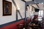
Pub interior. Is that Robin on the wall? / Pub website.


