
Robin Hood (Clifton Reynes): Difference between revisions
m (Text replacement - "|width=34%}}<div class="pnMapLegend">" to "|width=34%|service=leaflet}}<div class="pnMapLegend">") |
m (Text replacement - "|service=leaflet}}" to "|service=leaflet|enablefullscreen=yes}}") |
||
| Line 1: | Line 1: | ||
__NOTOC__{{PnItemTop|Lat=52.152214|Lon=-0.681992|AdmDiv=Buckinghamshire|Vicinity=In Clifton Reynes|Type=Public house|Interest=Robin Hood name|Status=Extant|Demonym=|Riding=|GreaterLondon=|Year=1839|Aka=Robin Hood & Little John; Robin Hood Inn|Century=19|Cluster1=Clifton Reynes|Cluster2=|Cluster3=|Image=geograph-728546-by-Allan-Friswell.jpg|Postcards=|ExtraCat1=Places named after Little John|ExtraCat2=|ExtraCat3=|ExtraCat4=|ExtraCat5=|ExtraLink1=|ExtraLink2=|ExtraLink3=|ExtraLink4=|ExtraLink5=|ExtraLinkName1=|ExtraLinkName2=|ExtraLinkName3=|ExtraLinkName4=|ExtraLinkName5=|GeopointPrefix=|GeopointSuffix=|StatusSuffix=|DatePrefix=|DateSuffix=}} | __NOTOC__{{PnItemTop|Lat=52.152214|Lon=-0.681992|AdmDiv=Buckinghamshire|Vicinity=In Clifton Reynes|Type=Public house|Interest=Robin Hood name|Status=Extant|Demonym=|Riding=|GreaterLondon=|Year=1839|Aka=Robin Hood & Little John; Robin Hood Inn|Century=19|Cluster1=Clifton Reynes|Cluster2=|Cluster3=|Image=geograph-728546-by-Allan-Friswell.jpg|Postcards=|ExtraCat1=Places named after Little John|ExtraCat2=|ExtraCat3=|ExtraCat4=|ExtraCat5=|ExtraLink1=|ExtraLink2=|ExtraLink3=|ExtraLink4=|ExtraLink5=|ExtraLinkName1=|ExtraLinkName2=|ExtraLinkName3=|ExtraLinkName4=|ExtraLinkName5=|GeopointPrefix=|GeopointSuffix=|StatusSuffix=|DatePrefix=|DateSuffix=}} | ||
{{#display_map:52.152214,-0.681992|width=34%|service=leaflet}}<div class="pnMapLegend">The Robin Hood.</div> | {{#display_map:52.152214,-0.681992|width=34%|service=leaflet|enablefullscreen=yes}}<div class="pnMapLegend">The Robin Hood.</div> | ||
[[File:{{#var:Pnimage}}|thumb|right|500px|Robin Hood, Clifton Reynes / [http://www.geograph.org.uk/photo/728546 Allan Friswell, 2003, Creative Commons via Geograph.]]] | [[File:{{#var:Pnimage}}|thumb|right|500px|Robin Hood, Clifton Reynes / [http://www.geograph.org.uk/photo/728546 Allan Friswell, 2003, Creative Commons via Geograph.]]] | ||
<p id="byline">By Henrik Thiil Nielsen, 2013-08-07. Revised by {{#realname:{{REVISIONUSER}}}}, {{REVISIONYEAR}}-{{REVISIONMONTH}}-{{REVISIONDAY2}}.</p> | <p id="byline">By Henrik Thiil Nielsen, 2013-08-07. Revised by {{#realname:{{REVISIONUSER}}}}, {{REVISIONYEAR}}-{{REVISIONMONTH}}-{{REVISIONDAY2}}.</p> | ||
Revision as of 20:02, 5 April 2019
[[File:|thumb|right|500px|Robin Hood, Clifton Reynes / Allan Friswell, 2003, Creative Commons via Geograph.]]
By Henrik Thiil Nielsen, 2013-08-07. Revised by Henrik Thiil Nielsen, 2019-04-05.
The Robin Hood is a public house in Clifton Reynes. The pub dates all the way back to 1577, but it traded under the name of Carpenters Arms until at least as late as 1830. However, by 1839 it had become the Robin Hood, sometimes the Robin Hood & Little John. The excellent UK Pub History site lists information on publicans etc. for the years 1839 to 1935.[1] To this we can add Slater's Directory for 1850 in which the pub is listed as Robin Hood and Little John, the publican a Thomas Hobbs.[2] The earliest map reference known to IRHB is the 25" O.S. map of the area published in 1882 (see Maps section below).
As the village of Clifton Reynes is at the end of a cul-de-sac, the pub has sent its sign a good 350 metres east to an intersection where more travellers are likely to see it.Template:PnItemQry
Gazetteers
- Not included in Dobson, R. B., ed.; Taylor, J., ed. Rymes of Robyn Hood: an Introduction to the English Outlaw (London, 1976), pp. 293-311.
Sources
- Slater, Isaac, compil. Slater's (Late Pigot & Co.) Royal National and Commercial Directory and Topography of the Counties of Bedfordshire, Buckinghamshire, Cambridgeshire, Huntingdonshire, Norfolk, Oxfordshire, and Suffolk (Manchester and London, 1850), p. 29 of the Buckinghamshire section
- UK Pub History: Robin Hood, Church Road, Clifton Reynes, Olney, Buckinghamshire.
Maps
- 25" O.S. map Buckinghamshire V.3 (1882; surveyed 1881)
- 25" O.S. map Buckinghamshire V.3 (1900; rev. 1899) (georeferenced)
- 25" O.S. map Buckinghamshire V.3 (1900; rev. 1899)
- 25" O.S. map Buckinghamshire V.3 (1925; rev. 1924)
- 6" O.S. map Buckinghamshire V (1885; surveyed 1881)
- 6" O.S. map Buckinghamshire V.NE (1900; rev. 1899)
- 6" O.S. map Buckinghamshire V.NE (1900; rev. 1899) (georeferenced)
- 6" O.S. map Buckinghamshire V.NE (1926; rev. 1924)
- 6" O.S. map Buckinghamshire V.NE (1952; rev. 1950).
Notes
- ↑ UK Pub History: Robin Hood, Church Road, Clifton Reynes, Olney, Buckinghamshire. As of 20 Oct. 2018, one entry cites the date "19 August 1958" and the year 1958 but appears among 19th cent. entries, suggesting the proper date year be 1858.
- ↑ Slater, Isaac, compil. Slater's (Late Pigot & Co.) Royal National and Commercial Directory and Topography of the Counties of Bedfordshire, Buckinghamshire, Cambridgeshire, Huntingdonshire, Norfolk, Oxfordshire, and Suffolk (Manchester and London, 1850), p. 29 of the Buckinghamshire section.
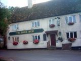
Robin Hood, Clifton Reynes / Allan Friswell, 2003, Creative Commons via Geograph.

The Robin Hood. The village pub / Cameraman, 20 May 2010, Creative Commons via Geograph.
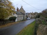
Clifton Reynes. The Robin Hood is the village pub shown on the left / Nigel Stickells, 14 Nov. 2006, Creative Commons via Geograph.


