
Robin Hood (Chiswick)
From International Robin Hood Bibliography
| Locality | |
|---|---|
| Coordinate | 51.492921, -0.267493 |
| Adm. div. | Middlesex, now Greater London |
| Vicinity | 450 Chiswick High Road, Chiswick, London |
| Type | Public house |
| Interest | Robin Hood name |
| Status | Extant |
| First Record | 1871 |
| A.k.a. | Robin Hood & Little John; Connolly's Bar |
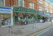
The former Robin Hood.

The former Robin Hood / Anthony O'Neil, 09 July 2019; Creative Commons, via Geograph.
By Henrik Thiil Nielsen, 2020-11-23. Revised by Henrik Thiil Nielsen, 2021-01-06.
The Robin Hood or Robin Hood & Little John at 450 Chiswick High Road, Chiswick, London, formerly Middlesex, was in existence by 1871. In 2014 it became Connolly's Bar.[1]
A list of publicans etc. for the years 1871–1944 can be found at the Pub Wiki.[2]
Gazetteers
- Not included in Dobson, R. B., ed.; Taylor, J., ed. Rymes of Robyn Hood: an Introduction to the English Outlaw (London, 1976), pp. 293-311.
Sources
Maps
- 25" O.S. map Middlesex XXI.1 (c. 1866; surveyed 1865). No Copy in NLS
- 25" O.S. map London (Edition of 1894-96) LXXXIV (1897; rev. 1891) (georeferenced)
- 25" O.S. map London (1897; rev. 1891–94)
- 25" O.S. map Middlesex XXI.1 (1915; rev. 1912–13)
- 6" O.S. map Surrey II.SW (1898; rev. 1891–94) (georeferenced)
- 6" O.S. map Middlesex XXI (1873; surveyed 1865–66)
- 6" O.S. map London X.NW (1894–96; rev. 1891
- 6" O.S. map Surrey II.SW (1898; rev. 1891–94)
- 6" O.S. map Surrey II.SW (1920; rev. 1910)
- 6" O.S. map London Sheet N (1920; rev. 1912–13)
- 6" O.S. map Surrey II.SW (1936; rev. 1933)
- 6" O.S. map Surrey II.SW (c. 1944; rev. 1933)
- 6" O.S. map London Sheet N (c. 1946; rev. 1938).
Background
Also see
Notes
The former Robin Hood / Anthony O'Neil, 09 July 2019; Creative Commons, via Geograph.
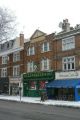
Connolly's Bar, formerly the Robin Hood / Alan Murray-Rust, 19 Dec. 2010; Creative Commons, via Geograph.
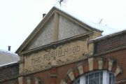
The Robin Hood: a relic of an earlier name for what is now called Connolly's / Alan Murray-Rust, 19 Dec. 2010; Creative Commons, via Geograph.

