
Robin Hood (Chiswick): Difference between revisions
m (Text replacement - "ImgGalleryIntro" to "ImageGalleryIntroduction") |
m (Text replacement - "the Pub Wiki" to "Pub History") |
||
| (One intermediate revision by the same user not shown) | |||
| Line 6: | Line 6: | ||
The Robin Hood or Robin Hood & Little John at 450 Chiswick High Road, Chiswick, London, formerly Middlesex, was in existence by 1871. In 2014 it became Connolly's Bar.<ref>[http://www.connollysbarchiswick.co.uk Connolly's Chiswick;] [https://www.facebook.com/connollyschiswick Facebook: Connolly's Chiswick.]</ref> | The Robin Hood or Robin Hood & Little John at 450 Chiswick High Road, Chiswick, London, formerly Middlesex, was in existence by 1871. In 2014 it became Connolly's Bar.<ref>[http://www.connollysbarchiswick.co.uk Connolly's Chiswick;] [https://www.facebook.com/connollyschiswick Facebook: Connolly's Chiswick.]</ref> | ||
A list of publicans etc. for the years 1871–1944 can be found at | A list of publicans etc. for the years 1871–1944 can be found at Pub History.<ref>[https://pubwiki.co.uk/Middlesex/Chiswick/RobinHood.shtml Pub Wiki: Robin Hood, 450 Chiswick High Road, Chiswick W4.]</ref> | ||
{{PlaceNamesItemAllusionsAndRecords}} | {{PlaceNamesItemAllusionsAndRecords}} | ||
== Gazetteers == | == Gazetteers == | ||
| Line 14: | Line 14: | ||
== Maps == | == Maps == | ||
* 25" O.S. map ''Middlesex'' XXI.1 (''c.'' 1866; surveyed 1865). No | * 25" O.S. map ''Middlesex'' XXI.1 (''c.'' 1866; surveyed 1865). No copy in NLS | ||
* [https://maps.nls.uk/geo/explore/#zoom=18&lat=51.49290&lon=-0.26842&layers=168&b=5 25" O.S. map ''London'' (Edition of 1894-96) LXXXIV (1897; rev. 1891)] (georeferenced) | * [https://maps.nls.uk/geo/explore/#zoom=18&lat=51.49290&lon=-0.26842&layers=168&b=5 25" O.S. map ''London'' (Edition of 1894-96) LXXXIV (1897; rev. 1891)] (georeferenced) | ||
* [https://maps.nls.uk/view/101919846#zoom=6&lat=10906&lon=14887&layers=BT 25" O.S. map ''London'' (1897; rev. 1891–94)] | * [https://maps.nls.uk/view/101919846#zoom=6&lat=10906&lon=14887&layers=BT 25" O.S. map ''London'' (1897; rev. 1891–94)] | ||
Latest revision as of 16:31, 3 May 2022
| Locality | |
|---|---|
| Coordinate | 51.492921, -0.267493 |
| Adm. div. | Middlesex, now Greater London |
| Vicinity | 450 Chiswick High Road, Chiswick, London |
| Type | Public house |
| Interest | Robin Hood name |
| Status | Extant |
| First Record | 1871 |
| A.k.a. | Robin Hood & Little John; Connolly's Bar |

By Henrik Thiil Nielsen, 2020-11-23. Revised by Henrik Thiil Nielsen, 2022-05-03.
The Robin Hood or Robin Hood & Little John at 450 Chiswick High Road, Chiswick, London, formerly Middlesex, was in existence by 1871. In 2014 it became Connolly's Bar.[1]
A list of publicans etc. for the years 1871–1944 can be found at Pub History.[2]
Gazetteers
- Not included in Dobson, R. B., ed.; Taylor, J., ed. Rymes of Robyn Hood: an Introduction to the English Outlaw (London, 1976), pp. 293-311.
Sources
Maps
- 25" O.S. map Middlesex XXI.1 (c. 1866; surveyed 1865). No copy in NLS
- 25" O.S. map London (Edition of 1894-96) LXXXIV (1897; rev. 1891) (georeferenced)
- 25" O.S. map London (1897; rev. 1891–94)
- 25" O.S. map Middlesex XXI.1 (1915; rev. 1912–13)
- 6" O.S. map Surrey II.SW (1898; rev. 1891–94) (georeferenced)
- 6" O.S. map Middlesex XXI (1873; surveyed 1865–66)
- 6" O.S. map London X.NW (1894–96; rev. 1891
- 6" O.S. map Surrey II.SW (1898; rev. 1891–94)
- 6" O.S. map Surrey II.SW (1920; rev. 1910)
- 6" O.S. map London Sheet N (1920; rev. 1912–13)
- 6" O.S. map Surrey II.SW (1936; rev. 1933)
- 6" O.S. map Surrey II.SW (c. 1944; rev. 1933)
- 6" O.S. map London Sheet N (c. 1946; rev. 1938).
Background
Also see
Notes
Image gallery
Click any image to display it in the lightbox, where you can navigate between images by clicking in the right or left side of the current image.
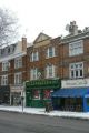
The former Robin Hood / Anthony O'Neil, 09 July 2019; Creative Commons, via Geograph.
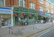
Connolly's Bar, formerly the Robin Hood / Alan Murray-Rust, 19 Dec. 2010; Creative Commons, via Geograph.
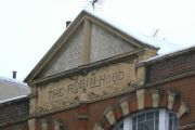
The Robin Hood: a relic of an earlier name for what is now called Connolly's / Alan Murray-Rust, 19 Dec. 2010; Creative Commons, via Geograph.

