
Robin Hood (Boston): Difference between revisions
mNo edit summary |
m (Text replacement - "UK Pub History" to "Pub History") |
||
| (22 intermediate revisions by 2 users not shown) | |||
| Line 1: | Line 1: | ||
__NOTOC__{{ | __NOTOC__{{PlaceNamesItemTop|Lat=52.973264|Lon=-0.024763|AdministrativeDivision=Lincolnshire|Vicinity=104 High Street, Boston|Type=Public house|Interest=Robin Hood name|Status=Extant|Demonym=|Riding=|GreaterLondon=|Year=1861|Aka=|Century=|Cluster1=|Cluster2=Boston|Cluster3=|Image=geograph-3675752-by-Dave-Hitchborne.jpg|Postcards=|ExtraCat1=|ExtraCat2=|ExtraCat3=|ExtraCat4=|ExtraCat5=|ExtraLink1=|ExtraLink2=|ExtraLink3=|ExtraLink4=|ExtraLink5=|ExtraLinkName1=|ExtraLinkName2=|ExtraLinkName3=|ExtraLinkName4=|ExtraLinkName5=|GeopointPrefix=|GeopointSuffix=|StatusSuffix=|DatePrefix=|DateSuffix=}} | ||
{{#display_map:{{#var:Coords}}~{{#replace:{{PAGENAME}}|'|'}}|width=34%}}<div class="pnMapLegend">The Robin Hood.</div> | {{#display_map:{{#var:Coords}}~{{#replace:{{PAGENAME}}|'|'}}|width=34%|enablefullscreen=yes}}<div class="pnMapLegend">The Robin Hood.</div> | ||
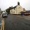
[[File:{{#var: | [[File:{{#var:Image}}|thumb|right|350px|The Robin Hood, High Street, Boston / [http://www.geograph.org.uk/photo/3675662 Dave Hitchborne, 25 Sep. 2013, Creative Commons, via Geograph.]]]<div class="no-img"> | ||
<p id="byline">By Henrik Thiil Nielsen, 2013-08-07. Revised by {{#realname:{{REVISIONUSER}}}}, {{REVISIONYEAR}}-{{REVISIONMONTH}}-{{REVISIONDAY2}}.</p> | <p id="byline">By Henrik Thiil Nielsen, 2013-08-07. Revised by {{#realname:{{REVISIONUSER}}}}, {{REVISIONYEAR}}-{{REVISIONMONTH}}-{{REVISIONDAY2}}.</p> | ||
The Robin Hood on High Street in Boston, Lincolnshire, was in existence by 1861. It evidently underwent a change of name in the not too distant past and for a while traded as "PJ's Pie Pub", but by 25 Sep. 2013 it had again become the Robin Hood.<ref>[http://www.geograph.org.uk/photo/3675752 Geograph: High Street, Boston;] by Dave Hitchborne.</ref> Information on publicans for the years 1861 to 1905 can be found at Pub History.<ref>[https://pubhistory.co.uk//Lincolnshire/Boston/RobinHood.shtml Pub History: Robin Hood, 104 High street, Boston, Lincolnshire.]</ref>{{PlaceNamesItemAllusionsAndRecords}} | |||
The Robin Hood on High Street in Boston, Lincolnshire, was in existence by 1861. It evidently underwent a change of name in the not too distant past and for a while traded as "PJ's Pie Pub", but by 25 Sep. 2013 it had again become the Robin Hood.<ref>[http://www.geograph.org.uk/photo/3675752 Geograph: High Street, Boston;] by Dave Hitchborne.</ref> Information on publicans for the years 1861 to 1905 can be found at | |||
== Gazetteers == | == Gazetteers == | ||
| Line 11: | Line 10: | ||
== Sources == | == Sources == | ||
* [http://www.geograph.org.uk/photo/3675752 Geograph: High Street, Boston;] by Dave Hitchborne | * [http://www.geograph.org.uk/photo/3675752 Geograph: High Street, Boston;] by Dave Hitchborne | ||
* [https://pubhistory.co.uk//Lincolnshire/Boston/RobinHood.shtml | * [https://pubhistory.co.uk//Lincolnshire/Boston/RobinHood.shtml Pub History: Robin Hood, 104 High street, Boston, Lincolnshire.] | ||
== Maps == | |||
* [https://maps.nls.uk/geo/explore/#zoom=18&lat=52.9733&lon=-0.0247&layers=168&b=5 25" O.S. map ''Lincolnshire'' CIX.13 (1905; rev. 1903)] (georeferenced) | |||
* [https://maps.nls.uk/view/114652182#zoom=5&lat=10795&lon=11130&layers=BT 25" O.S. map ''Lincolnshire'' CIX.13 (1905; rev. 1903)] | |||
* [https://maps.nls.uk/view/114652179#zoom=5&lat=10460&lon=11236&layers=BT 25" O.S. map ''Lincolnshire'' CIX.13 (1889; surveyed 1888)] | |||
* [https://maps.nls.uk/geo/explore/#zoom=17&lat=52.9733&lon=-0.0239&layers=6&b=5 6" O.S. map ''Lincolnshire'' CIX.SW (1906; rev. 1903)] (georeferenced) | |||
* [https://maps.nls.uk/view/101590427#zoom=5&lat=3492&lon=3530&layers=BT 6" O.S. map ''Lincolnshire'' CIX.SW (1906; rev. 1903)] | |||
* [https://maps.nls.uk/view/101590424#zoom=5&lat=3476&lon=3424&layers=BT 6" O.S. map ''Lincolnshire'' CIX.SW (''c.'' 1947; rev. 1938)] | |||
* [https://maps.nls.uk/view/101590421#zoom=5&lat=3627&lon=3618&layers=BT 6" O.S. map ''Lincolnshire'' CIX.SW (1951; rev. 1946).] | |||
{{ | == Background == | ||
* [https://www.facebook.com/robinhood.pizza.oven/ Facebook: The Robin Hood Inn.] | |||
{{PlaceNamesItemAlsoSee}} | |||
== Notes == | == Notes == | ||
<references/> | <references/> | ||
</div> | </div> | ||
{{ | <div id="gallery"> | ||
{{ImageGalleryIntroduction}} | |||
<gallery widths="195px"> | <gallery widths="195px"> | ||
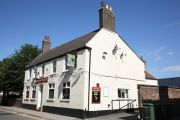
geograph-3675662-by-Dave-Hitchborne.jpg|The Robin Hood, High Street, Boston / [http://www.geograph.org.uk/photo/3675662 Dave Hitchborne, 25 Sep. 2013, Creative Commons via Geograph.] | geograph-3675662-by-Dave-Hitchborne.jpg|The Robin Hood, High Street, Boston / [http://www.geograph.org.uk/photo/3675662 Dave Hitchborne, 25 Sep. 2013, Creative Commons, via Geograph.] | ||
geograph-3675752-by-Dave-Hitchborne.jpg|The Robin Hood, High Street, Boston / [http://www.geograph.org.uk/photo/3675752 Dave Hitchborne, 25 Sep. 2013, Creative Commons via Geograph.] | geograph-3675752-by-Dave-Hitchborne.jpg|The Robin Hood, High Street, Boston / [http://www.geograph.org.uk/photo/3675752 Dave Hitchborne, 25 Sep. 2013, Creative Commons, via Geograph.] | ||
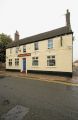
Robin Hood (High Street, Boston, Lincolnshire).jpg|The Robin Hood / [http://www.bateman.co.uk/our+pubs/search+for+a+pub/Robin+Hood Bateman's: Robin Hood.] | Robin Hood (High Street, Boston, Lincolnshire).jpg|The Robin Hood / [http://www.bateman.co.uk/our+pubs/search+for+a+pub/Robin+Hood Bateman's: Robin Hood.] | ||
</gallery> | </gallery> | ||
</div> | |||
{{ | {{PlaceNamesItemNavigation}} | ||
Latest revision as of 15:28, 5 May 2022
| Locality | |
|---|---|
| Coordinate | 52.973264, -0.024763 |
| Adm. div. | Lincolnshire |
| Vicinity | 104 High Street, Boston |
| Type | Public house |
| Interest | Robin Hood name |
| Status | Extant |
| First Record | 1861 |

By Henrik Thiil Nielsen, 2013-08-07. Revised by Henrik Thiil Nielsen, 2022-05-05.
The Robin Hood on High Street in Boston, Lincolnshire, was in existence by 1861. It evidently underwent a change of name in the not too distant past and for a while traded as "PJ's Pie Pub", but by 25 Sep. 2013 it had again become the Robin Hood.[1] Information on publicans for the years 1861 to 1905 can be found at Pub History.[2]
Gazetteers
- Not included in Dobson, R. B., ed.; Taylor, J., ed. Rymes of Robyn Hood: an Introduction to the English Outlaw (London, 1976), pp. 293-311.
Sources
- Geograph: High Street, Boston; by Dave Hitchborne
- Pub History: Robin Hood, 104 High street, Boston, Lincolnshire.
Maps
- 25" O.S. map Lincolnshire CIX.13 (1905; rev. 1903) (georeferenced)
- 25" O.S. map Lincolnshire CIX.13 (1905; rev. 1903)
- 25" O.S. map Lincolnshire CIX.13 (1889; surveyed 1888)
- 6" O.S. map Lincolnshire CIX.SW (1906; rev. 1903) (georeferenced)
- 6" O.S. map Lincolnshire CIX.SW (1906; rev. 1903)
- 6" O.S. map Lincolnshire CIX.SW (c. 1947; rev. 1938)
- 6" O.S. map Lincolnshire CIX.SW (1951; rev. 1946).
Background
Also see
Notes
Image gallery
Click any image to display it in the lightbox, where you can navigate between images by clicking in the right or left side of the current image.
The Robin Hood, High Street, Boston / Dave Hitchborne, 25 Sep. 2013, Creative Commons, via Geograph.
The Robin Hood, High Street, Boston / Dave Hitchborne, 25 Sep. 2013, Creative Commons, via Geograph.
The Robin Hood / Bateman's: Robin Hood.

.jpg)