Robin Hood (Bishop's Stortford): Difference between revisions
From International Robin Hood Bibliography
m (Text replacement - "|service=leaflet}}" to "|service=leaflet|enablefullscreen=yes}}") |
m (Text replacement - "UK Pub History" to "Pub History") |
||
| (18 intermediate revisions by the same user not shown) | |||
| Line 1: | Line 1: | ||
__NOTOC__{{ | __NOTOC__{{PlaceNamesItemTop|Lat=51.872618|Lon=0.156775|AdministrativeDivision=Hertfordshire|Vicinity=24 Hadham Road, Bishop's Stortford|Type=Public house|Interest=Robin Hood name|Status=Defunct|Demonym=|Riding=|GreaterLondon=|Year=1861|Aka=|Century=|Cluster1=|Cluster2=|Cluster3=|Image=geograph-2547116-by-Thomas-Nugent.jpg|Postcards=|ExtraCat1=|ExtraCat2=|ExtraCat3=|ExtraCat4=|ExtraCat5=|ExtraLink1=|ExtraLink2=|ExtraLink3=|ExtraLink4=|ExtraLink5=|ExtraLinkName1=|ExtraLinkName2=|ExtraLinkName3=|ExtraLinkName4=|ExtraLinkName5=|GeopointPrefix=|GeopointSuffix=|StatusSuffix=|DatePrefix=|DateSuffix=}} | ||
{{#display_map:{{#var:Coords}}~{{#replace:{{PAGENAME}}|'|'}}|width=34% | {{#display_map:{{#var:Coords}}~{{#replace:{{PAGENAME}}|'|'}}|width=34%|enablefullscreen=yes}}<div class="pnMapLegend">The Robin Hood.</div> | ||
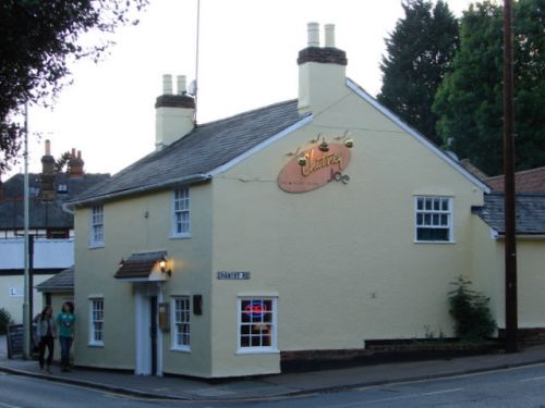
[[File:{{#var: | [[File:{{#var:Image}}|thumb|right|500px|Chutney Joe, Indian style bar/diner, formerly the Robin Hood / [http://www.geograph.org.uk/photo/2547116 Thomas Nugent, 31 May 2011; Creative Commons, via Geograph.]]]<div class="no-img"> | ||
<p id="byline">By Henrik Thiil Nielsen, 2013-08-07. Revised by {{#realname:{{REVISIONUSER}}}}, {{REVISIONYEAR}}-{{REVISIONMONTH}}-{{REVISIONDAY2}}.</p> | <p id="byline">By Henrik Thiil Nielsen, 2013-08-07. Revised by {{#realname:{{REVISIONUSER}}}}, {{REVISIONYEAR}}-{{REVISIONMONTH}}-{{REVISIONDAY2}}.</p> | ||
The Robin Hood on Hadham Road, Bishop's Stortford, is first recorded in 1861. A beer house for many years, it only obtained a full licence in 1955. In 2004 its name was changed to Chutney Joe. It is now a restaurant rather than a pub. | The Robin Hood on Hadham Road, Bishop's Stortford, is first recorded in 1861. A beer house for many years, it only obtained a full licence in 1955. In 2004 its name was changed to Chutney Joe. It is now a restaurant rather than a pub. | ||
In Kelly's ''Directory'' for 1912, the address is cited as 10 Hadham Road. Perhaps house numbering was subsequently changed. A listing of publican for the years 1861 to 1912 can be found at | In Kelly's ''Directory'' for 1912, the address is cited as 10 Hadham Road. Perhaps house numbering was subsequently changed. A listing of publican for the years 1861 to 1912 can be found at Pub History.<ref>[https://pubwiki.co.uk/HertsPubs/BishopsStortford/RobinHood.shtml Pub History: Robin Hood, 24 Hadham Road, Bishops Stortford, Hertfordshire.] Also see [https://pubwiki.co.uk/WatneyTruman1988/WatneyTruman1988-RS.shtml Pub History: Watney Truman Public Houses, London and South East 1988 to 1990 - RS.]</ref> | ||
{{PlaceNamesItemAllusionsAndRecords}} | |||
== Gazetteers == | |||
* Not included in {{:Dobson, Richard Barrie 1976a}}, pp. 293-311. | |||
== Maps == | == Maps == | ||
* 25" O.S. map ''Essex'' XXII.15 (''c.'' 1881; surveyed 1876) | * 25" O.S. map ''Essex'' XXII.15 (''c.'' 1881; surveyed 1876). No copy in NLS | ||
* 25" O.S. map ''Hertfordshire'' XXIII.6 (''c.'' 1879; surveyed 1877-78) | * 25" O.S. map ''Hertfordshire'' XXIII.6 (''c.'' 1879; surveyed 1877-78). No copy in NLS | ||
* [https://maps.nls.uk/view/104188826#zoom=5&lat=7386&lon=6398&layers=BT 25" O.S. map ''Essex (1897; rev. 1896)] | * [https://maps.nls.uk/view/104188826#zoom=5&lat=7386&lon=6398&layers=BT 25" O.S. map ''Essex'' (1897; rev. 1896)] | ||
* [https://maps.nls.uk/geo/explore/#zoom=18&lat=51.8728&lon=0.1557&layers=168&b=5 25" O.S. map ''Hertfordshire'' XXIII.6 (1898; rev. 1896)] (georeferenced) | * [https://maps.nls.uk/geo/explore/#zoom=18&lat=51.8728&lon=0.1557&layers=168&b=5 25" O.S. map ''Hertfordshire'' XXIII.6 (1898; rev. 1896)] (georeferenced) | ||
* [https://maps.nls.uk/view/104200330#zoom=5&lat=3291&lon=1762&layers=BT 25" O.S. map ''Hertfordshire'' XXIII.6 (1898; rev. 1896)] | * [https://maps.nls.uk/view/104200330#zoom=5&lat=3291&lon=1762&layers=BT 25" O.S. map ''Hertfordshire'' XXIII.6 (1898; rev. 1896)] | ||
* [https://maps.nls.uk/view/104192145#zoom=5&lat=3202&lon=1674&layers=BT 25" O.S. map ''Essex (1921; rev. 1916)] | * [https://maps.nls.uk/view/104192145#zoom=5&lat=3202&lon=1674&layers=BT 25" O.S. map ''Essex'' (1921; rev. 1916)] | ||
* [https://maps.nls.uk/view/104192142#zoom=5&lat=3457&lon=1924&layers=BT 25" O.S. map ''Essex (1947; rev. 1939)] | * [https://maps.nls.uk/view/104192142#zoom=5&lat=3457&lon=1924&layers=BT 25" O.S. map ''Essex'' (1947; rev. 1939)] | ||
* [https://maps.nls.uk/view/102343310#zoom=6&lat=6267&lon=5161&layers=BT 6" O.S. map ''Hertfordshire'' XXIII (1880-83; surveyed 1874-79)] | * [https://maps.nls.uk/view/102343310#zoom=6&lat=6267&lon=5161&layers=BT 6" O.S. map ''Hertfordshire'' XXIII (1880-83; surveyed 1874-79)] | ||
* [https://maps.nls.uk/geo/explore/#zoom=17&lat=51.8729&lon=0.1560&layers=6&b=5 6" O.S. map ''Essex'' XXII.SE (1898; rev. 1896)] (georeferenced) | * [https://maps.nls.uk/geo/explore/#zoom=17&lat=51.8729&lon=0.1560&layers=6&b=5 6" O.S. map ''Essex'' XXII.SE (1898; rev. 1896)] (georeferenced) | ||
| Line 25: | Line 27: | ||
== Sources == | == Sources == | ||
* [https:// | * [https://pubwiki.co.uk/HertsPubs/BishopsStortford/RobinHood.shtml Pub History: Robin Hood, 24 Hadham Road, Bishops Stortford, Hertfordshire.]<ref>Also see [https://pubwiki.co.uk/WatneyTruman1988/WatneyTruman1988-RS.shtml Pub History: Watney Truman Public Houses, London and South East 1988 to 1990 - RS.]</ref> | ||
== Notes == | == Notes == | ||
| Line 33: | Line 34: | ||
</div> | </div> | ||
{{ | {{PlaceNamesItemNavigation}} | ||
Latest revision as of 15:27, 5 May 2022
| Locality | |
|---|---|
| Coordinate | 51.872618, 0.156775 |
| Adm. div. | Hertfordshire |
| Vicinity | 24 Hadham Road, Bishop's Stortford |
| Type | Public house |
| Interest | Robin Hood name |
| Status | Defunct |
| First Record | 1861 |
The Robin Hood.

Chutney Joe, Indian style bar/diner, formerly the Robin Hood / Thomas Nugent, 31 May 2011; Creative Commons, via Geograph.
By Henrik Thiil Nielsen, 2013-08-07. Revised by Henrik Thiil Nielsen, 2022-05-05.
The Robin Hood on Hadham Road, Bishop's Stortford, is first recorded in 1861. A beer house for many years, it only obtained a full licence in 1955. In 2004 its name was changed to Chutney Joe. It is now a restaurant rather than a pub.
In Kelly's Directory for 1912, the address is cited as 10 Hadham Road. Perhaps house numbering was subsequently changed. A listing of publican for the years 1861 to 1912 can be found at Pub History.[1]
Gazetteers
- Not included in Dobson, R. B., ed.; Taylor, J., ed. Rymes of Robyn Hood: an Introduction to the English Outlaw (London, 1976), pp. 293-311.
Maps
- 25" O.S. map Essex XXII.15 (c. 1881; surveyed 1876). No copy in NLS
- 25" O.S. map Hertfordshire XXIII.6 (c. 1879; surveyed 1877-78). No copy in NLS
- 25" O.S. map Essex (1897; rev. 1896)
- 25" O.S. map Hertfordshire XXIII.6 (1898; rev. 1896) (georeferenced)
- 25" O.S. map Hertfordshire XXIII.6 (1898; rev. 1896)
- 25" O.S. map Essex (1921; rev. 1916)
- 25" O.S. map Essex (1947; rev. 1939)
- 6" O.S. map Hertfordshire XXIII (1880-83; surveyed 1874-79)
- 6" O.S. map Essex XXII.SE (1898; rev. 1896) (georeferenced)
- 6" O.S. map Essex XXII.SE (1898; rev. 1896)
- 6" O.S. map Essex nXXXII (1923; rev. 1915-16)
- 6" O.S. map Essex nXXXII.NW (1923; rev. 1916)
- 6" O.S. map Essex nXXXII.NW (c. 1946; rev. 1938)
- 6" O.S. map Essex nXXXII.NW (1950; rev. 1946).
Sources
Notes
