Robin Hood's Well (Penhill, Wensleydale): Difference between revisions
From International Robin Hood Bibliography
m (Text replacement - "=== Allusions ===" to "== Allusions ==") |
m (Text replacement - "embedformat=h4" to "embedformat=h3") |
||
| Line 6: | Line 6: | ||
A Robin Hood's Well high on the east side of Penhill in Wensleydale is included on the 6" O.S. map of the area published in 1856.<ref> [http://maps.nls.uk/view/102344383#zoom=6&lat=990&lon=12630&layers=BT 6" O.S. map ''Yorkshire'' 67 (1856; surveyed 1854)]</ref> The well is a "natural spring [which] emerges from the hillside running over a few small stones at first but then making its way beneath a slab of rock and plunging down the slopes between rough grass and bracken. Just above the well and overshadowing it is a healthy hawthorn tree, the only surviving one on this exposed shoulder of the hill."<ref>[http://people.bath.ac.uk/liskmj/living-spring/sourcearchive/fs6/fs6ew1.htm Holy Wells in Yorkshire - 4] by Edna Whelan.</ref> Dobson & Taylor note it as "[a] well at the source of a hill stream on Melmerby Moor south of Wensleydale".<ref>{{:Dobson, Richard Barrie 1976a}}, p. 307, ''s.n.'' Robin Hood's Well.</ref> | A Robin Hood's Well high on the east side of Penhill in Wensleydale is included on the 6" O.S. map of the area published in 1856.<ref> [http://maps.nls.uk/view/102344383#zoom=6&lat=990&lon=12630&layers=BT 6" O.S. map ''Yorkshire'' 67 (1856; surveyed 1854)]</ref> The well is a "natural spring [which] emerges from the hillside running over a few small stones at first but then making its way beneath a slab of rock and plunging down the slopes between rough grass and bracken. Just above the well and overshadowing it is a healthy hawthorn tree, the only surviving one on this exposed shoulder of the hill."<ref>[http://people.bath.ac.uk/liskmj/living-spring/sourcearchive/fs6/fs6ew1.htm Holy Wells in Yorkshire - 4] by Edna Whelan.</ref> Dobson & Taylor note it as "[a] well at the source of a hill stream on Melmerby Moor south of Wensleydale".<ref>{{:Dobson, Richard Barrie 1976a}}, p. 307, ''s.n.'' Robin Hood's Well.</ref> | ||
<!--== Allusions == | <!--== Allusions == | ||
{{#ask:[[Category:Allusions (Robin Hood's Well, Penhill, Wensleydale)]]|format=embedded|embedformat= | {{#ask:[[Category:Allusions (Robin Hood's Well, Penhill, Wensleydale)]]|format=embedded|embedformat=h3|columns=1|limit=1000|sort=Utitle}}--> | ||
== Gazetteers == | == Gazetteers == | ||
Revision as of 15:46, 12 July 2018
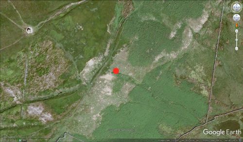
Robin Hood's Well on Penhill. The marker indicates the source of the well.
By Henrik Thiil Nielsen, 2017-01-11. Revised by Henrik Thiil Nielsen, 2018-07-12.
A Robin Hood's Well high on the east side of Penhill in Wensleydale is included on the 6" O.S. map of the area published in 1856.[1] The well is a "natural spring [which] emerges from the hillside running over a few small stones at first but then making its way beneath a slab of rock and plunging down the slopes between rough grass and bracken. Just above the well and overshadowing it is a healthy hawthorn tree, the only surviving one on this exposed shoulder of the hill."[2] Dobson & Taylor note it as "[a] well at the source of a hill stream on Melmerby Moor south of Wensleydale".[3]
Gazetteers
- Dobson, R. B., ed.; Taylor, J., ed. Rymes of Robyn Hood: an Introduction to the English Outlaw (London, 1976), p. 307, s.n. Robin Hood's Well
- Northern Antiquarian: Holy Wells, Healing Springs & Spas.
Sources
- Holy Wells in Yorkshire - 4 by Edna Whelan.
Maps
- 6" O.S. map Yorkshire 67 (1856; surveyed 1854)
- 6" O.S. map Yorkshire 67 (1895; rev. 1891)
- 6" O.S. map Yorkshire LXVII.SE (1914; rev. 1910).
Background
Notes
- ↑ 6" O.S. map Yorkshire 67 (1856; surveyed 1854)
- ↑ Holy Wells in Yorkshire - 4 by Edna Whelan.
- ↑ Dobson, R. B., ed.; Taylor, J., ed. Rymes of Robyn Hood: an Introduction to the English Outlaw (London, 1976), p. 307, s.n. Robin Hood's Well.

