Robin Hood's Well (Penhill, Wensleydale)
From International Robin Hood Bibliography
| Locality | |
|---|---|
| Coordinate | 54.275278, -1.914444 |
| Adm. div. | North Riding of Yorkshire |
| Vicinity | c. 100 m SE of beacon on east side of Penhill |
| Type | Natural feature |
| Interest | Robin Hood name |
| Status | Extant |
| First Record | 1856 |
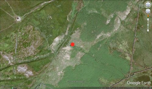
Robin Hood's Well on Penhill. The marker indicates the source of the well.
By Henrik Thiil Nielsen, 2017-01-11. Revised by Henrik Thiil Nielsen, 2021-01-06.
A Robin Hood's Well high on the east side of Penhill in Wensleydale is included on the 6" O.S. map of the area published in 1856.[1] The well is a "natural spring [which] emerges from the hillside running over a few small stones at first but then making its way beneath a slab of rock and plunging down the slopes between rough grass and bracken. Just above the well and overshadowing it is a healthy hawthorn tree, the only surviving one on this exposed shoulder of the hill."[2] Dobson & Taylor note it as "[a] well at the source of a hill stream on Melmerby Moor south of Wensleydale".[3]
Gazetteers
- Dobson, R. B., ed.; Taylor, J., ed. Rymes of Robyn Hood: an Introduction to the English Outlaw (London, 1976), p. 307, s.n. Robin Hood's Well
- Northern Antiquarian: Holy Wells, Healing Springs & Spas.
Sources
- Holy Wells in Yorkshire - 4 by Edna Whelan.
Maps
- 6" O.S. map Yorkshire 67 (1856; surveyed 1854)
- 6" O.S. map Yorkshire 67 (1895; rev. 1891)
- 6" O.S. map Yorkshire LXVII.SE (1914; rev. 1910).
Background
Also see
Notes
- ↑ 6" O.S. map Yorkshire 67 (1856; surveyed 1854)
- ↑ Holy Wells in Yorkshire - 4 by Edna Whelan.
- ↑ Dobson, R. B., ed.; Taylor, J., ed. Rymes of Robyn Hood: an Introduction to the English Outlaw (London, 1976), p. 307, s.n. Robin Hood's Well.

