
Robin Hood's Well (Higham)
| Locality | |
|---|---|
| Coordinate | 53.81239, -2.27858 |
| Adm. div. | Lancashire |
| Vicinity | c. 20 m NW of the Calder, near Higham/Ightenhill Bridge; SE of Pendle Hall Farm |
| Type | Natural feature |
| Interest | Robin Hood name |
| Status | Defunct |
| First Record | 1926 |

By Henrik Thiil Nielsen, 2019-02-23. Revised by Henrik Thiil Nielsen, 2021-01-06.
There was formerly a Robin Hood's Well a few meters north of the Calder, just south of the present Pendle Hall Farm.
The well is mentioned twice in a local ramblers' guide published in 1926 (see Allusions below). There is still a spring there, but its water no longer flows to the surface as the water is being pumped to some nearby locality, perhaps for use at Pendle Hall Farm or as water supply for sheep. A mere trickle flows from the area near the pump to the river. The well water was believed to be efficatious against certain ailments of the eye.[1] An unnamed well is indicated in some of the O.S. maps listed below. Template:PlaceNamesItemQuery
Gazetteers
- Not included in Dobson, R. B., ed.; Taylor, J., ed. Rymes of Robyn Hood: an Introduction to the English Outlaw (London, 1976), pp. 293-311.
Sources
Maps
- 25" O.S. map Lancashire LVI.13 (1893; surveyed 1890-91)
- 25" O.S. map Lancashire LVI.13 (1912; rev. 1910) (georeferenced)
- 25" O.S. map Lancashire LVI.13 (1912; rev. 1910)
- 25" O.S. map Lancashire LVI.13 (1932; rev. 1930)
- 6" O.S. map Lancashire LVI (1848; surveyed 1844)
- 6" O.S. map Lancashire LVI.SW (1895; surveyed 1890-91)
- 6" O.S. map Lancashire LVI.SW (1914; rev. 1909-10) (georeferenced)
- 6" O.S. map Lancashire LVI.SW (1914; rev. 1909-10)
- 6" O.S. map Lancashire LVI.SW (1933; rev. 1929)
- 6" O.S. map Lancashire LVI.SW (1947; rev. 1938).
Brief mention
Notes
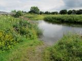
Ford over the River Calder, near the Higham/Ightenhill Bridge and the site of Robin Hood's Well / Chris Heaton, 20 Jul. 2014, Creative Commons, via Geograph.
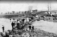
Stepping stones on River Calder, near the site of Robin Hood's Well / Google Maps
