
Robin Hood's Stride (Harthill): Difference between revisions
mNo edit summary |
mNo edit summary |
||
| Line 18: | Line 18: | ||
=== Maps === | === Maps === | ||
* [http://maps.nls.uk/view/101600823#zoom=5&lat=4407&lon=4993&layers=BT 6" O.S. map ''Derbyshire'' XXVIII.SE (1884; surveyed 1877-78)] | * [http://maps.nls.uk/view/101600823#zoom=5&lat=4407&lon=4993&layers=BT 6" O.S. map ''Derbyshire'' XXVIII.SE (1884; surveyed 1877-78)] | ||
* [http://maps.nls.uk/view/101167655#zoom=6&lat=4683&lon=10720&layers=BT 1" O.S. map Sheet 111 (Hills) (1897) | * [http://maps.nls.uk/view/101167655#zoom=6&lat=4683&lon=10720&layers=BT 1" O.S. map Sheet 111 (Hills) (1897)] | ||
* [http://maps.nls.uk/view/101167658#zoom=6&lat=4610&lon=11618&layers=BT 1" O.S. map Sheet 111 (Outline) (1897) | * [http://maps.nls.uk/view/101167658#zoom=6&lat=4610&lon=11618&layers=BT 1" O.S. map Sheet 111 (Outline) (1897)] | ||
* [http://maps.nls.uk/view/101600820#zoom=5&lat=4348&lon=4641&layers=BT 6" O.S. map ''Derbyshire'' XXVIII.SE (1900; rev. 1897)] | * [http://maps.nls.uk/view/101600820#zoom=5&lat=4348&lon=4641&layers=BT 6" O.S. map ''Derbyshire'' XXVIII.SE (1900; rev. 1897)] | ||
* [http://maps.nls.uk/view/102341340#zoom=6&lat=4493&lon=11788&layers=BT 6" O.S. map ''Derbyshire'' XXVIII (1923; rev. 1919-20)] | * [http://maps.nls.uk/view/102341340#zoom=6&lat=4493&lon=11788&layers=BT 6" O.S. map ''Derbyshire'' XXVIII (1923; rev. 1919-20)] | ||
| Line 35: | Line 35: | ||
</div> | </div> | ||
{{ImgGalleryIntro}} | {{ImgGalleryIntro}} | ||
<gallery widths="195px">File: | <gallery widths="195px"> | ||
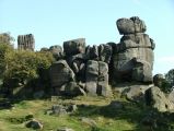
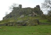
File: | File:Rhs stride j147.jpg|Robin Hood's Stride / [http://www.geograph.org.uk/photo/553120 J147, 11 Sep. 2007, Creative Commons, via Geograph] | ||
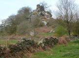
File:Geograph-2359600-by-Andrew-Hill.jpg|Robin Hood's Stride from the southeast / [http://www.geograph.org.uk/photo/2359600 Andrew Hill, 11 Apr. 2011, Creative Commons, via Geograph] | |||
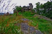
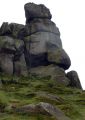
File:Rhs stride tom heyes.jpg|Robin Hood's Stride / [http://www.panoramio.com/user/2623468 Tom Heyes.] | File:Rhs stride tom heyes.jpg|Robin Hood's Stride / [http://www.panoramio.com/user/2623468 Tom Heyes.] | ||
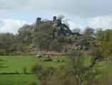
File:Geograph-2360761-by-Andrew-Hill.jpg|Robin Hood's Stride / [http://www.geograph.org.uk/profile/17057 Andrew Hill.] | File:Geograph-2360761-by-Andrew-Hill.jpg|Robin Hood's Stride / [http://www.geograph.org.uk/profile/17057 Andrew Hill.] | ||
Revision as of 01:00, 29 December 2017

By Henrik Thiil Nielsen, 2014-10-14. Revised by Henrik Thiil Nielsen, 2017-12-29.
Robin Hood's Stride is the name of a formation of broken gritstone rocks on Hartle Moor close to the village of Elton. There is a pinnacle at either end of the formation, that to the west being known as the Weasel pinnacle and that to the east as the Inaccessible pinnacle.[1] The formation is said to owe its name to the belief that the distance between the two pinnacles was equal to the length of Robin Hood's step or stride.[2] The alternative name of Mock Beggar's Hall is due to the general resemblance of the entire formation to a hall (manor house) with each pinnacle as a "chimney" at either end of the "building". The name Robin Hood's Stride is first recorded in an 1819 enclosure award.[3] As Kenneth Cameron notes in one of the English Place-Name Society volumes on Derbyshire, this and all other Robin Hood-related place-names in Derbyshire are first recorded at a late date.[4]
Robin Hood's Stride is a popular tourist attraction.
Gazetteers
Sources
- Cameron, Kenneth. The Place-Names of Derbyshire (English Place-Name Society, vols. XXVII-XXIX) (Cambridge, 1959), vol. I, p. 109; pt. III, p. 760.
- Wikipedia: Robin Hood's Stride.
Maps
- 6" O.S. map Derbyshire XXVIII.SE (1884; surveyed 1877-78)
- 1" O.S. map Sheet 111 (Hills) (1897)
- 1" O.S. map Sheet 111 (Outline) (1897)
- 6" O.S. map Derbyshire XXVIII.SE (1900; rev. 1897)
- 6" O.S. map Derbyshire XXVIII (1923; rev. 1919-20)
- 6" O.S. map Derbyshire XXVIII.SE (1923; rev. 1919-20).
Discussion
- Ackerley, Fred G. 'Robin Hood's Stride', Notes & Queries, Series 10, vol. II (1904), p. 246; suggests the hill was used as a fort in prehistoric times, possibly connected with the nearby "Castle Ring" site.
Brief mention
Notes
- ↑ Wikipedia: Robin Hood's Stride.
- ↑ Dobson, R. B., ed.; Taylor, J., ed. Rymes of Robyn Hood: an Introduction to the English Outlaw (London, 1976), p. 297.
- ↑ Cameron, Kenneth. The Place-Names of Derbyshire (English Place-Name Society, vols. XXVII-XXIX) (Cambridge, 1959), vol. I, p. 109.
- ↑ Cameron, Kenneth. The Place-Names of Derbyshire (English Place-Name Society, vols. XXVII-XXIX) (Cambridge, 1959), pt. III (vol. XXIX), p. 760.
Robin Hood's Stride / J147, 11 Sep. 2007, Creative Commons, via Geograph
Robin Hood's Stride from the southeast / Andrew Hill, 11 Apr. 2011, Creative Commons, via Geograph
Robin Hood's Stride / Tom Heyes.
Robin Hood's Stride / Andrew Hill.
Robin Hood's Stride / Andrew Hill.
Robin Hood's Stride / Andrew Hill.

Robin Hood's Stride / J147.
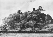
Robin Hood's Stride /Plate from unknown book.
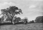
Stone circle near Robin Hood's Stride / Plate from unknown book.
- Robin-hoods-stride-unknown-source.jpg
Robin Hood's Stride / Plate from unknown book.


