
Robin Hood's Stride (Harthill): Difference between revisions
mNo edit summary |
mNo edit summary |
||
| Line 39: | Line 39: | ||
* [http://maps.nls.uk/view/102341340#zoom=6&lat=4493&lon=11788&layers=BT 6" O.S. map ''Derbyshire'' XXVIII (1923; rev. 1919-20)] | * [http://maps.nls.uk/view/102341340#zoom=6&lat=4493&lon=11788&layers=BT 6" O.S. map ''Derbyshire'' XXVIII (1923; rev. 1919-20)] | ||
* [http://maps.nls.uk/view/101600817#zoom=5&lat=4630&lon=4758&layers=BT 6" O.S. map ''Derbyshire'' XXVIII.SE (1923; rev. 1919-20).] | * [http://maps.nls.uk/view/101600817#zoom=5&lat=4630&lon=4758&layers=BT 6" O.S. map ''Derbyshire'' XXVIII.SE (1923; rev. 1919-20).] | ||
=== Discussion === | |||
* {{:Ackerley, Fred G 1904b}}; suggests the hill was used as a fort in prehistoric times, possibly connected with the nearby "Castle Ring" site. | |||
=== Brief mention === | === Brief mention === | ||
* {{:Sandred, Karl Inge 1989a}}, pt. III, p. xvii. | * {{:Sandred, Karl Inge 1989a}}, pt. III, p. xvii. | ||
=== Notes === | === Notes === | ||
<references/> | <references/> | ||
Revision as of 08:51, 23 August 2017
| Locality | |
|---|---|
| Coordinates | 53.156982, -1.666 |
| Adm. div. | Derbyshire |
| Vicinity | 1 km N of Elton |
| Type | Natural feature |
| Interest | Robin Hood name |
| Status | Extant |
| First Record | 1819 |

By Henrik Thiil Nielsen, 2014-10-14. Revised by Henrik Thiil Nielsen, 2017-08-23.
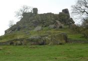
Robin Hood's Stride is the name of a formation of broken gritstone rocks on Hartle Moor close to the village of Elton. There is a pinnacle at either end of the formation, that to the west being known as the Weasel pinnacle and that to the east as the Inaccessible pinnacle.[1] The formation is said to owe its name to the belief that the distance between the two pinnacles was equal to the length of Robin Hood's step or stride.[2] The alternative name of Mock Beggar's Hall is due to the general resemblance of the entire formation to a hall (manor house) with each pinnacle as a "chimney" at either end of the "building". The name Robin Hood's Stride is first recorded in an 1819 enclosure award.[3] As Kenneth Cameron notes in one of the English Place-Name Society volumes on Derbyshire, this and all other Robin Hood-related place-names in Derbyshire are first recorded at a late date.[4]
Robin Hood's Stride is a popular tourist attraction.
Gazetteers
Sources
- Cameron, Kenneth. The Place-Names of Derbyshire (English Place-Name Society, vols. XXVII-XXIX) (Cambridge, 1959), vol. I, p. 109; pt. III, p. 760.
- Wikipedia: Robin Hood's Stride.
Maps
- 6" O.S. map Derbyshire XXVIII.SE (1884; surveyed 1877-78)
- [http://maps.nls.uk/view/101167655#zoom=6&lat=4683&lon=10720&layers=BT 1" O.S. map Sheet 111 (Hills) (1897)
- [http://maps.nls.uk/view/101167658#zoom=6&lat=4610&lon=11618&layers=BT 1" O.S. map Sheet 111 (Outline) (1897)
- 6" O.S. map Derbyshire XXVIII.SE (1900; rev. 1897)
- 6" O.S. map Derbyshire XXVIII (1923; rev. 1919-20)
- 6" O.S. map Derbyshire XXVIII.SE (1923; rev. 1919-20).
Discussion
- Ackerley, Fred G. 'Robin Hood's Stride', Notes & Queries, Series 10, vol. II (1904), p. 246; suggests the hill was used as a fort in prehistoric times, possibly connected with the nearby "Castle Ring" site.
Brief mention
Notes
- ↑ Wikipedia: Robin Hood's Stride.
- ↑ Dobson, R. B., ed.; Taylor, J., ed. Rymes of Robyn Hood: an Introduction to the English Outlaw (London, 1976), p. 297.
- ↑ Cameron, Kenneth. The Place-Names of Derbyshire (English Place-Name Society, vols. XXVII-XXIX) (Cambridge, 1959), vol. I, p. 109.
- ↑ Cameron, Kenneth. The Place-Names of Derbyshire (English Place-Name Society, vols. XXVII-XXIX) (Cambridge, 1959), pt. III (vol. XXIX), p. 760.
Image gallery
Click any image to display it in the lightbox, where you can navigate between images by clicking in the right (or left) side of the current image.
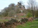
Robin Hood's Stride / Photo: Andrew Hill.

Robin Hood's Stride / Photo: Tom Heyes.

Robin Hood's Stride / Photo: Andrew Hill.
Robin Hood's Stride / Photo: Andrew Hill.
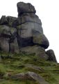
Robin Hood's Stride / Photo: Andrew Hill.

Robin Hood's Stride / Photo: J147.
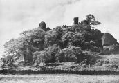
Robin Hood's Stride /Plate from unknown book.
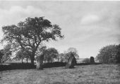
Stone circle near Robin Hood's Stride / Plate from unknown book.
- Robin-hoods-stride-unknown-source.jpg
Robin Hood's Stride / Plate from unknown book.


"th" can not be assigned to a declared number type with value 19.