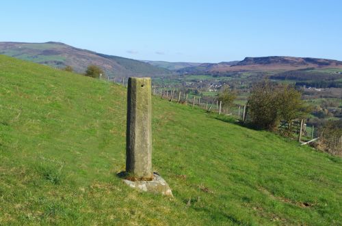
Robin Hood's Stoop (Offerton Moor)
From International Robin Hood Bibliography
Revision as of 01:57, 2 September 2017 by Henryfunk (talk | contribs) (Text replacement - "Category:Derbyshire place-names" to "Category:English place-names Category:Derbyshire place-names")
| Locality | |
|---|---|
| Coordinates | 53.3221, -1.6777 |
| Adm. div. | Derbyshire |
| Vicinity | On E part of Offerton Moor, c. 500 m N of Highlow |
| Type | Monument |
| Interest | Robin Hood name |
| Status | Extant |
| First Record | 1883 |
Robin Hood'S Stoop.

Robin Hood's Stoop (photo by Jim Bell, 16 April 2012).
By Henrik Thiil Nielsen, 2016-09-14. Revised by Henrik Thiil Nielsen, 2017-09-02.
Robin Hood's Stoop on Offerton Moor is an old boundary stone which was perhaps originally part of a medieval wayside cross. According to later tradition Robin Hood shot an arrow from the Stoop all the way to Hathersage churchyard, about 2 km to the NE.[1] Similar traditions relate to Whitby Abbey (North Riding of Yorkshire) and Limlow Hill (Cambridgeshire. The earliest source for this place-name that I know so far is the 6" O.S. map of the area published in 1883, but it seems likely it was included on earlier maps.
Gazetteers
- Dobson, R. B., ed.; Taylor, J., ed. Rymes of Robyn Hood: an Introduction to the English Outlaw (London, 1976), p. 297, s.n. 'Robin Hood's Stoop'.
Sources
- Cameron, Kenneth. The Place-Names of Derbyshire (English Place-Name Society, vols. XXVII-XXIX) (Cambridge, 1959), pt. I, p. 156; and see pt. I, p. lvii.
Maps
- 6" O.S. map Derbyshire X.SE (1883, surveyed 1879-80)
- 1" O.S. map Sheet 99 (Hills) (1896)
- 1" O.S. map Sheet 99 (Outline) (1896)
- 6" O.S. map Derbyshire X.SE (1899, surveyed 1896-97)
- 6" O.S. map Derbyshire X.SE (1923, surveyed 1919)
Also see
Notes
"th" can not be assigned to a declared number type with value 19.
