Robin Hood's Stoop (Offerton Moor): Difference between revisions
mNo edit summary |
mNo edit summary |
||
| Line 6: | Line 6: | ||
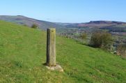
Robin Hood's Stoop on Offerton Moor is an old boundary stone which was perhaps originally part of a medieval wayside cross. According to later tradition Robin Hood shot an arrow from the Stoop all the way to Hathersage churchyard, about 2 km to the NE.<ref>{{:Dobson, Richard Barrie 1976a}}, p. 297, ''s.n.'' 'Robin Hood's Stoop'; {{:Cameron, Kenneth 1959a}}, pt. I, p. 156.</ref> Similar traditions relate to [[Whitby Abbey]] (North Riding of Yorkshire) and [[Limlow Hill (Litlington)|Limlow Hill]] (Cambridgeshire. The earliest source for this place-name I know of so far is the 6" O.S. map of the area published in 1883, but it seems likely it was included on earlier maps. | Robin Hood's Stoop on Offerton Moor is an old boundary stone which was perhaps originally part of a medieval wayside cross. According to later tradition Robin Hood shot an arrow from the Stoop all the way to Hathersage churchyard, about 2 km to the NE.<ref>{{:Dobson, Richard Barrie 1976a}}, p. 297, ''s.n.'' 'Robin Hood's Stoop'; {{:Cameron, Kenneth 1959a}}, pt. I, p. 156.</ref> Similar traditions relate to [[Whitby Abbey]] (North Riding of Yorkshire) and [[Limlow Hill (Litlington)|Limlow Hill]] (Cambridgeshire. The earliest source for this place-name I know of so far is the 6" O.S. map of the area published in 1883, but it seems likely it was included on earlier maps. | ||
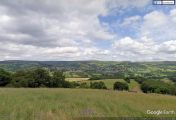
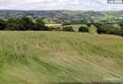
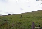
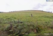
In view of Hathersage's centuries old romance with Little John it is not as surprising as it might otherwise have seemed that Robin Hood's Stoop has an alternative name that connects it with Robin Hood's second in command. The | In view of Hathersage's centuries old romance with Little John it is not as surprising as it might otherwise have seemed that Robin Hood's Stoop has an alternative name that connects it with Robin Hood's second in command. The second image in the gallery below is an early postcard showing "Hathersage From Little John's Flight, Highlow". There is no doubt that the stone seen to the left in the foreground is in fact Robin Hood's Stoop. In the third photo in the gallery, Google gives us a nice view of Hathersage from the unnamed road below the Stoop. A close look tells us it is essentially the same scene as that on the postcard. This becomes still clearer in the next photo from the Google photo car where its camera is pointed a little downwards. As can be seen in the next photo, the Stoop stands not far from the road. In the sixth photo we see the slope from which the postcard photographer took his excellent photo. He was standing somewhat higher up and to the left of the Stoop. Therefore his "Little John's Flight" is Robin Hood's Stoop. I do not believe this alternative name was common. | ||
<!--=== Allusions === | <!--=== Allusions === | ||
{{#ask:[[Category:Allusions (_PLACE-NAME)]]|format=embedded|embedformat=h4|columns=1|limit=1000|sort=Utitle}}--> | {{#ask:[[Category:Allusions (_PLACE-NAME)]]|format=embedded|embedformat=h4|columns=1|limit=1000|sort=Utitle}}--> | ||
| Line 42: | Line 42: | ||
{{ImgGalleryIntro}} | {{ImgGalleryIntro}} | ||
<gallery widths="195px"> | <gallery widths="195px"> | ||
File:Rhs-stoop-explorer-jim.jpg|Robin Hood's Stoop / [http://explorerjims.blogspot.dk/2012/04/robin-hoods-stoop.html Jim Bell, 16 April 2012.] | |||
File:Glen, H G 19xxa-r.jpg|{{:Glen, H G 19xxa}}. | File:Glen, H G 19xxa-r.jpg|{{:Glen, H G 19xxa}}. | ||
File:robin-hoods-stoop-google-earth-street-view-1.jpg| | File:robin-hoods-stoop-google-earth-street-view-1.jpg| | ||
Revision as of 16:03, 31 December 2017

By Henrik Thiil Nielsen, 2016-09-14. Revised by Henrik Thiil Nielsen, 2017-12-31.
Robin Hood's Stoop on Offerton Moor is an old boundary stone which was perhaps originally part of a medieval wayside cross. According to later tradition Robin Hood shot an arrow from the Stoop all the way to Hathersage churchyard, about 2 km to the NE.[1] Similar traditions relate to Whitby Abbey (North Riding of Yorkshire) and Limlow Hill (Cambridgeshire. The earliest source for this place-name I know of so far is the 6" O.S. map of the area published in 1883, but it seems likely it was included on earlier maps.
In view of Hathersage's centuries old romance with Little John it is not as surprising as it might otherwise have seemed that Robin Hood's Stoop has an alternative name that connects it with Robin Hood's second in command. The second image in the gallery below is an early postcard showing "Hathersage From Little John's Flight, Highlow". There is no doubt that the stone seen to the left in the foreground is in fact Robin Hood's Stoop. In the third photo in the gallery, Google gives us a nice view of Hathersage from the unnamed road below the Stoop. A close look tells us it is essentially the same scene as that on the postcard. This becomes still clearer in the next photo from the Google photo car where its camera is pointed a little downwards. As can be seen in the next photo, the Stoop stands not far from the road. In the sixth photo we see the slope from which the postcard photographer took his excellent photo. He was standing somewhat higher up and to the left of the Stoop. Therefore his "Little John's Flight" is Robin Hood's Stoop. I do not believe this alternative name was common.
Gazetteers
- Dobson, R. B., ed.; Taylor, J., ed. Rymes of Robyn Hood: an Introduction to the English Outlaw (London, 1976), p. 297, s.n. 'Robin Hood's Stoop'.
Sources
- Cameron, Kenneth. The Place-Names of Derbyshire (English Place-Name Society, vols. XXVII-XXIX) (Cambridge, 1959), pt. I, p. 156; and see pt. I, p. lvii.
Maps
- 6" O.S. map Derbyshire X.SE (1883, surveyed 1879-80)
- 1" O.S. map Sheet 99 (Hills) (1896)
- 1" O.S. map Sheet 99 (Outline) (1896)
- 6" O.S. map Derbyshire X.SE (1899, surveyed 1896-97)
- 6" O.S. map Derbyshire X.SE (1923, surveyed 1919)
Notes
Robin Hood's Stoop / Jim Bell, 16 April 2012.