Robin Hood's Stoop (Offerton Moor): Difference between revisions
From International Robin Hood Bibliography
m (Text replacement - ".</p><div class="no-img">" to ".</p> <div class="no-img">") |
mNo edit summary |
||
| Line 1: | Line 1: | ||
__NOTOC__{{PnItemTop|Lat=53.3221|Lon=-1.6777|AdmDiv=Derbyshire|Vicinity=On E part of Offerton Moor, ''c.'' 500 m N of Highlow|Type=Monument|Interest=Robin Hood name|Status=Extant|Demonym=|Riding=|GreaterLondon=|Year=1883|Aka=|Century=|Cluster1=HathersageE|Cluster2=|Cluster3=|Image=Rhs-stoop-explorer-jim.jpg|Postcards=|ExtraCat1=|ExtraCat2=|ExtraCat3=|ExtraCat4=|ExtraCat5=|ExtraLink1=|ExtraLink2=|ExtraLink3=|ExtraLink4=|ExtraLink5=|ExtraLinkName1=|ExtraLinkName2=|ExtraLinkName3=|ExtraLinkName4=|ExtraLinkName5=|GeopointPrefix=|GeopointSuffix=|StatusSuffix=|DatePrefix=|DateSuffix=}} | __NOTOC__{{PnItemTop|Lat=53.3221|Lon=-1.6777|AdmDiv=Derbyshire|Vicinity=On E part of Offerton Moor, ''c.'' 500 m N of Highlow|Type=Monument|Interest=Robin Hood name|Status=Extant|Demonym=|Riding=|GreaterLondon=|Year=1883|Aka=Little John's Flight|Century=19|Cluster1=HathersageE|Cluster2=|Cluster3=|Image=Rhs-stoop-explorer-jim.jpg|Postcards=|ExtraCat1=Places named after Little John|ExtraCat2=Whitby Abbey|ExtraCat3=Limlow Hill (Litlington)|ExtraCat4=|ExtraCat5=|ExtraLink1=|ExtraLink2=|ExtraLink3=|ExtraLink4=|ExtraLink5=|ExtraLinkName1=|ExtraLinkName2=|ExtraLinkName3=|ExtraLinkName4=|ExtraLinkName5=|GeopointPrefix=|GeopointSuffix=|StatusSuffix=|DatePrefix=|DateSuffix=}} | ||
{{#display_map:{{#var:Coords}}|width=34%}}<div class="pnMapLegend">Robin Hood'S Stoop.</div> | {{#display_map:{{#var:Coords}}|width=34%}}<div class="pnMapLegend">Robin Hood'S Stoop.</div> | ||
[[File:Rhs-stoop-explorer-jim.jpg|thumb|right|500px|Robin Hood's Stoop / [http://explorerjims.blogspot.dk/2012/04/robin-hoods-stoop.html Jim Bell, 16 April 2012.]]] | [[File:Rhs-stoop-explorer-jim.jpg|thumb|right|500px|Robin Hood's Stoop / [http://explorerjims.blogspot.dk/2012/04/robin-hoods-stoop.html Jim Bell, 16 April 2012.]]] | ||
<p id="byline">By Henrik Thiil Nielsen, 2016-09-14. Revised by {{#realname:{{REVISIONUSER}}}}, {{REVISIONYEAR}}-{{REVISIONMONTH}}-{{REVISIONDAY2}}.</p> | <p id="byline">By Henrik Thiil Nielsen, 2016-09-14. Revised by {{#realname:{{REVISIONUSER}}}}, {{REVISIONYEAR}}-{{REVISIONMONTH}}-{{REVISIONDAY2}}.</p> | ||
<div class="no-img"> | <div class="no-img"> | ||
Robin Hood's Stoop on Offerton Moor is an old boundary stone which was perhaps originally part of a medieval wayside cross. According to later tradition Robin Hood shot an arrow from the Stoop all the way to Hathersage churchyard, about 2 km to the NE.<ref>{{:Dobson, Richard Barrie 1976a}}, p. 297, ''s.n.'' 'Robin Hood's Stoop'; {{:Cameron, Kenneth 1959a}}, pt. I, p. 156.</ref> Similar traditions relate to [[Whitby Abbey]] (North Riding of Yorkshire) and [[Limlow Hill (Litlington)|Limlow Hill]] (Cambridgeshire. The earliest source for this place-name I know of so far is the 6" O.S. map of the area published in 1883, but it seems likely it was included on earlier maps.<!--=== Allusions === | Robin Hood's Stoop on Offerton Moor is an old boundary stone which was perhaps originally part of a medieval wayside cross. According to later tradition Robin Hood shot an arrow from the Stoop all the way to Hathersage churchyard, about 2 km to the NE.<ref>{{:Dobson, Richard Barrie 1976a}}, p. 297, ''s.n.'' 'Robin Hood's Stoop'; {{:Cameron, Kenneth 1959a}}, pt. I, p. 156.</ref> Similar traditions relate to [[Whitby Abbey]] (North Riding of Yorkshire) and [[Limlow Hill (Litlington)|Limlow Hill]] (Cambridgeshire. The earliest source for this place-name I know of so far is the 6" O.S. map of the area published in 1883, but it seems likely it was included on earlier maps. | ||
<!--=== Allusions === | |||
{{#ask:[[Category:Allusions (_PLACE-NAME)]]|format=embedded|embedformat=h4|columns=1|limit=1000|sort=Utitle}}--> | {{#ask:[[Category:Allusions (_PLACE-NAME)]]|format=embedded|embedformat=h4|columns=1|limit=1000|sort=Utitle}}--> | ||
<!-- === Quotations === | <!-- === Quotations === | ||
| Line 32: | Line 35: | ||
--> | --> | ||
{{PnItemAlsoSee}} | |||
=== Notes === | === Notes === | ||
<references/> | <references/> | ||
</div> | </div> | ||
{{ImgGalleryIntro}} | |||
<gallery widths="195px"> | |||
File:Glen, H G 19xxa-r.jpg|{{:Glen, H G 19xxa}} | |||
</gallery> | |||
{{PnItemNav}} | {{PnItemNav}} | ||
Revision as of 15:22, 31 December 2017
Robin Hood'S Stoop.

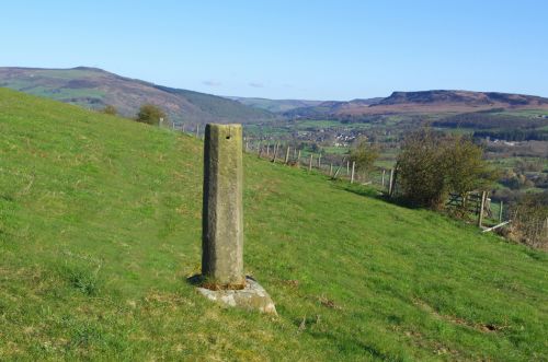
Robin Hood's Stoop / Jim Bell, 16 April 2012.
By Henrik Thiil Nielsen, 2016-09-14. Revised by Henrik Thiil Nielsen, 2017-12-31.
Robin Hood's Stoop on Offerton Moor is an old boundary stone which was perhaps originally part of a medieval wayside cross. According to later tradition Robin Hood shot an arrow from the Stoop all the way to Hathersage churchyard, about 2 km to the NE.[1] Similar traditions relate to Whitby Abbey (North Riding of Yorkshire) and Limlow Hill (Cambridgeshire. The earliest source for this place-name I know of so far is the 6" O.S. map of the area published in 1883, but it seems likely it was included on earlier maps.
Gazetteers
- Dobson, R. B., ed.; Taylor, J., ed. Rymes of Robyn Hood: an Introduction to the English Outlaw (London, 1976), p. 297, s.n. 'Robin Hood's Stoop'.
Sources
- Cameron, Kenneth. The Place-Names of Derbyshire (English Place-Name Society, vols. XXVII-XXIX) (Cambridge, 1959), pt. I, p. 156; and see pt. I, p. lvii.
Maps
- 6" O.S. map Derbyshire X.SE (1883, surveyed 1879-80)
- 1" O.S. map Sheet 99 (Hills) (1896)
- 1" O.S. map Sheet 99 (Outline) (1896)
- 6" O.S. map Derbyshire X.SE (1899, surveyed 1896-97)
- 6" O.S. map Derbyshire X.SE (1923, surveyed 1919)

