
Robin Hood's Cave (Walesby): Difference between revisions
mNo edit summary |
m (Text replacement - "No Copy in NLS" to "No copy in NLS") |
||
| (14 intermediate revisions by the same user not shown) | |||
| Line 1: | Line 1: | ||
__NOTOC__{{ | __NOTOC__{{PlaceNamesItemTop|Lat=53.229970|Lon=-1.004901|AdministrativeDivision=Nottinghamshire|Vicinity=E bank of River Maun, c. 550 m N of Whitewater Lane, Walesby|Type=Natural feature|Interest=Robin Hood name|Status=Extant|Demonym=English|Riding=|GreaterLondon=|Year=1825|Aka=|Century=|Cluster1=Perlethorpe|Cluster2=|Cluster3=|Image=geograph-1261107-by-Tim-Heaton.jpg|Postcards=|ExtraCat1=Places named Robin Hood's Cave|ExtraCat2=|ExtraCat3=|ExtraCat4=|ExtraCat5=|ExtraLink1=Robin Hood's Meadow (Perlethorpe)|ExtraLink2=|ExtraLink3=|ExtraLink4=|ExtraLink5=|ExtraLinkName1=|ExtraLinkName2=|ExtraLinkName3=|ExtraLinkName4=|ExtraLinkName5=|GeopointPrefix=|GeopointSuffix=|StatusSuffix=|DatePrefix=|DateSuffix=}} | ||
{{#display_map:{{#var:Coords}}~{{#replace:{{PAGENAME}}|'|'}}|width=34%}}<div class="pnMapLegend">Robin Hood's Cave, Walesby</div> | {{#display_map:{{#var:Coords}}~{{#replace:{{PAGENAME}}|'|'}}|width=34%|fullscreen=yes}}<div class="pnMapLegend">Robin Hood's Cave, Walesby</div> | ||
[[File:{{#var: | [[File:{{#var:Image}}|thumb|right|500px|Robin Hood's Cave is located opposite the red can / [https://m.geograph.org.uk/photo/1261107 Tim Heaton, 19 Apr. 2009, Creative Commons, via Geograph.]]] | ||
<p id="byline">By Henrik Thiil Nielsen, 2020-10-02. Revised by {{#realname:{{REVISIONUSER}}}}, {{REVISIONYEAR}}-{{REVISIONMONTH}}-{{REVISIONDAY2}}.</p><div class="no-img"> | <p id="byline">By Henrik Thiil Nielsen, 2020-10-02. Revised by {{#realname:{{REVISIONUSER}}}}, {{REVISIONYEAR}}-{{REVISIONMONTH}}-{{REVISIONDAY2}}.</p><div class="no-img"> | ||
Robin Hood's Cave on the east bank of Whitewater – the local name for River Maun – is located about half a kilometre north of Whitewater Lane. The name 'Robin Hood's Cave' is first recorded in an early O.S. map | Robin Hood's Cave on the east bank of Whitewater – the local name for River Maun – is located about half a kilometre north of Whitewater Lane. The name 'Robin Hood's Cave' is first recorded in an early O.S. map published in 1825.<ref>{{:Gover, John Eric Bruce 1940a}}, p. 64.</ref> | ||
Visitors describe it as 'not more than a hollow in the Sherwood Sandstone', which is 'approached by a precarious walk along the base of the cliff'<ref>[https://m.geograph.org.uk/photo/1261107 Geograph: SK6670: Almost Robin Hood's Cave.]</ref> or note that '[i]n reality, there is no cave – just a slight overhang of red sandstone'.<ref>[https://m.geograph.org.uk/photo/5975385 Geogreph: SK6670: At Robin Hood's Cave by The River Maun.]</ref> According to one, '[t]he feet of countless visitors have worn away the topsoil' near the outcrop.<ref>[https://m.geograph.org.uk/photo/5926186 Geograph: SK6670: Sandstone outcrop by the River Maun.]</ref> If the locality attracts many sightseers this is no doubt due to several circumstances. There is of course the alleged Robin Hood-connection, and the rock, a lovely reddish cream, sits by the river in a wooded area, with | Visitors to the cave describe it as 'not more than a hollow in the Sherwood Sandstone', which is 'approached by a precarious walk along the base of the cliff'<ref>[https://m.geograph.org.uk/photo/1261107 Geograph: SK6670: Almost Robin Hood's Cave.]</ref> or note that '[i]n reality, there is no cave – just a slight overhang of red sandstone'.<ref>[https://m.geograph.org.uk/photo/5975385 Geogreph: SK6670: At Robin Hood's Cave by The River Maun.]</ref> According to one, '[t]he feet of countless visitors have worn away the topsoil' near the outcrop.<ref>[https://m.geograph.org.uk/photo/5926186 Geograph: SK6670: Sandstone outcrop by the River Maun.]</ref> If the locality attracts many sightseers this is no doubt due to several circumstances. There is of course the alleged Robin Hood-connection and the proximity to remnants of Sherwood Forest, and the rock, a remarkable and lovely reddish cream, sits by the river in a wooded area, with the [[Robin Hood Way (Nottinghamshire)|Robin Hood Way]] running past it on the east side. | ||
{{ | {{PlaceNamesItemAllusionsAndRecords}} | ||
== Gazetteers == | == Gazetteers == | ||
* {{:Dobson, Richard Barrie 1976a}}, p. 302, ''s.n.'' Robin Hood's Cave [2]. | * {{:Dobson, Richard Barrie 1976a}}, p. 302, ''s.n.'' Robin Hood's Cave [2]. | ||
| Line 15: | Line 15: | ||
== Maps == | == Maps == | ||
* [https://maps.nls.uk/view/115390060#zoom=4&lat=4001&lon=5475&layers=BT 25" O.S. map ''Nottinghamshire'' XIX.6 (1885; surveyed 1884)] | * [https://maps.nls.uk/view/115390060#zoom=4&lat=4001&lon=5475&layers=BT 25" O.S. map ''Nottinghamshire'' XIX.6 (1885; surveyed 1884)] | ||
* 25" O.s. map ''Nottinghamshire'' XIX.6 (''c.'' 1899; rev. ''c.'' 1897-98). No | * 25" O.s. map ''Nottinghamshire'' XIX.6 (''c.'' 1899; rev. ''c.'' 1897-98). No copy in NLS | ||
* [https://maps.nls.uk/geo/explore/#zoom=17&lat=53.23042&lon=-1.00770&layers=168&b=5 25" O.S. map ''Nottinghamshire'' XIX.6 (1920; rev. 1915)] (georeferenced) | * [https://maps.nls.uk/geo/explore/#zoom=17&lat=53.23042&lon=-1.00770&layers=168&b=5 25" O.S. map ''Nottinghamshire'' XIX.6 (1920; rev. 1915)] (georeferenced) | ||
* [https://maps.nls.uk/view/115390063#zoom=5&lat=4111&lon=5617&layers=BT 25" O.S. map ''Nottinghamshire'' XIX.6 (1920; rev. 1915)] | * [https://maps.nls.uk/view/115390063#zoom=5&lat=4111&lon=5617&layers=BT 25" O.S. map ''Nottinghamshire'' XIX.6 (1920; rev. 1915)] | ||
| Line 23: | Line 23: | ||
* [https://maps.nls.uk/view/101602509#zoom=5&lat=2030&lon=5498&layers=BT 6" O.S. map ''Nottinghamshire'' XIX.NW (1921; rev. 1915)] | * [https://maps.nls.uk/view/101602509#zoom=5&lat=2030&lon=5498&layers=BT 6" O.S. map ''Nottinghamshire'' XIX.NW (1921; rev. 1915)] | ||
* [https://maps.nls.uk/geo/explore/#zoom=16&lat=53.22992&lon=-1.00542&layers=6&b=5 6" O.S. map ''Nottinghamshire'' XIX.NW (1900; rev. 1897–98)] (georeferenced).<!-- | * [https://maps.nls.uk/geo/explore/#zoom=16&lat=53.22992&lon=-1.00542&layers=6&b=5 6" O.S. map ''Nottinghamshire'' XIX.NW (1900; rev. 1897–98)] (georeferenced).<!-- | ||
== Discussion == | == Discussion ==--> | ||
== Background == | == Background == | ||
* {{:Nottingham Wayfarers' Rambling Club 1994a}}, pp. 87, 88 (map), 89, 91, 145.<!-- | |||
== Brief mention ==--> | == Brief mention ==--> | ||
{{ | {{PlaceNamesItemAlsoSee}} | ||
== Notes == | == Notes == | ||
<references/> | <references/> | ||
</div> | </div> | ||
{{ | {{ImageGalleryIntroduction}} | ||
<gallery widths="195px"> | <gallery widths="195px"> | ||
geograph-5975385-by-Neil-Theasby.jpg|At Robin Hood's Cave by the River Maun / [https://m.geograph.org.uk/photo/5975385 Neil Theasby, 13 Nov. 2018, Creative Commons, via Geograph.] | geograph-5975385-by-Neil-Theasby.jpg|At Robin Hood's Cave by the River Maun / [https://m.geograph.org.uk/photo/5975385 Neil Theasby, 13 Nov. 2018, Creative Commons, via Geograph.] | ||
| Line 37: | Line 38: | ||
geograph-1261107-by-Tim-Heaton.jpg|Robin Hood's Cave is located opposite the red can / [https://m.geograph.org.uk/photo/1261107 Tim Heaton, 19 Apr. 2009, Creative Commons, via Geograph.] | geograph-1261107-by-Tim-Heaton.jpg|Robin Hood's Cave is located opposite the red can / [https://m.geograph.org.uk/photo/1261107 Tim Heaton, 19 Apr. 2009, Creative Commons, via Geograph.] | ||
geograph-5926186-by-Jonathan-Thacker.jpg|Sandstone outcrop by the River Maun, beneath lies Robin Hood's Cave / [https://m.geograph.org.uk/photo/5926186 Jonathan Thacker, 1 Oct. 2018, Creative Commons, via Geograph.] | geograph-5926186-by-Jonathan-Thacker.jpg|Sandstone outcrop by the River Maun, beneath lies Robin Hood's Cave / [https://m.geograph.org.uk/photo/5926186 Jonathan Thacker, 1 Oct. 2018, Creative Commons, via Geograph.] | ||
geograph-5932283-by-Jonathan-Thacker.jpg|Sandstone outcrop by the River Maun, the colour of the exposed rock is rather startling / [https://m.geograph.org.uk/photo/5932283 Jonathan Thacker, 1 Oct. 2018, Creative Commons, via Geograph.] | |||
</gallery> | </gallery> | ||
{{ | {{PlaceNamesItemNavigation}} | ||
Latest revision as of 01:04, 13 February 2021
| Locality | |
|---|---|
| Coordinate | 53.22997, -1.004901 |
| Adm. div. | Nottinghamshire |
| Vicinity | E bank of River Maun, c. 550 m N of Whitewater Lane, Walesby |
| Type | Natural feature |
| Interest | Robin Hood name |
| Status | Extant |
| First Record | 1825 |

By Henrik Thiil Nielsen, 2020-10-02. Revised by Henrik Thiil Nielsen, 2021-02-13.
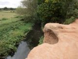
Robin Hood's Cave on the east bank of Whitewater – the local name for River Maun – is located about half a kilometre north of Whitewater Lane. The name 'Robin Hood's Cave' is first recorded in an early O.S. map published in 1825.[1]
Visitors to the cave describe it as 'not more than a hollow in the Sherwood Sandstone', which is 'approached by a precarious walk along the base of the cliff'[2] or note that '[i]n reality, there is no cave – just a slight overhang of red sandstone'.[3] According to one, '[t]he feet of countless visitors have worn away the topsoil' near the outcrop.[4] If the locality attracts many sightseers this is no doubt due to several circumstances. There is of course the alleged Robin Hood-connection and the proximity to remnants of Sherwood Forest, and the rock, a remarkable and lovely reddish cream, sits by the river in a wooded area, with the Robin Hood Way running past it on the east side.
Gazetteers
- Dobson, R. B., ed.; Taylor, J., ed. Rymes of Robyn Hood: an Introduction to the English Outlaw (London, 1976), p. 302, s.n. Robin Hood's Cave [2].
Sources
Maps
- 25" O.S. map Nottinghamshire XIX.6 (1885; surveyed 1884)
- 25" O.s. map Nottinghamshire XIX.6 (c. 1899; rev. c. 1897-98). No copy in NLS
- 25" O.S. map Nottinghamshire XIX.6 (1920; rev. 1915) (georeferenced)
- 25" O.S. map Nottinghamshire XIX.6 (1920; rev. 1915)
- 6" O.S. map Nottinghamshire XIX.NW (1900; rev. 1897–98) (georeferenced)
- 6" O.S. map Nottinghamshire XIX.NW (1884; surveyed 1883–84)
- 6" O.S. map Nottinghamshire XIX.NW (1900; rev. 1897–98)
- 6" O.S. map Nottinghamshire XIX.NW (1921; rev. 1915)
- 6" O.S. map Nottinghamshire XIX.NW (1900; rev. 1897–98) (georeferenced).
Background
Also see
Notes
- ↑ Gover, J.E.B.; Mawer, Allen; Stenton, F.M. The Place-Names of Nottinghamshire (English Place-Name Society, vol. XVII) (Cambridge, 1940), p. 64.
- ↑ Geograph: SK6670: Almost Robin Hood's Cave.
- ↑ Geogreph: SK6670: At Robin Hood's Cave by The River Maun.
- ↑ Geograph: SK6670: Sandstone outcrop by the River Maun.
Image gallery
Click any image to display it in the lightbox, where you can navigate between images by clicking in the right or left side of the current image.
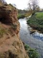
At Robin Hood's Cave by the River Maun / Neil Theasby, 13 Nov. 2018, Creative Commons, via Geograph.
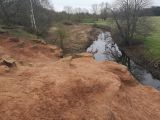
Above Robin Hood's Cave / Stephen Ostler, 25 Jan. 2020, Creative Commons, via Geograph.
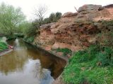
Robin Hood's Cave is located opposite the red can / Tim Heaton, 19 Apr. 2009, Creative Commons, via Geograph.
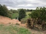
Sandstone outcrop by the River Maun, beneath lies Robin Hood's Cave / Jonathan Thacker, 1 Oct. 2018, Creative Commons, via Geograph.
Sandstone outcrop by the River Maun, the colour of the exposed rock is rather startling / Jonathan Thacker, 1 Oct. 2018, Creative Commons, via Geograph.


