
Robin Hood's Butts (Weaverham) (1): Difference between revisions
m (Text replacement - "{{#var:Coords}}~{{PAGENAME}}" to "{{#var:Coords}}~{{#replace:{{PAGENAME}}|'|'}}") |
mNo edit summary |
||
| (28 intermediate revisions by the same user not shown) | |||
| Line 1: | Line 1: | ||
__NOTOC__{{ | __NOTOC__{{PlaceNamesItemTop|Lat=53.269542|Lon=-2.584250|AdministrativeDivision=Cheshire|Vicinity=''c.'' 250 m S of River Weaver, E of Well Lane; N of Weaverham|Type=Area|Interest=Robin Hood name|Status=Defunct|Demonym=|Riding=|GreaterLondon=|Year=1839|Aka=|Century=|Cluster1=Weaverham|Cluster2=|Cluster3=|Image=Robin-hoods-butts-weaverham-google-earth-street-view-1-1.jpg|Postcards=|ExtraCat1=Places named Robin Hood's Butts|ExtraCat2=|ExtraCat3=|ExtraCat4=|ExtraCat5=|ExtraLink1=|ExtraLink2=|ExtraLink3=|ExtraLink4=|ExtraLink5=|ExtraLinkName1=|ExtraLinkName2=|ExtraLinkName3=|ExtraLinkName4=|ExtraLinkName5=|GeopointPrefix=Near |GeopointSuffix= ?|StatusSuffix=|DatePrefix=|DateSuffix=}} | ||
{{#display_map:{{#var:Coords}}~{{#replace:{{PAGENAME}}|'|'}}|width=34%}}<div class="pnMapLegend"> | {{#display_map:{{#var:Coords}}~{{#replace:{{PAGENAME}}|'|'}}|width=34%|enablefullscreen=yes}}<div class="pnMapLegend">Approximate indication of location of the westernmost of the Robin Hood's Butts.</div> | ||
[[File:{{#var:Image}}|thumb|right|500px|Looking east from Well Lane across the former Robin Hood's Butts / Google Earth Street View.]]<div class="no-img"> | |||
<p id="byline">By Henrik Thiil Nielsen, 2017-01-21. Revised by {{#realname:{{REVISIONUSER}}}}, {{REVISIONYEAR}}-{{REVISIONMONTH}}-{{REVISIONDAY2}}.</p> | <p id="byline">By Henrik Thiil Nielsen, 2017-01-21. Revised by {{#realname:{{REVISIONUSER}}}}, {{REVISIONYEAR}}-{{REVISIONMONTH}}-{{REVISIONDAY2}}.</p> | ||
< | Two irregularly shaped plots of land south of River Weaver and North of Weaverham were known as Robin Hood's Butts in 1839. | ||
< | This entry is concerned with the westernmost of the two butts, which figure in the 1839 tithe award for Weaverham. They had a combined area of 3 acres, 2 roods and 38 perches ({{AcresRoodsPerchesToM2|3|2|38}} m<sup>2</sup>). The landowner is listed as 'Lord Alvanley', i.e. William Arden, 2nd Baron Alvanley (1789–1849); the occupier was a John Cartwright. The tithe award omits the ususally provided information about the state of cultivation of the plot. Between the western and eastern Butt was a plot listed in the tithe award as Rough Hill.<ref>[https://www.thegenealogist.com Tithe award for Weaverham (1839)] (Piece 05, Sub-Piece 416, Image 051, #174 – at The Genealogist) (£); [https://www.thegenealogist.co.uk Tithe map for Weaverham (1831)] (Piece 05, Sub-Piece 416, Sub-Image 001, #174 – at The Genealogist) (£); [https://en.wikipedia.org/wiki/William_Arden,_2nd_Baron_Alvanley Wikipedia: William Arden, 2nd Baron Alvanley.]</ref> Part of the area of the westernmost Robin Hood's Butt is now occupied by the riding school Sandylane Equestrian. | ||
{{ | |||
The name 'Robin Hood's Butts' is often applied to pairs of mounds or hillocks (see [[Places named Robin Hood's Butts]]), but the term 'butt' can also refer to | |||
a 'raised strip of cultivated land between two furrows, a ridge' or a 'small piece of land, esp. of an irregular shape; a paddock'.<ref>[https://www.oed.com/view/Entry/25366 ''OED''], butt, ''n.<sup>2</sup>'', 1. a. and 2. (£)</ref> | |||
It is not clear if the name was applied to mounds or hillocks within these plots or if it referred to the irregular shapes of the plots. One of the English Place-Name Society's volumes on Cheshire notes Robin Hood's Butts in Cuddington,<ref>{{:Dodgson, John McNeal 1970a}}, vol. III, p.200.</ref> a village situated about 2 km SSW of Weaverham. In fact [[Robin Hood's Butts (Weaverham) (3)|these are also located in Weaverham]], not quite 2 km south of the present butt. The latter and its 'partner' can be seen in the detail of the tithe map included in the image gallery below. As the map is not entirely reliable and the layout of the fields in this vicinity has changed considerably since it was drawn, the coordinates we provide for the two fields are approximate.{{PlaceNamesItemAllusionsAndRecords}} | |||
== Gazetteers == | |||
* Not included in {{:Dobson, Richard Barrie 1976a}}, pp. 293-311. | * Not included in {{:Dobson, Richard Barrie 1976a}}, pp. 293-311. | ||
* | == MS sources == | ||
* [https://www.thegenealogist.com Tithe award for Weaverham (1839)] (Piece 05, Sub-Piece 416, Image 051, #174 – at The Genealogist) (£) | |||
* [https://www.thegenealogist.co.uk Tithe map for Weaverham (1831)] (Piece 05, Sub-Piece 416, Sub-Image 001, #174 – at The Genealogist) (£). | |||
== Printed sources == | |||
* {{:Dodgson, John McNeal 1970a}}, vol. III, p.200. | * {{:Dodgson, John McNeal 1970a}}, vol. III, p.200. | ||
{{ | == Maps == | ||
* [https://maps.nls.uk/view/114583159#zoom=4&lat=6420&lon=14976&layers=BT 25" O.S. map ''Cheshire'' XXXIII.7 (1877; surveyed 1872)] | |||
* [https://maps.nls.uk/geo/explore/#zoom=16&lat=53.27167&lon=-2.58035&layers=168&b=5 25" O.S. map ''Cheshire'' XXXIII.8 (1898; rev. 1892)] (georeferenced) | |||
* [https://maps.nls.uk/view/114583162#zoom=4&lat=6528&lon=15411&layers=BT 25" O.S. map ''Cheshire'' XXXIII.7 (1898; rev. 1897)] | |||
* [https://maps.nls.uk/view/114583165#zoom=4&lat=6752&lon=14878&layers=BT 25" O.S. map ''Cheshire'' XXXIII.7 (1910; rev. 1908)] | |||
* [https://maps.nls.uk/view/102341053#zoom=6&lat=7119&lon=10835&layers=BT 6" O.S. map ''Cheshire'' XXXIII (1882; surveyed 1873–77)] | |||
* [https://maps.nls.uk/geo/explore/#zoom=16&lat=53.27030&lon=-2.58524&layers=6&b=5 6" O.S. map ''Cheshire'' XXXIII.NE (1899; rev. 1897)] (georeferenced) | |||
* [https://maps.nls.uk/view/101598766#zoom=4&lat=2405&lon=3952&layers=BT 6" O.S. map ''Cheshire'' XXXIII.NE (1899; rev. 1897)] | |||
* [https://maps.nls.uk/view/101598763#zoom=5&lat=2685&lon=3882&layers=BT 6" O.S. map ''Cheshire'' XXXIII.NE (1911; rev. 1908)] | |||
* [https://maps.nls.uk/view/101598760#zoom=4&lat=2523&lon=3720&layers=BT 6" O.S. map ''Cheshire'' XXXIII.NE (''c.'' 1945; rev. 1938).] | |||
== Background == | |||
* [https://www.oed.com/view/Entry/25366 ''OED''], butt, ''n.<sup>2</sup>'', 1. a. and 2 (£). | |||
* [https://en.wikipedia.org/wiki/Cuddington,_Eddisbury Wikipedia: Cuddington, Eddisbury] | |||
* [https://en.wikipedia.org/wiki/Weaverham Wikipedia: Weaverham] | |||
* [https://en.wikipedia.org/wiki/William_Arden,_2nd_Baron_Alvanley Wikipedia: William Arden, 2nd Baron Alvanley.] | |||
{{PlaceNamesItemAlsoSee}} | |||
== Notes == | |||
<references/> | <references/> | ||
</div> | </div> | ||
{{ImageGalleryIntroduction}} | |||
<gallery widths="195px"> | |||
Robin-hoods-butts-weaverham-google-earth-street-view-1-1.jpg|Looking east from Well Lane across the former Robin Hood's Butts / Google Earth Street View. | |||
Robin-hoods-butts-weaverham-the-genealogist-1.jpg|The two plots numbered 174, near the centre, were known as Robin Hood's Butts. Detail of MS tithe map / © Crown Copyright Images reproduced by courtesy of [https://www.nationalarchives.gov.uk The National Archives, London, England. www.NationalArchives.gov.uk] & [https://www.thegenealogist.co.uk/ www.TheGenealogist.co.uk.] | |||
</gallery> | |||
{{ | {{PlaceNamesItemNavigation}} | ||
Latest revision as of 16:14, 5 May 2022
| Locality | |
|---|---|
| Coordinate | Near 53.269542, -2.58425 ? |
| Adm. div. | Cheshire |
| Vicinity | c. 250 m S of River Weaver, E of Well Lane; N of Weaverham |
| Type | Area |
| Interest | Robin Hood name |
| Status | Defunct |
| First Record | 1839 |

By Henrik Thiil Nielsen, 2017-01-21. Revised by Henrik Thiil Nielsen, 2022-05-05.
Two irregularly shaped plots of land south of River Weaver and North of Weaverham were known as Robin Hood's Butts in 1839.
This entry is concerned with the westernmost of the two butts, which figure in the 1839 tithe award for Weaverham. They had a combined area of 3 acres, 2 roods and 38 perches (15125.13 m2). The landowner is listed as 'Lord Alvanley', i.e. William Arden, 2nd Baron Alvanley (1789–1849); the occupier was a John Cartwright. The tithe award omits the ususally provided information about the state of cultivation of the plot. Between the western and eastern Butt was a plot listed in the tithe award as Rough Hill.[1] Part of the area of the westernmost Robin Hood's Butt is now occupied by the riding school Sandylane Equestrian.
The name 'Robin Hood's Butts' is often applied to pairs of mounds or hillocks (see Places named Robin Hood's Butts), but the term 'butt' can also refer to a 'raised strip of cultivated land between two furrows, a ridge' or a 'small piece of land, esp. of an irregular shape; a paddock'.[2] It is not clear if the name was applied to mounds or hillocks within these plots or if it referred to the irregular shapes of the plots. One of the English Place-Name Society's volumes on Cheshire notes Robin Hood's Butts in Cuddington,[3] a village situated about 2 km SSW of Weaverham. In fact these are also located in Weaverham, not quite 2 km south of the present butt. The latter and its 'partner' can be seen in the detail of the tithe map included in the image gallery below. As the map is not entirely reliable and the layout of the fields in this vicinity has changed considerably since it was drawn, the coordinates we provide for the two fields are approximate.
Gazetteers
- Not included in Dobson, R. B., ed.; Taylor, J., ed. Rymes of Robyn Hood: an Introduction to the English Outlaw (London, 1976), pp. 293-311.
MS sources
- Tithe award for Weaverham (1839) (Piece 05, Sub-Piece 416, Image 051, #174 – at The Genealogist) (£)
- Tithe map for Weaverham (1831) (Piece 05, Sub-Piece 416, Sub-Image 001, #174 – at The Genealogist) (£).
Printed sources
Maps
- 25" O.S. map Cheshire XXXIII.7 (1877; surveyed 1872)
- 25" O.S. map Cheshire XXXIII.8 (1898; rev. 1892) (georeferenced)
- 25" O.S. map Cheshire XXXIII.7 (1898; rev. 1897)
- 25" O.S. map Cheshire XXXIII.7 (1910; rev. 1908)
- 6" O.S. map Cheshire XXXIII (1882; surveyed 1873–77)
- 6" O.S. map Cheshire XXXIII.NE (1899; rev. 1897) (georeferenced)
- 6" O.S. map Cheshire XXXIII.NE (1899; rev. 1897)
- 6" O.S. map Cheshire XXXIII.NE (1911; rev. 1908)
- 6" O.S. map Cheshire XXXIII.NE (c. 1945; rev. 1938).
Background
- OED, butt, n.2, 1. a. and 2 (£).
- Wikipedia: Cuddington, Eddisbury
- Wikipedia: Weaverham
- Wikipedia: William Arden, 2nd Baron Alvanley.
Also see
Notes
- ↑ Tithe award for Weaverham (1839) (Piece 05, Sub-Piece 416, Image 051, #174 – at The Genealogist) (£); Tithe map for Weaverham (1831) (Piece 05, Sub-Piece 416, Sub-Image 001, #174 – at The Genealogist) (£); Wikipedia: William Arden, 2nd Baron Alvanley.
- ↑ OED, butt, n.2, 1. a. and 2. (£)
- ↑ Dodgson, John McN.; Rumble, Alexander R. The Place-Names of Cheshire, pts. I-V (English Place-Name Society, vols. XLIV-XLVIII, LIV, LXXIV) (Cambridge, 1970-72; [s.l.], 1981; Nottingham, 1997), vol. III, p.200.
Image gallery
Click any image to display it in the lightbox, where you can navigate between images by clicking in the right or left side of the current image.
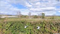
Looking east from Well Lane across the former Robin Hood's Butts / Google Earth Street View.
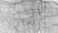
The two plots numbered 174, near the centre, were known as Robin Hood's Butts. Detail of MS tithe map / © Crown Copyright Images reproduced by courtesy of The National Archives, London, England. www.NationalArchives.gov.uk & www.TheGenealogist.co.uk.
