Robin Hood's Butts (Danby Low Moor): Difference between revisions
m (Text replacement - "|service=leaflet}}" to "|service=leaflet|enablefullscreen=yes}}") |
m (Text replacement - "PlaceNamesItemQuery" to "PlaceNamesItemAllusionsAndRecords") |
||
| (11 intermediate revisions by the same user not shown) | |||
| Line 1: | Line 1: | ||
__NOTOC__{{ | __NOTOC__{{PlaceNamesItemTop|Lat=54.492918|Lon=-0.899206|AdministrativeDivision=Yorkshire|Vicinity=Gerrick Moor, c. 1.8 km W of Ravenscar|Type=Prehistoric site|Interest=Robin Hood name|Status=Extant|Demonym=|Riding=North|GreaterLondon=|Year=1856|Aka=|Century=|Cluster1=Gerrick Moor|Cluster2=|Cluster3=|Image=doc-brown-danby-low-moor.jpg|Postcards=|ExtraCat1=Places named Robin Hood's Butts|ExtraCat2=|ExtraCat3=|ExtraCat4=|ExtraCat5=|ExtraLink1=|ExtraLink2=|ExtraLink3=|ExtraLink4=|ExtraLink5=|ExtraLinkName1=|ExtraLinkName2=|ExtraLinkName3=|ExtraLinkName4=|ExtraLinkName5=|GeopointPrefix=|GeopointSuffix=|StatusSuffix=|DatePrefix=|DateSuffix=}} | ||
{{#display_map:54.4944700164169,-0.911824440566522~Robin Hood's Butts;54.4932420211792,-0.905218208614164~Robin Hood's Butts;54.4929444751541,-0.9021383451304~Robin Hood's Butts;54.4929178136085,-0.89920563805206~Robin Hood's Butts|width=34% | {{#display_map:54.4944700164169,-0.911824440566522~Robin Hood's Butts;54.4932420211792,-0.905218208614164~Robin Hood's Butts;54.4929444751541,-0.9021383451304~Robin Hood's Butts;54.4929178136085,-0.89920563805206~Robin Hood's Butts|width=34%|enablefullscreen=yes}}<div class="pnMapLegend">Robin Hood's Butts. The topic of the present page is <br/>the third from the left (west).</div> | ||
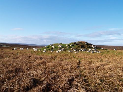
[[File:doc-brown-danby-low-moor.jpg|thumb|right|500px|Robin Hood's Butt is a favourite with the sheep / [http://www.docbrown.info/docspics/idig/idigpage04.htm Doc Brown.]]] | [[File:doc-brown-danby-low-moor.jpg|thumb|right|500px|Robin Hood's Butt is a favourite with the sheep / [http://www.docbrown.info/docspics/idig/idigpage04.htm Doc Brown.]]] | ||
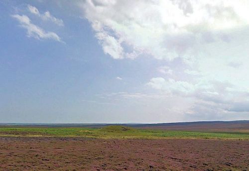
[[File:Robin_Hood's_Butts_(Danby_Low_Moor)_Google_Maps.jpg|500px|thumb||Robin Hood's Butt viewed from the road to Danby / Google Earth.]] | [[File:Robin_Hood's_Butts_(Danby_Low_Moor)_Google_Maps.jpg|500px|thumb||Robin Hood's Butt viewed from the road to Danby / Google Earth.]]<div class="no-img"> | ||
<p id="byline">By Henrik Thiil Nielsen, 2014-07-17. Revised by {{#realname:{{REVISIONUSER}}}}, {{REVISIONYEAR}}-{{REVISIONMONTH}}-{{REVISIONDAY2}}.</p> | <p id="byline">By Henrik Thiil Nielsen, 2014-07-17. Revised by {{#realname:{{REVISIONUSER}}}}, {{REVISIONYEAR}}-{{REVISIONMONTH}}-{{REVISIONDAY2}}.</p> | ||
Three or four ancient barrows on Gerrick Moor and Danby Low Moor on the North Yorkshire Moors area are (or were) known collectively as Robin Hood's Butts. That furthest to the east, as indicated on the Google map, is a large tumulus, about 3.5 m high and c. 30 m in diameter. Canon Atkinson excavated it in 1864, but the primary burial had then already been removed. He found a substantial number of flints, worked and unworked, as well as a secondary burial, an urn, c. 5.5 m from the centre of the mound.<ref>Cf. English Heritage's [http://www.pastscape.org.uk/hob.aspx?hob_id=29138 Pastscape site: Robin Hood's Butts.]</ref> | Three or four ancient barrows on Gerrick Moor and Danby Low Moor on the North Yorkshire Moors area are (or were) known collectively as Robin Hood's Butts. That furthest to the east, as indicated on the Google map, is a large tumulus, about 3.5 m high and c. 30 m in diameter. Canon Atkinson excavated it in 1864, but the primary burial had then already been removed. He found a substantial number of flints, worked and unworked, as well as a secondary burial, an urn, c. 5.5 m from the centre of the mound.<ref>Cf. English Heritage's [http://www.pastscape.org.uk/hob.aspx?hob_id=29138 Pastscape site: Robin Hood's Butts.]</ref> | ||
| Line 11: | Line 10: | ||
The number of mounds included under the name "Robin Hood's Butts" in this vicinity may have decreased over time as mounds that were once clearly visible, perhaps even prominent, landscape features were razed to the ground by so-called antiquarians digging for "curious" artifacts or remains or by people in search of stones and gravel for use as building materials or in road construction. Canon Atkinson, an amateur archaeologist who discussed these mounds in two magazine articles (see section "Background" below), was a noted spoiler of ancient burial mounds.<ref>See {{:Pease, Alfred Edward 1928a}}, p. 63, ''s.n.'' HOUE (quoted on the page on [[Places named Robin Hood's Butts|places named Robin Hood's Butts]]).</ref> So far I have found no earlier source for this place-name than the 6" O.S. map of the area published in 1856 (see Maps section below). | The number of mounds included under the name "Robin Hood's Butts" in this vicinity may have decreased over time as mounds that were once clearly visible, perhaps even prominent, landscape features were razed to the ground by so-called antiquarians digging for "curious" artifacts or remains or by people in search of stones and gravel for use as building materials or in road construction. Canon Atkinson, an amateur archaeologist who discussed these mounds in two magazine articles (see section "Background" below), was a noted spoiler of ancient burial mounds.<ref>See {{:Pease, Alfred Edward 1928a}}, p. 63, ''s.n.'' HOUE (quoted on the page on [[Places named Robin Hood's Butts|places named Robin Hood's Butts]]).</ref> So far I have found no earlier source for this place-name than the 6" O.S. map of the area published in 1856 (see Maps section below). | ||
See the page on [[Places named Robin Hood's Butts|places named Robin Hood's Butts]] for a general discussion and list of such names.{{ | See the page on [[Places named Robin Hood's Butts|places named Robin Hood's Butts]] for a general discussion and list of such names.{{PlaceNamesItemAllusionsAndRecords}} | ||
== Gazetteers == | == Gazetteers == | ||
* [http://britannia.com/tours/rhood/lesseryorks.html Britannia.com – Touring Online: Lesser Robin Hood Sites.] | * [http://britannia.com/tours/rhood/lesseryorks.html Britannia.com – Touring Online: Lesser Robin Hood Sites.] | ||
| Line 29: | Line 28: | ||
* [http://maps.nls.uk/view/100942025#zoom=5&lat=3644&lon=3341&layers=BT O.S. 6" Map Yorkshire Sheet XXX.NE (1953)] (three Robin Hood's Butts indicated). | * [http://maps.nls.uk/view/100942025#zoom=5&lat=3644&lon=3341&layers=BT O.S. 6" Map Yorkshire Sheet XXX.NE (1953)] (three Robin Hood's Butts indicated). | ||
{{ | {{PlaceNamesItemAlsoSee}} | ||
== Notes == | == Notes == | ||
<references/> | <references/> | ||
| Line 36: | Line 35: | ||
</div> | </div> | ||
{{ | {{PlaceNamesItemNavigation}} | ||
Latest revision as of 00:51, 6 January 2021
| Locality | |
|---|---|
| Coordinate | 54.492918, -0.899206 |
| Adm. div. | North Riding of Yorkshire |
| Vicinity | Gerrick Moor, c. 1.8 km W of Ravenscar |
| Type | Prehistoric site |
| Interest | Robin Hood name |
| Status | Extant |
| First Record | 1856 |
the third from the left (west).

By Henrik Thiil Nielsen, 2014-07-17. Revised by Henrik Thiil Nielsen, 2021-01-06.
Three or four ancient barrows on Gerrick Moor and Danby Low Moor on the North Yorkshire Moors area are (or were) known collectively as Robin Hood's Butts. That furthest to the east, as indicated on the Google map, is a large tumulus, about 3.5 m high and c. 30 m in diameter. Canon Atkinson excavated it in 1864, but the primary burial had then already been removed. He found a substantial number of flints, worked and unworked, as well as a secondary burial, an urn, c. 5.5 m from the centre of the mound.[1]
Dobson & Taylor, following previous writers, refer to this and the other Robin Hood's Butts as "[t]hree tumuli on Danby Low Moor and others further north on Gerrick Moor towards Skelton".[2] English Heritage lists the easternmost tumulus, which we are here discussing, as situated in Danby, and this may well be correct, but the tumulus is located at most a couple of hundred meters east of the (other) Butts on Gerrick Moor, not south towards Danby.[3] I have not come across any concrete and specific reference to other Robin Hood's Butts in the area near Danby than those on, or in the immediate vicinity of, Gerrick Moor. Probably these same butts have been variously referred to as being on Gerrick Moor or neighbouring Danby Low Moor. The remains of a Neolithic and a Bronze Age barrow are in fact to be found on Elm Ledge, just north of the village of Danby,[4], but I have found no indication they were ever known as Robin Hood's Butts.
The number of mounds included under the name "Robin Hood's Butts" in this vicinity may have decreased over time as mounds that were once clearly visible, perhaps even prominent, landscape features were razed to the ground by so-called antiquarians digging for "curious" artifacts or remains or by people in search of stones and gravel for use as building materials or in road construction. Canon Atkinson, an amateur archaeologist who discussed these mounds in two magazine articles (see section "Background" below), was a noted spoiler of ancient burial mounds.[5] So far I have found no earlier source for this place-name than the 6" O.S. map of the area published in 1856 (see Maps section below).
See the page on places named Robin Hood's Butts for a general discussion and list of such names.
Gazetteers
- Britannia.com – Touring Online: Lesser Robin Hood Sites.
- Dobson, R. B., ed.; Taylor, J., ed. Rymes of Robyn Hood: an Introduction to the English Outlaw (London, 1976), p. 306, s. n. 'Robin Hood's Butts' [1].
- The Megalithic Portal: Robin Hood's Butts.
- Midgley – A Yorkshire One-Name Study: Places which carry the name Robin Hood.
- Robin Hood: the Facts and the Fiction – Robin Hood Place Names.
Sources
Maps
- O.S. 6" Map Yorkshire Sheet 30 (1856, surveyed 1853) (three Robin Hood's Butts indicated)
- O.S. 6" Map Yorkshire Sheet XXX.NE (1895, surveyed 1892-93) (three Robin Hood's Butts indicated)
- O.S. 6" Map Yorkshire Sheet XXX.NE (1919, surveyed 1911) (three Robin Hood's Butts indicated)
- O.S. 6" Map Yorkshire Sheet XXX.NE (1930, surveyed 1927) (three Robin Hood's Butts indicated)
- O.S. 6" Map Yorkshire Sheet XXX.NE (1953) (three Robin Hood's Butts indicated).
Also see
Notes
- ↑ Cf. English Heritage's Pastscape site: Robin Hood's Butts.
- ↑ Dobson, R. B., ed.; Taylor, J., ed. Rymes of Robyn Hood: an Introduction to the English Outlaw (London, 1976), p. 306, s. n. 'Robin Hood's Butts' [1].
- ↑ See Pastscape site as cited above.
- ↑ Pastscape: Monuments Nos. 29165 and 29168.
- ↑ See Pease, Alfred Edward, compil.; Fairfax-Blakeborough, John, annot. A Dictionary of the Dialect of the North Riding of Yorkshire (Whitby: Horne & Son, 1928), p. 63, s.n. HOUE (quoted on the page on places named Robin Hood's Butts).

