
Robin Hood's Butts (Brow Moor)
| Locality | |
|---|---|
| Coordinate | 54.40374, -0.518758 |
| Adm. div. | North Riding of Yorkshire |
| Vicinity | Brow Moor, 1.8 km W of Ravenscar |
| Type | Prehistoric site |
| Interest | Robin Hood name |
| Status | Extant |
| First Record | 1828 |


By Henrik Thiil Nielsen, 2013-08-06. Revised by Henrik Thiil Nielsen, 2021-01-06.
Robin Hood's Butts are three round barrows on the crest of Stoupe Brow, Brow Moor, 225 m above sea level, not quite 2 km from Ravenscar. They lie about 1 km inland from the south end of Robin Hood's Bay and c. 3.5 km SSW of Robin Hood's Bay town. These mounds seem to have been called Robin Hood's Butts only since the early 19th century, the earliest evidence so far known being Teesdale's 1828 map.[1] Until then, and from at least as early as 1682, the name was applied to two mounds c. 1.4 km to the SE which are now known as Beacon Howes. Made of earth and stone, the three mounds on Stoupe Brow are all scarred by quarrying for stones (probably during the Bronze Age), 19th century excavations, and the construction of a WWII gun pit. Their approximate diametres are 17, 18 and 21 m. There are traces of an outer ditch and counterscarp bank around each of the two largest mounds.[2]
See the page on places named Robin Hood's Butts for a general discussion and list of such names.Template:PlaceNamesItemQuery
Gazetteers
- Dobson, R. B., ed.; Taylor, J., ed. Rymes of Robyn Hood: an Introduction to the English Outlaw (London, 1976), p. 306, s. n. 'Robin Hood's Butts' [3].
Sources
Maps
- Teesdale, Henry. Map of Yorkshire (London, 1828)
- Yorkshire 6" O.S. map Yorkshire 47 (1853, surveyed 1849)
- Yorkshire 6" O.S. map Yorkshire XLVII.SW (1895, surveyed 1891-92)
- Yorkshire 6" O.S. map Yorkshire XLVII.SW (1914, surveyed 1910)
- Yorkshire 6" O.S. map Yorkshire XLVII.SW (1930, surveyed 1926)
- Yorkshire 6" O.S. map Yorkshire XLVII.SW (1952, surveyed 1950)
- 1:25,000 O.S. map NZ90 & Parts of NZ91 (1954.)
Also see
Notes
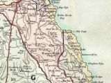
Robin Hood's Butts / Henry Teesdale's Map of Yorkshire (1828).
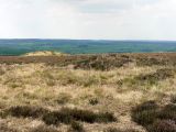
Robin Hood's Butts / Andrew Curtis, May 23, 2010.